Photograph captioned by Fairfax, "Dr Mark Quigley is a lecturer in the department of Geological Sciences at the University of Canterbury. His lecture on the Canterbury earthquake drew such interest that 600 were turned away".

None

These were scattered across the park.

Robbie watches a sand volcano smother his driveway.

Debra points at the beginnings of a sand volcano not long after the big earthquake.

Sand volcanoes put the silt all over the road.

An usual thing to see coming from the ground in Hoon Hay, Christchurch.

The earthquake knocked over the bird bath.
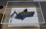
One oblong perspex covered 3-D model of the fault plains associated with the 4 September 2010 Darfield earthquake; top of the model also acts as a map overlay. Geologists continue to study the 4 September 2010 earthquake and consider it is likely to have been a complex event with several faults rupturing simultaneously. This model provides one ...

(I righted the bird bath after the initial earthquake. None of the after-shocks were sufficient to knock it over again.)

Laura, Nicola, and Debra watch a sand volcano build in the Wyn Street gutter.

And, yes, the newspaper always gets through! The Press newspapers were delivered in our area of Hoon Hay in the hours after the earthquake.

One of the many sand volcanos erupting from the ground after the Christchurch earthquake.

Laura and Max return to Christchurch from their holiday in California and inspect the earthquake-caused sand volcano in their front lawn.

Eight white corflute boxes of sediment samples from the borehole drilled adjacent to the Canterbury Museum Rolleston Avenue facade following the 22 February 2011 earthquake. Project number 52160, Bore hole BH02 These sediment samples are from machine drilled borings taken from the land near the Rolleston Avenue facade of Canterbury Museum. The ...

Lots of people were out and about in the streets checking on everyone after the earthquake. When it was clear that everyone was OK, the sand volcanos became the feature of interest.

This has made a huge mess for the residents to clean up. I heard on the news that homes have been damaged by subsidence in areas of earthquake-caused liquefaction like this.

Text at top left reads 'Daft things our forefathers did The cartoon shows several nineteenth century gentlemen observing 'volcanic cones', a 'swamp' and 'faultlines underneath' and deciding to build a city. Context - Specifically the Christchurch earthquakes of 4 September 2010 and 22 February 2011 but generally the way many New Zealand cities are built on or near volcanoes, faultlines and swamps.
Quantity: 1 digital cartoon(s).

It would have been a glorious Spring day in Christchurch had it not been for the magnitude 7.1 earthquake at 4:30 am.
All the water and silt you can see covering the street in this photo erupted from the ground following the earthquake.

Yes, it was a joke. The tours, that is, not the yard filled with earthquake-caused sand volcanos. They were very real. You can see one covering the driveway in this photo.
The signs read as follows.
"Tours run 1/2 hourly.
$5.25 admission.
Eftpos unavailable."
"If you think this is bad... you should see the back!"

Under the caption, young people carrying their baggage flutter into the air, away from Canterbury and toward 'Oz'.
In September GNS Earth Sciences reported that after the earthquakes, the Greendale and associated faults were still moving as they settled into a new configuration. At the same time the young were leaving Canterbury (and New Zealand) for a better future in Australia. The population of New Zealand was moving into a new configuration.
Quantity: 1 digital cartoon(s).
Two huge wrestlers, one representing 'Port Hills fault' and the other 'Greendale fault' struggle together over a broken Christchurch. Another wrestler, representing 'Other faults' appears in the distance yelling 'Is it my turn yet?' Context - Christchurch has now had three major earthquakes and thousands of aftershocks. It now appears likely that the Christchurch quakes resulted from activity on a fault extending directly eastward from the Alpine fault that remained unknown until last year, says Roger Musson, a seismologist at the British Geological Survey in Edinburgh. The new fault first came to light last September (4th) when a stronger but less calamitous quake shook Darfield, 40 kilometres west of Christchurch. Musson says the latest quake (Feb 22, 2011) probably resulted from an eastward continuation of activity on the same fault. "It has probably not moved for tens of thousands of years, so lots of strain built up," says Musson. The third major quake happened on 13th June 2011. (New Scientist - February 22, 2011)
Quantity: 1 digital cartoon(s).