Search
found 302 results
Images for [empty query]; more images...


Paleoseismicity and Rupture Characteristics of the Greendale Fault and For…
Research papers, University of Canterbury Library
The previously unknown Greendale Fault was buried beneath the Canterbury Plains and ruptured in the September 4th 2010 moment magnitude (Mw) 7.1 Darfield Earthquake. The Darfield Earthquake and subsequent Mw 6 or greater events that caused damage to Christchurch highlight the importance of unmapped faults near urban areas. This thesis examines the morphology, age and origin of the Canterbury Plains together with the paleoseismology and surface-rupture displacement distributions of the Greendale Fault. It offers new insights into the surface-rupture characteristics, paleoseismology and recurrence interval of the Greendale Fault and related structures involved in the 2010 Darfield Earthquake. To help constrain the timing of the penultimate event on the Greendale Fault the origin and age of the faulted glacial outwash deposits have been examined using sedimentological analysis of gravels and optically stimulated luminescence (OSL) dating combined with analysis of GPS and LiDAR survey data. OSL ages from this and other studies, and the analysis of surface paleochannel morphology and subsurface gravel deposits indicate distinct episodes of glacial outwash activity across the Canterbury Plains, at ~20 to 24 and ~28 to 33 kyr separated by a hiatus in sedimentation possibly indicating an interstadial period. These data suggest multiple glacial periods between ~18 and 35 kyr which may have occurred throughout the Canterbury region and wider New Zealand. A new model for the Waimakariri Fan is proposed where aggradation is mainly achieved during episodic sheet flooding with the primary river channel location remaining approximately fixed. The timing, recurrence interval and displacements of the penultimate surface-rupturing earthquake on the Greendale Fault have been constrained by trenching the scarp produced in 2010 at two locations. These excavations reveal a doubling of the magnitude of surface displacement at depths of 2-4 m. Aided by OSL ages of sand lenses in the gravel deposits, this factor-of-two increase is interpreted to indicate that in the central section of the Greendale Fault the penultimate surface-rupturing event occurred between ca. 20 and 30 kyr ago. The Greendale Fault remained undetected prior to the Darfield earthquake because the penultimate fault scarp was eroded and buried during Late Pleistocene alluvial activity. The Darfield earthquake rupture terminated against the Hororata Anticline Fault (HAF) in the west and resulted in up to 400 mm of uplift on the Hororata Anticline immediately above the HAF. Folding in 2010 is compared to Quaternary and younger deformation across the anticline recorded by a seismic reflection line, GPS-measured topographic profiles along fluvial surfaces, and river channel sinuosity and morphology. It is concluded that the HAF can rupture during earthquakes dissimilar to the 2010 event that may not be triggered by slip on the Greendale Fault. Like the Greendale Fault geomorphic analyses provide no evidence for rupture of the HAF in the last 18 kyr, with the average recurrence interval for the late Quaternary inferred to be at least ~10 kyr. Surface rupture of the Greendale Fault during the Darfield Earthquake produced one of the most accessible and best documented active fault displacement and geometry datasets in the world. Surface rupture fracture patterns and displacements along the fault were measured with high precision using real time kinematic (RTK) GPS, tape and compass, airborne light detection and ranging (LiDAR), and aerial photos. This allowed for detailed analysis of the cumulative strike-slip displacement across the fault zone, displacement gradient (ground shear strain) and the type of displacement (i.e. faulting or folding). These strain profiles confirm that the rupture zone is generally wide (~30 to ~300 metres) with >50% of displacement (often 70-80%) accommodated by ground flexure rather than discrete fault slip and ground cracking. The greatest fault-zone widths and highest proportions of folding are observed at fault stepovers.
Beyond ductility: parametric testing of a jointed rocking beam-column conn…
Research papers, University of Canterbury Library
Despite their good performance in terms of their design objectives, many modern code-prescriptive buildings built in Christchurch, New Zealand had to be razed after the 2010-2011 Canterbury earthquakes because repairs were deemed too costly due to widespread sacrificial damage. Clearly a more effective design paradigm is needed to create more resilient structures. Rocking, post-tensioned connections with supplemental energy dissipation can contribute to a damage avoidance designs (DAD). However, few have achieved all three key design objectives of damage-resistant rocking, inherent recentering ability, and repeatable, damage-free energy dissipation for all cycles, which together offer a response which is independent of loading history. Results of experimental tests are presented for a near full-scale rocking beam-column sub-assemblage. A matrix of test results is presented for the system under varying levels of posttensioning, with and without supplemental dampers. Importantly, this parametric study delineates each contribution to response. Practical limitations on posttensioning are identified: a minimum to ensure static structural re-centering, and a maximum to ensure deformability without threadbar yielding. Good agreement between a mechanistic model and experimental results over all parameters and inputs indicates the model is robust and accurate for design. The overall results indicate that it is possible to create a DAD connection where the non-linear force-deformation response is loading history independent and repeatable over numerous loading cycles, without damage, creating the opportunity for the design and implementation of highly resilient structures.
After the quakes : Canterbury residents’ perceptions of rebuild contractor…
Research papers, University of Canterbury Library
There has not been substantial research conducted in the area of fraud and natural disasters. Therefore, this study sought to examine the perceptions of Canterbury residents toward the recovery process following the September 2010 and February 2011 earthquakes and whether residents felt as though contractor fraud occurs in Canterbury. A questionnaire was developed to gauge information about Canterbury residents’ self-reports involving the earthquakes, specific contractors involved, parties involved with the recovery process in general, and demographic information. Participants included a total of 213 residents from the Canterbury region who had been involved with contractors and/or insurance companies due to the recovery process. Results indicated that a high percentage of the participants were not satisfied with the recovery process and that almost half of the participants reported feeling scammed by contractors in Canterbury after the 2010 and 2011 earthquakes. Moreover, the results indicate that participants neither agreed with the assessments made about their property losses nor the plans made to recover their properties. In many cases, participants felt pressured and even reluctant to accept these assessments and/or plans. The present study does not seek to explain why contractor fraud exists or what motivates scammers. Conversely, it attempts to demonstrate the perceptions of contractor fraud and satisfaction that have taken place in the aftermath of the Canterbury earthquakes.
The doctrine of frustration, commercial leases and the Canterbury earthqua…
Research papers, University of Canterbury Library
The Canterbury earthquakes in 2010 and 2011 had a significant impact on landlords and tenants of commercial buildings in the city of Christchurch. The devastation wrought on the city was so severe that in an unprecedented response to this disaster a cordon was erected around the central business district for nearly two and half years while demolition, repairs and rebuilding took place. Despite the destruction, not all buildings were damaged. Many could have been occupied and used immediately if they had not been within the cordoned area. Others had only minor damage but repairs to them could not be commenced, let alone completed, owing to restrictions on access caused by the cordon. Tenants were faced with a major problem in that they could not access their buildings and it was likely to be a long time before they would be allowed access again. The other problem was uncertainty about the legal position as neither the standard form leases in use, nor any statute, provided for issues arising from an inaccessible building. The parties were therefore uncertain about their legal rights and obligations in this situation. Landlords and tenants were unsure whether tenants were required to pay rent for a building that could not be accessed or whether they could terminate their leases on the basis that the building was inaccessible. This thesis looks at whether the common law doctrine of frustration could apply to leases in these circumstances, where the lease had made no provision. It analyses the history of the doctrine and how it applies to a lease, the standard form leases in use at the time of the earthquakes and the unexpected and extraordinary nature of the earthquakes. It then reports on the findings of the qualitative empirical research undertaken to look at the experiences of landlords and tenants after the earthquakes. It is argued that the circumstances of landlords and tenants met the test for the doctrine of frustration. Therefore, the doctrine could have applied to leases to enable the parties to terminate them. It concludes with a suggestion for reform in the form of a new Act to govern the special relationship between commercial landlords and tenants, similar to legislation already in place covering other types of relationships like those in residential tenancies and employment. Such legislation could provide dispute resolution services to enable landlords and tenants to have access to justice to determine their legal rights at all times, and in particular, in times of crisis.
Characterizing GeoNet strong motion sites: Site metadata update for the 20…
Research papers, University of Canterbury Library
The 2015 New Zealand strong-motion database provides a wealth of new strong motion data for engineering applications. An important component of this database is the compilation of new site metadata, describing the soil conditions and site response at GeoNet strong motion stations. We have assessed and compiled four key site parameters for the ~460 GeoNet stations that recorded significant historical ground motions. Parameters include: site classification (NZS1170.5), Vs30, fundamental site period (Tsite) and depth to bedrock (Z1.0, i.e. depth to material with Vs > 1000 m/s). In addition, we have assigned a quality estimate (Quality 1 – 3) to these parameters to provide a qualitative estimate of the uncertainty. New highquality Tsite estimates have largely been obtained from newly available HVSR amplification curves and spectral ratios from inversion of regional strong motion data that has been reconciled with available geological information. Good quality Vs30 estimates, typically in urban centres, have also been incorporated following recent studies. Where site-specific measurements of Vs30 are not available, Vs30 is estimated based on surface geology following national Vs30 maps. New Z1.0 values have been provided from 3D subsurface models for Canterbury and Wellington. This database will be used in efforts to guide development and testing of new and existing ground motion prediction models in New Zealand. In particular, it will allow reexamination of the most important site parameters that control and predict site response in a New Zealand setting. Furthermore, it can be used to provide information about suitable rock reference sites for seismological research, and as a guide to site-specific references in the literature. We discuss compilation of the database, preliminary insights so far, and future directions.
Broadband ground motion simulation of the 2010-2011 Canterbury earthquake …
Research papers, University of Canterbury Library
In this paper, we perform hybrid broadband (0-10 Hz) ground motion simulations for the ten most significant events (Mw 4.7-7.1) in the 2010-2011 Canterbury earthquake sequence. Taking advantage of having repeated recordings at same stations, we validate our simulations using both recordings and an empirically-developed ground motion prediction equation (GMPE). The simulation clearly captures the sedimentary basin amplification and the rupture directivity effects. Quantitative comparisons of the simulations with both recordings and the GMPE, as well as analyses of the total residuals (indicating model bias) show that simulations perform better than the empirical GMPE, especially for long period. To scrutinize the ground motion variability, we partitioned the total residuals into different components. The total residual appears to be unbiased, and the use of a 3D velocity structure reduces the long period systematic bias particularly for stations located close to the Banks Peninsula volcanic area.
Earthquakes and the rebuild of Christchurch: how Geography provides the an…
Research papers, University of Canterbury Library
None
The development of parents' capacity to self-regulate while participating …
Research papers, University of Canterbury Library
Previous research has found that the capacity to self-regulate is associated with a number of positive life outcomes and deficits in self-regulation have been linked with poorer life outcomes. Therefore, parent and child self-regulation is an important focus of the Positive Parenting Program for Teenagers (Teen Triple P). The aim of this study was to investigate if Group Teen Triple P was effective in promoting parental self-regulation and adolescent behaviour change in families affected by the earthquakes in Canterbury NZ between 2010 and 2012. METHOD: Five families with teenagers aged 12-16 years were recruited from among families participating in a Group Teen Triple P program specifically implemented by the education authorities for parents self-reporting long-term negative effects of the earthquakes on their family. A single-case multiple-baseline across participants design was used to examine change in target teenager behaviour. Measures of self-regulation skill acquisition were taken using a coding scheme devised for the study from transcripts of three telephone consultations and from three family discussions at pre-intervention, mid-intervention, and post-intervention. Parents and their child also completed questionnaires addressing adolescent functioning, the parent-adolescent relationship and parenting at pre- and post-intervention. RESULTS: The multiple-baseline data showed that parents were successful at changing targeted behaviour for their child. Analysis of the telephone consultations and family discussions showed that parents increased their self-regulation skills over the therapy period and there was positive change in adolescent behavior reported on the Strengths and Difficulties Questionnaire. Additionally, the results suggested that higher rates and levels of self-regulation in the parents were associated with greater improvements in adolescent behaviour. CONCLUSION: This study demonstrated that the Group Teen Triple P -Program was effective in promoting self-regulation in parents and behaviour change in adolescents, specifically in a post-disaster context.
The financial implication of the three design guidelines used during the C…
Research papers, University of Canterbury Library
With the occurrence of natural disasters on the increase, major cities around the world face the potential of complete loss of infrastructure due to design guidelines that do not consider resilience in the design. With the February 22nd, 2011 earthquake in Christchurch, being the largest insured event, lessons learnt from the rebuild will be vital for the preparation of future disasters. Therefore the objective of this research is to understand the financial implications of the changes to the waste water design guidelines used throughout the five year rebuild programme of works. The research includes a study of the SCIRT alliance model selected for the delivery that is flexible enough to handle changes in the design with minimal impact on the direct cost of the rebuild works. The study further includes the analysis and compares the impact of the three different guidelines on maintenance and replacement cost over the waste water pipe asset life. The research concludes that with the varying ground conditions in Christchurch and also the wide variety of materials in use in the waste water network up to the start of the CES, the rebuild was not a ‘one size fits all’ approach.
The Quakebox: A container for post-quake oral history
Research papers, University of Canterbury Library
In this paper Paul Millar outlines the development of the University of Canterbury Quakebox project, a collaborative venture between the UC CEISMIC Canterbury Earthquakes Digital Archive and the New Zealand Institute of Language Brain and Behaviour to preserve people’s earthquake stories for the purposes of research, teaching and commemoration. The project collected over 700 stories on high definition video, and Millar is now looking at using the corpus to underpin a longitudinal study of post-quake experience.
'"Thank goodness for our little radio": Researching post-quake radio audie…
Research papers, University of Canterbury Library
This article discusses the use of radio after major earthquakes in Christchurch, New Zealand, in 2010 and 2011. It draws on archival sources to retrospectively research post-quake audiences in the terms people used during and soon after the earthquakes through personal narratives and Twitter. Retrospective narratives of earthquake experiences affirm the value of radio for communicating the scale of disaster and comforting listeners during dislocation from safe home spaces. In the narratives radio is often compared with television, which signifies electricity supply and associated comfort but also visually confirms the city’s destruction. Twitter provides insights into radio use from within the disaster period, but its more global reach facilitates reflection on online and international radio from outside the disaster-affected area. This research demonstrates the value of archival audience research, and finds that the combination of online radio and Twitter enables a new form of participatory disaster spectatorship from afar.
20160104_1608_7D2-20 Porritt Park (004/366)
Images, eqnz.chch.2010
Porritt Park was, before the earthquakes, the headquarters of hockey in this region. Two astro-turf fields (the main one was other side of the building), and corporate offices etc. The earthquakes buckled all the playing surfaces and damaged the buildings; a couple of smaller ones have been removed. Hockey shifted the other side of the city t...
20160104_1602_7D2-20 Porritt Park
Images, eqnz.chch.2010
Porritt Park was, before the earthquakes, the headquarters of hockey in this region. Two astro-turf fields (the main one was to the left of the building), and corporate offices etc. The earthquakes buckled all the playing surfaces and damaged the buildings; a couple of smaller ones have been removed. Hockey shifted the other side of the cit...
20160415_0029_1D3-24 Red Zone Closures
Images, eqnz.chch.2010
The permanent closure (to motor vehicles) of the Bexley red zone streets has started. This was once the main south-north route just west of the Avon River in the New Brighton area, till an expressway (ring road) was built about 80m to the west (right) about 12-13 years ago. Then it became just another suburban street, but now all the houses ...
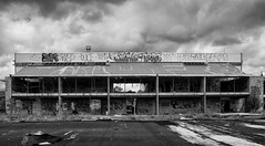
20160307_6607_7D2-110 Interior removal
Images, eqnz.chch.2010
The Forsyth Barr building has stood silent and empty (except the occasional intruder and pigeons) since the February 2011 earthquake. It was sold "as is" and I understand that it is now going to be fitted out as a hotel. This is the building that had severe stairwell damage during the quake necessitating people being lowered via ropes etc on t...
20160415_0039_1D3-40 The Wobbly Jetty - 1 (106/366) [Explored]
Images, eqnz.chch.2010
The South New Brighton jetty was rebuilt a couple of years before the 2010 and 2011 earthquakes wrecked it. Then, it was straight, level and all railings on left side were intact. Was closed to the public for about four years but is open now.
20160307_6619_7D2-125 Covering up
Images, eqnz.chch.2010
One of the most beautiful pieces of wall art (added to the blank walls after buildings were demolished following the earthquakes) in Christchurch, is now being hidden by a new building in front of it. www.flickr.com/photos/johnstewartnz/15499321681/in/...
20160307_0036_EOS M-41 Summit Road closed
Images, eqnz.chch.2010
None
20160415_0044_1D3-38 The Wobbly Jetty - 2
Images, eqnz.chch.2010
The South New Brighton jetty was rebuilt a couple of years before the earthquakes wrecked it. Was closed to the public for about four years but is open now.
20160307_0012_1D3-32 Subway is closed (067/366)
Images, eqnz.chch.2010
The Subway shop in the High Street Mall has not operated since lunch time on the 22nd February 2011 when the most damaging of Christchurch and Canterbury's earthquakes struck. I assume the building is still to be demolished.
20160307_6634_7D2-82 Really Wild!
Images, eqnz.chch.2010
A section of retaining wall that tilted in the Christchurch 2011 earthquake. At the Edmunds Band Rotunda sight. Still not repaired,
20160307_6626_7D2-200 Pigeon City
Images, eqnz.chch.2010
Pigeons sit on the remains of one of the tallest buildings in Christchurch that was 95% demolished two or three years ago. The basement (now filled with water) and the columns remain. Demolished due to damage from the Christchurch 2011 earthquake.
The City is in Rebuild phase (110/366)
Images, eqnz.chch.2010
20160419_7732_7D2-400 The City is in Rebuild phase (110/366) A totally different view to a few years ago. Most of the tall buildings have gone and construction is underway on a lot of new buildings, View from across the Estuary in Redcliffs. A couple of days ago the government agency controlling the post-earthquake work (CERA - Canterbury Ea...
20160703_144759_GT-S7275T-04 New sea wall at Redcliffs (185/366)
Images, eqnz.chch.2010
20160703_144759_GT-S7275T-04 New sea wall at Redcliffs (185/366) I went for a drive in my second car mainly to charge the battery up and forgot to take my camera gear so only had my phone. This is the new rock wall to replace the severely damaged previous one (in the February 2011 earthquake). Work is still underway on the car parking and p...
20160612_8429_1D3-40 Abandoned and maybe forgotten
Images, eqnz.chch.2010
AMI Stadium (Lancaster Park), not used since the February 2011 earthquake. It was used predominantly for rugby and cricket. We are still waiting to see what the outcome is for this stadium. Government want a new one closer to the CBD, so there is talk of this being demolished, while others want it repaired. The concrete pad lower left is ...
20160613_0044_7D2-100 Jetty Closed
Images, eqnz.chch.2010
The South New Brighton jetty has been closed for 3 or 4 years (fenced off) then the fence was removed and it was "open", but nothing has happened to it since the earthquakes, but it is closed again now, although it looks like a home made sign!
20160612_8434_1D3-40 Ticket Sales (164/366)
Images, eqnz.chch.2010
The ticket office at Lancaster Park (AMI Stadium), not used since the February 2011 earthquake. Windows broken and door boarded up. We are still waiting to see what the outcome is for this stadium. Government want a new one closer to the CBD, so there is talk of this being demolished, while others want it repaired.
20161018_9063_7D2-70 Restricted Area (292/366)
Images, eqnz.chch.2010
In the suburban red zone on Avonside Drive.
20161112_9965_7D2-24 Another view of part of the Cultivate Christchurch in…
Images, eqnz.chch.2010
None
20161112_9961_7D2-70 The future face of Christchurch?
Images, eqnz.chch.2010
Cultivate Christchurch is operating this urban farm in the city, about 5-10 minutes walk to Cathedral Square. Many of the buildings in this area were demolished after the earhquakes, and in the background is a new building on Kilmore Street.