Search
found 52 results
Images for landscape; more images...
Topophilia and topophobia in the post-earthquake landscape of Christchurch…
Research papers, Lincoln University
Earthquakes rupture not only the objective realm of the physical landscape, but also the subjective landscape of emotions. Using the concepts of topophilia and topophobia developed by Yi-Fu Tuan as theories of love and fear of place, this paper investigates the impact of Christchurch’s earthquakes of 2010 and 2011 on relationships with the city’s landscape. Published accounts of the earthquakes in newspapers from around New Zealand are examined for evidence of how people responded to the situation, in particular their shifting relationship with familiar landscapes. The reports illustrate how residents and visitors reacted to the actual and perceived changes to their surroundings, grappling with how a familiar place had become alien and often startling. The extreme nature of the event and the death toll of 185 heightened perceptions of the landscape, and even the most taken-for-granted elements of the landscape became amplified in significance. Enhanced understanding of the landscape of emotions is a vital component of wellbeing. Through recognising that the impact of disasters and perceived threats to familiar places has a profound emotional effect, the significance of sense of place to wellbeing can be appreciated.
Laminated Artwork: Trinity
Images, Canterbury Museum
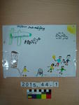
One rectangular A4 landscape multicoloured artwork by Trinity [Jack-Midgley?] for her Uncle, Kyle Jack-Midgley. Drawn for
Stable isotopes as indicators of nitrate attenuation across landscapes
Research papers, Lincoln University
Mitigating the cascade of environmental damage caused by the movement of excess reactive nitrogen (N) from land to sea is currently limited by difficulties in precisely and accurately measuring N fluxes due to variable rates of attenuation (denitrification) during transport. This thesis develops the use of the natural abundance isotopic composition of nitrate (δ15N and δ18O of NO₃-) to integrate the spatialtemporal variability inherent to denitrification, creating an empirical framework for evaluating attenuation during land to water NO₃- transfers. This technique is based on the knowledge that denitrifiers kinetically discriminate against 'heavy' forms of both N and oxygen (O), creating a parallel enrichment in isotopes of both species as the reaction progresses. This discrimination can be quantitatively related to NO₃- attenuation by isotopic enrichment factors (εdenit). However, while these principles are understood, use of NO₃- isotopes to quantify denitrification fluxes in non-marine environments has been limited by, 1) poor understanding of εdenit variability, and, 2) difficulty in distinguishing the extent of mixing of isotopically distinct sources from the imprint of denitrification. Through a combination of critical literature analysis, mathematical modelling, mesocosm to field scale experiments, and empirical studies on two river systems over distance and time, these short comings are parametrised and a template for future NO₃- isotope based attenuation measurements outlined. Published εdenit values (n = 169) are collated in the literature analysis presented in Chapter 2. By evaluating these values in the context of known controllers on the denitrification process, it is found that the magnitude of εdenit, for both δ15N and δ18O, is controlled by, 1) biology, 2) mode of transport through the denitrifying zone (diffusion v. advection), and, 3) nitrification (spatial-temporal distance between nitrification and denitrification). Based on the outcomes of this synthesis, the impact of the three factors identified as controlling εdenit are quantified in the context of freshwater systems by combining simple mathematical modelling and lab incubation studies (comparison of natural variation in biological versus physical expression). Biologically-defined εdenit, measured in sediments collected from four sites along a temperate stream and from three tropical submerged paddy fields, varied from -3‰ to -28‰ depending on the site’s antecedent carbon content. Following diffusive transport to aerobic surface water, εdenit was found to become more homogeneous, but also lower, with the strength of the effect controlled primarily by diffusive distance and the rate of denitrification in the sediments. I conclude that, given the variability in fractionation dynamics at all levels, applying a range of εdenit from -2‰ to -10‰ provides more accurate measurements of attenuation than attempting to establish a site-specific value. Applying this understanding of denitrification's fractionation dynamics, four field studies were conducted to measure denitrification/ NO₃- attenuation across diverse terrestrial → freshwater systems. The development of NO₃- isotopic signatures (i.e., the impact of nitrification, biological N fixation, and ammonia volatilisation on the isotopic 'imprint' of denitrification) were evaluated within two key agricultural regions: New Zealand grazed pastures (Chapter 4) and Philippine lowland submerged rice production (Chapter 5). By measuring the isotopic composition of soil ammonium, NO₃- and volatilised ammonia following the bovine urine deposition, it was determined that the isotopic composition of NO₃ - leached from grazed pastures is defined by the balance between nitrification and denitrification, not ammonia volatilisation. Consequently, NO₃- created within pasture systems was predicted to range from +10‰ (δ15N)and -0.9‰ (δ18O) for non-fertilised fields (N limited) to -3‰ (δ15N) and +2‰ (δ18O) for grazed fertilised fields (N saturated). Denitrification was also the dominant determinant of NO₃- signatures in the Philippine rice paddy. Using a site-specific εdenit for the paddy, N inputs versus attenuation were able to be calculated, revealing that >50% of available N in the top 10 cm of soil was denitrified during land preparation, and >80% of available N by two weeks post-transplanting. Intriguingly, this denitrification was driven by rapid NO₃- production via nitrification of newly mineralised N during land preparation activities. Building on the relevant range of εdenit established in Chapters 2 and 3, as well as the soil-zone confirmation that denitrification was the primary determinant of NO₃- isotopic composition, two long-term longitudinal river studies were conducted to assess attenuation during transport. In Chapter 6, impact and recovery dynamics in an urban stream were assessed over six months along a longitudinal impact gradient using measurements of NO₃- dual isotopes, biological populations, and stream chemistry. Within 10 days of the catastrophic Christchurch earthquake, dissolved oxygen in the lowest reaches was <1 mg l⁻¹, in-stream denitrification accelerated (attenuating 40-80% of sewage N), microbial biofilm communities changed, and several benthic invertebrate taxa disappeared. To test the strength of this method for tackling the diffuse, chronic N loading of streams in agricultural regions, two years of longitudinal measurements of NO₃- isotopes were collected. Attenuation was negatively correlated with NO₃- concentration, and was highly dependent on rainfall: 93% of calculated attenuation (20 kg NO₃--N ha⁻¹ y⁻¹) occurred within 48 h of rainfall. The results of these studies demonstrate the power of intense measurements of NO₃- stable isotope for distinguishing temporal and spatial trends in NO₃ - loss pathways, and potentially allow for improved catchment-scale management of agricultural intensification. Overall this work now provides a more cohesive understanding for expanding the use of NO₃- isotopes measurements to generate accurate understandings of the controls on N losses. This information is becoming increasingly important to predict ecosystem response to future changes, such the increasing agricultural intensity needed to meet global food demand, which is occurring synergistically with unpredictable global climate change.
Sustainability, microclimate and culture in post-earthquake Christchurch
Research papers, Lincoln University
A series of earthquakes has forced Christchurch to re-plan and rebuild. Discussions about rebuilding strategies have emphasized the intention of making it a city for the future, sustainable and vibrant. This paper discusses the relationship between microclimate and urban culture in Christchurch based upon the concept of urban comfort. It explores the relationships between environment, people and culture to help understand the local requirements for urban landscape design. In this paper we claim that cultural requirements also should be taken into account when looking for sustainable strategies. A distinctive feature of this research is its focus on the way people are adapting to both surviving prequake and new post‐quake environments. Preliminary findings from the first year of field work using participant observation and 61 in‐depth interviews with Christchurch residents are presented. The interviews were carried out in a variety of urban settings including: established sites (places sustaining relatively little damage) and emerging sites (those requiring rebuilding) during 2011‐2012. Evidence from the interviews highlight future challenges regarding sustainability and urban comfort issues. Post‐quake Christchurch presents a remarkable opportunity to design an urban landscape which provides environmental, economic, social and cultural sustainability. However, to achieve successful outcomes it is fundamental to respond to the local culture. Field data suggest that the strong connections between urban and rural settings present in local culture, lifestyle and landscape generate a particular aesthetic and recreation preference for urban spaces, which should be considered in the urban landscape design strategies.
Laminated Artwork: Nathan Jack-Midgley
Images, Canterbury Museum
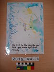
One rectangular A4 landscape artwork by Nathan Jack-Midgley depicting an aeroplane, animals and people at a memorial service for Kyle Brandon Jack-Midgley, June 2013. Drawn for
Nisbet, Alastair, 1958- :'Looks like drought on the landscape!' 9 March 20…
Images, Alexander Turnbull Library
The New Zealand public contemplate a dead drought stricken landscape. As well as lack of water, there is a lack of moderate pay scales for CEOs, satisfaction with EQC, quality TV, generous insurance companies, brilliant Solid Energy management, the integrity of John Banks (and by implication that of other MPs), quality education ministers, worthwhile overseas trips by the Prime Minister, 'clever' NZ First MPs and a boost for the West Coast among others. Considered from a Canterbury perspective, the drought of early 2013 becomes a symbol for many of the recent political and social ailments afflicting the land. Quantity: 1 digital cartoon(s).
Initial demographic and economic changes for Maori in a post-disaster land…
Research papers, Lincoln University
The city of Ōtautahi/Christchurch experienced a series of earthquakes that began on September 4th, 2010. The most damaging event occurred on February 22nd, 2011 but significant earthquakes also occurred on June 13th and December 23rd with aftershocks still occurring well into 2012. The resulting disaster is the second deadliest natural disaster in New Zealand’s history with 185 deaths. During 2011 the Canterbury earthquakes were one of the costliest disasters worldwide with an expected cost of up to $NZ30 billion. Hundreds of commercial buildings and thousands of houses have been destroyed or are to be demolished and extensive repairs are needed for infrastructure to over 100,000 homes. As many as 8,900 people simply abandoned their homes and left the city in the first few months after the February event (Newell, 2012), and as many as 50,000 may leave during 2012. In particular, young whānau and single young women comprised a disproportionate number of these migrants, with evidence of a general movement to the North Island. Te Puni Kōkiri sought a mix of quantitative and qualitative research to examine the social and economic impacts of the Christchurch earthquakes on Māori and their whānau. The result of this work will be a collection of evidence to inform policy to support and assist Māori and their whānau during the recovery/rebuild phases. To that end, this report triangulates available statistical and geographical information with qualitative data gathered over 2010 and 2011 by a series of interviews conducted with Māori who experienced the dramatic events associated with the earthquakes. A Māori research team at Lincoln University was commissioned to undertake the research as they were already engaged in transdisciplinary research (began in the May 2010), that focused on quickly gathering data from a range of Māori who experienced the disaster, including relevant economic, environmental, social and cultural factors in the response and recovery of Māori to these events. Participants for the qualitative research were drawn from Māori whānau who both stayed and left the city. Further data was available from ongoing projects and networks that the Lincoln research team was already involved in, including interviews with Māori first responders and managers operating in the CBD on the day of the February event. Some limited data is also available from younger members of affected whānau. Māori in Ōtautahi/Christchurch City have exhibited their own culturally-attuned collective responses to the disaster. However, it is difficult to ascertain Māori demographic changes due to a lack of robust statistical frameworks but Māori outward migration from the city is estimated to range between 560 and 1,100 people. The mobility displayed by Māori demonstrates an important but unquantified response by whānau to this disaster, with emigration to Australia presenting an attractive option for young Māori, an entrenched phenomenon that correlates to cyclical downturns and the long-term decline of the New Zealand economy. It is estimated that at least 315 Māori have emigrated from the Canterbury region to Australia post-quake, although the disaster itself may be only one of a series of events that has prompted such a decision. Māori children made up more than one in four of the net loss of children aged 6 to 15 years enrolled in schools in Greater Christchurch over the year to June 2011. Research literature identifies depression affecting a small but significant number of children one to two years post-disaster and points to increasing clinical and organisational demands for Māori and other residents of the city. For those residents in the eastern or coastal suburbs – home to many of the city’s Māori population - severe damage to housing, schools, shops, infrastructure, and streets has meant disruption to their lives, children’s schooling, employment, and community functioning. Ongoing abandonment of homes by many has meant a growing sense of unease and loss of security, exacerbated by arson, burglaries, increased drinking, a stalled local and national economy, and general confusion about the city’s future. Māori cultural resilience has enabled a considerable network of people, institutions, and resources being available to Māori , most noticeably through marae and their integral roles of housing, as a coordinating hub, and their arguing for the wider affected communities of Christchurch. Relevant disaster responses need to be discussed within whānau, kōhanga, kura, businesses, communities, and wider neighbourhoods. Comprehensive disaster management plans need to be drafted for all iwi in collaboration with central government, regional, and city or town councils. Overall, Māori are remarkably philosophical about the effects of the disaster, with many proudly relishing their roles in what is clearly a historic event of great significance to the city and country. Most believe that ‘being Māori’ has helped cope with the disaster, although for some this draws on a collective history of poverty and marginalisation, features that contribute to the vulnerability of Māori to such events. While the recovery and rebuild phases offer considerable options for Māori and iwi, with Ngāi Tahu set to play an important stakeholder in infrastructural, residential, and commercial developments, some risk and considerable unknowns are evident. Considerable numbers of Māori may migrate into the Canterbury region for employment in the rebuild, and trades training strategies have already been established. With many iwi now increasingly investing in property, the risks from significant earthquakes are now more transparent, not least to insurers and the reinsurance sector. Iwi authorities need to be appraised of insurance issues and ensure sufficient coverage exists and investments and developments are undertaken with a clear understanding of the risks from natural hazards and exposure to future disasters.
Laminated Artwork: Aaliyah
Images, Canterbury Museum
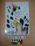
One rectangular A4 landscape artwork by Aaliyah [Jack-Midgley?] depicting a boat on one side and a multi-coloured image on reverse, for her Uncle, Kyle Jack-Midgley. Drawn for
The River Photograph 2013:10:26 (2)
Images, UC QuakeStudies
A photograph of a floating installation on the Avon River. The installation consists of four chairs and a table situated on a grass-covered platform. It was created by students from Lincoln University's School of Landscape Architecture for Canterbury Tales, a carnivalesque procession and the main event of FESTA 2013.
Christchurch: The Transitional City Pt IV, pages 290-291: Victoria Green
Articles, UC QuakeStudies
A PDF copy of pages 290-291 of the book Christchurch: The Transitional City Pt IV. The pages document the transitional project 'Victoria Green'. Photos with permission from Greening the Rubble
The River Photograph 2013:10:27 (2)
Images, UC QuakeStudies
A photograph of a floating installation titled The River on the Avon River. The installation consists of four chairs and a table situated on a grass-covered platform. It was created by students from Lincoln University's School of Landscape Architecturefor Canterbury Tales, a carnivalesque procession and the main event of FESTA 2013.
The River Photograph 2013:10:27 (1)
Images, UC QuakeStudies
A photograph of a floating installation titled The River on the Avon River. The installation consists of four chairs and a table situated on a grass-covered platform. It was created by students from Lincoln University's School of Landscape Architecturefor Canterbury Tales, a carnivalesque procession and the main event of FESTA 2013.
Digital Photograph: London and Oxford Streets
Images, Canterbury Museum
One landscape colour digital photograph taken on 27 May 2013 of London Street in Lyttelton. Taken from Sumner Road looking west across the intersection of London and Oxford Streets. The photograph shows several empty sections and the remaining buildings. The Lyttelton streetscape has changed dramatically from its pre-earthquake appearance and w...
Digital Photograph: Lyttelton Main School
Images, Canterbury Museum
One landscape colour digital photograph taken on 26 May 2013 of Lyttelton Main School. The photograph is taken from St Davids Street looking northwest. One of the broader consequences of the 2010-2011 Canterbury earthquakes has been the Ministry of Education’s Shaping Education – Future Direction Review of Schools in the Greater Christchurch Ar...
Digital Photograph: Elevated view of London Street, Lyttelton
Images, Canterbury Museum
One landscape colour digital photograph taken on 26 May 2013 of London Street, Lyttelton. The photograph was taken from St Davids Street looking west. The roofs of the portable buildings forming the temporary Lyttelton Police station are visible in the foreground. The Lyttelton Port Company offices and Tunnel Portal are prominent in the midgrou...
Digital Photograph: Mitre Hotel
Images, Canterbury Museum
One landscape colour digital photograph taken on 26 May 2013 on the corner of Norwich Quay and Canterbury Street, Lyttelton. The photograph shows the Mitre Hotel surrounded by temporary fencing. Three years after the 2010-2011 earthquakes there are still many uncertainties about which buildings can or will be retained. These buildings, or parts...
Christchurch: The Transitional City Pt IV, pages 292-293: Car Park Frontage
Articles, UC QuakeStudies
A PDF copy of pages 292-293 of the book Christchurch: The Transitional City Pt IV. The pages document the transitional project 'Car Park Frontage'. Photos with permission from Greening the Rubble
The River Photograph 2013:10:27 12:33:43
Images, UC QuakeStudies
A photograph of a floating installation titled The River on the Avon River. The installation consists of dresser, stool and lamp, situated on a grass-covered platform, with net curtains hanging from the frame. It was created by students from Lincoln University's School of Landscape Architecture for Canterbury Tales, a carnivalesque procession and the main event of FESTA 2013.
The River Photograph 2013:10:27 13:01:18
Images, UC QuakeStudies
A photograph of painted bird cut-outs hanging from a tree next to the Avon River on Oxford Terrace, near the Worcester Street bridge. The decorations were part of an installation titled The River, created by students from Lincoln University's School of Landscape Architecture for Canterbury Tales, a carnivalesque procession and the main event of FESTA 2013.
The River Photograph 2013:10:25 17:53:04
Images, UC QuakeStudies
A photograph of painted bird cut-outs hanging from a tree next to the Avon River on Oxford Terrace, near the Worcester Street bridge. The decorations were part of an installation titled The River, created by students from Lincoln University's School of Landscape Architecture for Canterbury Tales, a carnivalesque procession and the main event of FESTA 2013.
The River Photograph 2013:10:25 17:53:32
Images, UC QuakeStudies
A photograph of a floating installation on the Avon River. The installation consists of four chairs and a table situated on a grass-covered platform, with net curtains hanging from the frame. It was created by students from Lincoln University's School of Landscape Architecture for Canterbury Tales, a carnivalesque procession and the main event of FESTA 2013.
The River Photograph 2013:10:25 15:36:30
Images, UC QuakeStudies
A photograph of a floating installation on the Avon River. The installation consists of dresser, stool and lamp, situated on a grass-covered platform, with net curtains hanging from the frame. It was created by students from Lincoln University's School of Landscape Architecture for Canterbury Tales, a carnivalesque procession and the main event of FESTA 2013.
Digital Photograph: Godley Head Lighthouse
Images, Canterbury Museum
One landscape colour digital photograph taken on 26 May 2013 showing the Godley Head Lighthouse and cliffs. Taken from the entrance to Lyttelton Harbour looking north. The Godley Head Lighthouse (K4286) was discontinued on 6 July 2012. Volcanic banding is visible in the face of the cliffs. There were several major rock falls along the coastal ...
Digital Photograph: Earthquake damage to searchlight emplacements, Godley …
Images, Canterbury Museum
One landscape colour digital photograph taken on 26 May 2013 showing the southern cliffs of Godley Head. Taken from the middle of the shipping channel. Some earthquake damage to the cliffs is visible. There were several major rock falls along the coastal cliffs near Christchurch and Lyttelton Harbour. At Godley Head these caused damage to the W...
Digital Photograph: Godley Head
Images, Canterbury Museum
One landscape colour digital photograph taken on 26 May 2013 showing the southern cliffs of Godley Head, taken from the middle of the shipping channel. Some earthquake damage to the cliffs is visible. There were several major rock falls along the coastal cliffs near Christchurch and Lyttelton Harbour. At Godley Head these caused damage to the ...
Digital Photograph: Norwich Quay, Lyttelton.
Images, Canterbury Museum
One landscape colour digital photograph taken on 26 May 2013 on the corner of Norwich Quay and Canterbury Street, Lyttelton. The photograph shows the sites of the Royal Hotel, Shadbolt House, and the Lyttelton Hotel along Norwich Quay. The Wunderbar and the repair and strengthening work underway on the Lyttelton Working Mens Club/The Loons are v...
Digital Photograph: Godley Head, Lyttelton Harbour
Images, Canterbury Museum
One landscape colour digital photograph taken on 26 May 2013 off Godley Head looking north to Boulder Bay and Taylors Mistake. Rock which fell from the cliffs is heaped at the waters edge. Volcanic banding is visible in the face of the cliffs. There were several major rock falls along the coastal cliffs near Christchurch and Lyttelton Harbour....
Digital Photograph: Sumner Head
Images, Canterbury Museum
One landscape colour digital photograph taken on 26 May 2013 off Godley Head looking north towards Sumner Head. There were several major rock falls along the coastal cliffs near Christchurch and Lyttelton Harbour. In and around the suburb of Sumner some of these falls necessitated the abandonment of houses in areas where cliffs had given way or...
COCA Window Projects
Other, National Library of New Zealand
An intermittent collaboration between the Centre of Contemporary Art and a series of local artists looking to present new work which explores the realities of the post-earthquake cultural landscape in Christchurch. The artworks by Ed Lust, Sam Eng, and Robyn Wester each utilise the empty window space of the window and carport of the damaged COCA building which is awaiting repair.
The River Photograph 2013:10:27 (3)
Images, UC QuakeStudies
A photograph of a floating installation on the Avon River. The installation consists of two armchairs, a table and a floor lamp situated on a grass-covered platform, with net curtains hanging from the frame. It was created by students from Lincoln University's School of Landscape Architecture for Canterbury Tales, a carnivalesque procession and the main event of FESTA 2013.
- 1
- »