
Search
found 116 results
Images for landscape; more images...

Land Information to re-survey Canterbury's landscape
Audio, Radio New Zealand
In Canterbury, work has started on re-surveying the region's landscape, following the 7.1-magnitude earthquake in September.
Streetscape: dialogues of street + house
Research papers, Lincoln University
An often overlooked aspect of urban housing development is the composition of the space between buildings; the streetscape. The pressures of suppressing suburban sprawl have seen housing developments respond by increasing residential density within more centralised city sites. Medium-density housing typologies are often used as urban infill in response to the challenge of accommodating an increasing population. A by-product of these renewed areas is the creation of new open space which serves as the fundamental public space for sociability to develop in communities. Street space should emphasise this public expression by encouraging social exchange and interaction. As a result, a neighbourhood owes its liveliness (or lack thereof) to its streets. The issue of density when applied to the urban housing landscape encompasses two major components: the occupancy of both the private realms, constituting the residential built form, and the public spaces that adjoins them, the streets. STREETSCAPE: dialogues of street + house. Continual transition between the realms of public and private (building and street space) enact active edges, giving way to public stimulation; the opportunity for experiencing other people. The advent of seeing and hearing other people in connection with daily comings and goings encourages social events to evolve, enhancing the notion of neighbourly conduct. Within New Zealand, and specifically in Christchurch as considered here, the compositions of current streetscapes lack the demeanor to really encourage and facilitate the idea of neighbourly interaction and public expression. Here lies the potential for new street design to significantly heighten the interplay of human activity. In response, this research project operates under the notion that the street spaces of urban residential areas are largely underutilised. This lack is particularly evident in the street. Street design should strive to produce spaces which stimulate the public life of residents. There exists a need to reassert eminence of the street as a space for vibrant neighbourhood life. This thesis employs design as a tool for researching and will involve using numerous concept generators to trigger the production of multiple scenarios. These scenarios are to explore the ways in which the streetscapes within medium-density urban communities could respond in the event of (re) development.
Disaster by design: the role of Landscape Architects in the Canterbury ear…
Research papers, Lincoln University
Earthquakes and other major disasters present communities and their authorities with an extraordinary challenge. While a lot can be done to prepare a city’s response in the event of a disaster, few cities are truly prepared for the initial impact, devastation, grief, and the seemingly formidable challenge of recovery. Many people find themselves overwhelmed with facing critical problems; ones which they have often never had experience with before. While the simple part is agreeing on a desired outcome for recovery, it appears the argument that exists between stakeholders is the conflicting ideas of How To effectively achieve the main objective. What I have identified as an important step toward collaborating on the How To of recovery is to identify the ways in which each discipline can most effectively contribute to the recovery. Landscape architecture is just one of the many disciplines (that should be) invovled in the How To of earthquake recovery. Canterbury has an incredible opportunity to set the benchmark for good practice in earthquake recovery. To make the most of this opportuntiy, it is critical that landscape architects are more effectively engaged in roles of recovery across a much broader spectrum of recovery activities. The overarching purpose of this research is to explore and provide insight to the current and potential of landscape architects in the earthquake recovery period in Canterbury, using international good practice as a benchmark. The research is aimed at stimulating and guiding landscape architects dealing with the earthquake recovery in Canterbury, while informing stakeholders: emergency managers, authorities, other disciplines and the wider community of themost effective role(s) for landscape architects in the recovery period.
Digital Photograph: Corner of London and Canterbury Streets, Lyttelton
Images, Canterbury Museum
One landscape colour digital photograph taken on 19 November 2011 showing the site of the Albion Hotel/ Ground Delicatessen. After the demolition of the building the site was used for a Gap Filler initiative called the Lyttelton Petanque Club. The photograph shows the temporary furniture, landscaping and public Petanque court. The site formerl...
BeckerFraserPhotos June 2011 photograph 343
Images, UC QuakeStudies
Fallen rocks from a landscape feature in front of an apartment building on Ferry Road. Liquefaction silt can be seen on the driveway.
Bioclimatic landscape design: improving outdoor comfort in Christchurch to…
Research papers, Lincoln University
The aftermath of three earthquakes has forced Christchurch to re-plan and rebuild. New perspectives of a sustainable city have arisen granting Christchurch the chance of becoming an example to the world. This work is centred on bioclimatic landscape design as a base for greening strategies. It deals with strategic landscape design adapted to a specific climate, from a user’s perspective. The investigation will be applied to Christchurch’s urban centres, assessing cultural adaptability to the local climate and implications for landscape design. Climatic data shows that humidity is not a local problem. However, the wind is the determinant. In Christchurch the solar radiation and the prevailing winds are the most important microclimatic variables, the latter intensifying the loss of surface heat, decreasing the radiant temperature and affecting thermal sensation. The research objective is to explore design parameters at the street-scale and identify ways to maximise thermal comfort in outdoor spaces through design-based strategies. The investigation will apply methods of participant observation, depth interviews, climatic data collection and design experimentation based on thermal comfort models and computer simulation tools. Case study sites chosen for investigation are places with current levels of activity that may be anticipated in the rebuild of the central city. The research will have two main outcomes: improved understanding of local urban culture adaptation to microclimate, and a demonstration of how design can enhance adaption. These outcomes will inform designers and city managers about good design practices and strategies that can be used to ensure a long term liveable city.
Cambridge Terrace, Worcester Street and the Avon River 1910
Articles, Lost Christchurch
Here we look upon one of Christchurch’s beautiful public gardens which spans Durham Street and the River Avon. This photograph shows how carefully the city authorities went about landscaping …
48 hour design challenge Team SoLA: 160 Gloucester Street
Research papers, Lincoln University
The 48hr Design Challenge, run by the Christchurch City Council and held at Lincoln University, provided an opportunity for Council to gain inspiration from the design and architecture industry, while testing the draft Central City Plan currently being developed. The Challenge was a response to the recent earthquakes in Christchurch and brought together local and international talent. A total of 15 teams took part in the Challenge, with seven people in each including engineers, planners, urban designers, architects and landscape architects, as well as one student on each team. The four sites within the Red Zone included the Cathedral Square and BNZ Building; 160 Gloucester Street; the Orion NZ Building at 203 Gloucester Street; and 90 Armagh Street, including the Avon River and Victoria Square. The fifth site, which sits outside the Red Zone, is the former Christchurch Women’s Hospital at 885 Colombo Street. This is team SoLA's entry for 160 Gloucester Street.
Digital Photograph: Looking east from Norwich Quay, Lyttelton
Images, Canterbury Museum
One landscape colour digital photograph taken on 19 November 2011 looking east from Norwich Quay from approximately the base of Canterbury Street. Visible in the photograph are the partially deconstructed former Lyttelton Harbour Board Offices, the Holcim Cement Silos, the Oxford Street Railway Overbridge, Lyttelton Port of Christchurch's storag...
Digital Photograph: Earthquake damage in Oxford Street, Lyttelton
Images, Canterbury Museum
One landscape colour digital photograph taken on 25 February 2011 showing earthquake damage on western side of Oxford Street, Lyttelton Taken from the footpath looking downhill from Lyttelton Main School. The buildings visible (from the foreground) are: London Street Restaurant; Bells Pharmacy; Maritime House (McKay - ISS Limited, Shipping Ag...
Digital Photograph: Earthquake damage in Oxford Street, Lyttelton
Images, Canterbury Museum
One landscape colour digital photograph taken on 25 February 2011 showing earthquake damage on eastern side of Oxford Street, Lyttelton Taken from the footpath looking downhill from opposite Lyttelton Main School. The Buildings visible are the premises of Moda Fotografica (former Library and Council Chambers), a private residence (former Libra...
Digital Photograph: Earthquake damage on corner of Canterbury and London S…
Images, Canterbury Museum
One landscape colour digital photograph taken on 25 February 2011 showing earthquake damage to the premises of Ground Delicatessen on the corner of Canterbury and London Streets. The photograph shows the building's Canterbury Street façade. This building was initially built around 1864 as the Albion Hotel. After many modifications and changes ...
Digital Photograph: Earthquake Damage on Norwich Quay, Lyttelton
Images, Canterbury Museum
One landscape colour digital photograph taken on 25 February 2011 showing earthquake damage on Norwich Quay. The photograph is taken from approximately the intersection of Sutton and Norwich Quays looking east along Norwich Quay. The photograph also shows the eastern slope of Lyttelton and the damaged Timeball Station. Norwich Quay’s streetscap...
Digital Photograph: Earthquake Damage to Lyttelton Historical Museum on Gl…
Images, Canterbury Museum
One landscape colour digital photograph taken on 25 February 2011 showing damage to the Lyttelton Historical Museum on the corner of Gladstone Quay and Donald Street. The photograph shows bracing and safety fencing installed after the September 2010 earthquakes. Architect Closed after the September 2010 earthquakes, the Lyttelton Museum buildin...
Digital Photograph: Earthquake damage to Church of the Most Holy Trinity, …
Images, Canterbury Museum
One landscape colour digital photograph taken on 25 February 2011 showing earthquake damage to the Anglican Church of The Most Holy Trinity in Winchester Street Lyttelton. Photograph shows the bracing to the northern transept erected after the 4 September 2010 earthquake. Architect The earthquake damaged northern wall of the Anglican Church of t...
Digital Photograph: Earthquake damage on corner of Canterbury and London S…
Images, Canterbury Museum
One landscape colour digital photograph taken on 25 February 2011 showing earthquake damage to the corner of Canterbury and London Streets. The photograph is taken from Canterbury Street looking down hill. The buildings visible are The Volcano Restaurant, the Lyttelton Library, the Lyttelton Working Mens' Club (The Loons), and the Royal Hotel (o...
Digital Photograph: New Zealand Army Light Operational Vehicle at the Corn…
Images, Canterbury Museum
One landscape colour digital photograph taken on 25 February 2011 showing a New Zealand Army Light Operational Vehicle on the corner of Norwich Quay and Dublin Street. Light Armoured Vehicles and Light Operational Vehicles were a common sight around Lyttelton and Christchurch after the February 2011 earthquakes. The quakes occurred just before ...
Digital Photograph: North side of London Street, Lyttelton
Images, Canterbury Museum
One landscape colour digital photograph taken on 19 November 2011 showing part of the north side of London Street. The properties visible in the photograph are (from left to right) Tommy Changs Café, Canterbury Street, site of theatre erected for the Loons Circus Theatre Company production of Macbeth (being dismantled), Lyttel Arthouse (closed),...
Digital Photograph: South side of London Street, Lyttelton
Images, Canterbury Museum
One landscape colour digital photograph taken on 19 November 2011 showing the alleyway next to 29 London Street. These steps provided access to the Wunderbar and the Monsta Bar (closed). Visible to the left is the Lyttelton Coffee Company building being repaired. Prior earthquake strengthening enabled the Lyttelton Coffee Company to undertake w...
Digital Photograph: North side of London Street, Lyttelton
Images, Canterbury Museum
One landscape colour digital photograph taken on 19 November 2011 showing part of the north side of London Street. The properties visible from left to right are: Himalaya Design (obscured), Coffee Culture (downstairs), J Voyce and Co Ships Providore (upstairs), empty shop, and Lyttel Piko Organic and Wholefoods The Lyttelton streetscape has cha...
Digital Photograph: Queenstown Kia Kaha Christchurch
Images, Canterbury Museum
One landscape colour digital photograph taken on 1 March 2011 showing the road between Franklin and Queenstown with an electronic road work sign depicting the words 'Kia Kaha Christchurch'. People all around New Zealand participated in gestures of support for Christchurch following the 6.3 magnitude earthquake on 22 February 2011. In Queenstown...
Digital Photograph: Demolition on the corner of Canterbury and London Stre…
Images, Canterbury Museum
One landscape colour digital photograph taken on 27 April 2011 showing the demolition of the premises of Ground Delicatessen on the corner of Canterbury and London Streets. The photograph is taken from Canterbury Street. The site formerly occupied by Ground Delicatessen was made available for a Gap Filler initiative called the Lyttelton Petanqu...
Digital Photograph: Earthquake Damage and Demolition Work on London Street…
Images, Canterbury Museum
One landscape colour digital photograph taken on 27 April 2011 showing damage to London Street and demolition work being undertaken on the Harbourlight Theatre. Photograph taken looking west from the intersection of London Street with Oxford Street and Sumner Road. Architect In Christchurch's Central Business District many of the high profile d...
Digital Photograph: Earthquake Damage to Lyttelton Historical Museum on Gl…
Images, Canterbury Museum
One landscape colour digital photograph taken on 14 July 2011 showing damage to the Lyttelton Historical Museum on the corner of Gladstone Quay and Donald Street. The photograph shows the safety fencing and containers installed after the 22 February 2011 earthquakes. Architect Closed after the September 2010 earthquakes, the Lyttelton Museum bu...
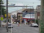
Digital Photograph: Departure of Her Majesty's New Zealand Ship Canterbury…
Images, Canterbury Museum
One landscape colour digital photograph taken on 7 March 2011 showing Her Majesty's New Zealand Ship (HMNZS) Canterbury departing Lyttelton following the completion of her support role in Canterbury following the 22 February 2011 Earthquake. The photograph shows HMNZS Canterbury passing through the Moles out of the Inner Harbour and turning to ...
Digital Photograph: Earthquake damage to the Lyttelton Timeball Station.
Images, Canterbury Museum
One landscape colour digital photograph taken on 16 June 2011 showing the site of the Timeball Station after its collapse. Part of the ground floor remains visible. Photograph taken from Oxford Street Overbridge. Architect The 13 June 2011 earthquakes caused the collapse of the already damaged Lyttelton Timeball Station. After the 22 February ...
Digital Photograph: Earthquake Damage to Lyttelton Roman Catholic and Diss…
Images, Canterbury Museum
One landscape colour digital photograph taken on 30 June 2011 showing earthquake damage to graves in Lyttelton Roman Catholic and Dissenters (Public) Cemeteries in Reserve Terrace. Most of the headstones and grave surrounds in the photograph show damage. Looking east in the Dissenters (Public) section of the cemetery. The Lyttelton cemeteries a...
Digital Photograph: Earthquake Damage to Lyttelton Roman Catholic and Diss…
Images, Canterbury Museum
One landscape colour digital photograph taken on 30 June 2011 showing signs warning of the danger posed by unstable headstones in Lyttelton Roman Catholic and Dissenters (Public) Cemeteries in Reserve Terrace. Several toppled headstones and collapsed grave surrounds are visible in the photograph. Looking east from the main gate. The Lyttelton c...
Digital Photograph: Earthquake damage to St John's Church, Winchester Stre…
Images, Canterbury Museum
One landscape colour digital photograph taken on 25 February 2011 showing earthquake damage to the Presbyterian Church of St John in Winchester Street Lyttelton. Photograph shows the main doors, roof and collapsed tower at southern end of church. Architect St John's Lyttelton was one of the oldest Presbyterian Churches in Canterbury. The New Ze...
Digital Photograph: Her Majesty's New Zealand Ships Canterbury, Otago and …
Images, Canterbury Museum
One landscape colour digital photograph taken on 25 February 2011 showing Her Majesty's New Zealand Ships (HMNZS) (left to right) Pukaki, Otago and Canterbury berthed at Number Seven Wharf in Lyttelton's Inner Harbour. HMNZS Canterbury was tied up in Lyttelton loading New Zealand Army equipment when the magnitude 6.3 earthquake occurred on 22 F...