
Search
found 31 results
Images for earthquake (February 2011); more images...

Digital Photograph: First Responders at the Canterbury Earthquake Memorial…
Images, Canterbury Museum
One landscape colour digital photograph taken 22 February 2017 showing first responders at the Canterbury Earthquake Memorial Service.
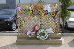
Digital Photograph: Earthquake Memorial Trellis
Images, Canterbury Museum
One landscape colour digital photograph taken 22 February 2017 showing an earthquake memorial trellis at the site of the former Canterbury Television building.
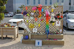
Digital Photograph: Earthquake Memorial Trellis
Images, Canterbury Museum
One landscape colour digital photograph taken 22 February 2017 showing an earthquake memorial trellis at the site of the former Canterbury Television building.
Digital Photograph: Guests Arriving at the Canterbury Earthquake Memorial …
Images, Canterbury Museum
One landscape colour digital photograph taken 22 February 2017 showing guests being seated prior to the Canterbury Earthquake Memorial Service.
Digital Photograph: Members of the Media at the Canterbury Earthquake Memo…
Images, Canterbury Museum
One landscape colour digital photograph taken 22 February 2017 showing cameramen and journalists at the Canterbury Earthquake Memorial Service.
Digital Photograph: Media Viewing Area at the Canterbury Earthquake Memori…
Images, Canterbury Museum
One landscape colour digital photograph taken 22 February 2017 showing the appointed media viewing area at the Canterbury Earthquake Memorial Service.
Digital Photograph: First Responders Laying Wreaths at the Canterbury Eart…
Images, Canterbury Museum
One landscape colour digital photograph taken 22 February 2017 showing first responders laying wreaths at the Canterbury Earthquake Memorial Service.
Digital Photograph: Commemoration Board at the Canterbury Earthquake Memor…
Images, Canterbury Museum
One landscape colour digital photograph taken 22 February 2017 showing a gentleman reading messages on a commemoration board at the Canterbury Earthquake Memorial Service.
Digital Photograph: First Responders and Public Viewing Areas at the Cante…
Images, Canterbury Museum
One landscape colour digital photograph taken 22 February 2017 showing the appointed first responders and public viewing areas at the Canterbury Earthquake Memorial Service.
Digital Photograph: Flowers on an Earthquake Memorial Trellis
Images, Canterbury Museum
One landscape colour digital photograph taken 22 February 2017 showing a bouquet of flowers and a note attached to an earthquake memorial trellis at the site of the former Canterbury Television building.
Digital Photograph: Brass Band at the Canterbury Earthquake Memorial Servi…
Images, Canterbury Museum
One landscape colour digital photograph taken 22 February 2017 showing brass band members at the Canterbury Earthquake Memorial Service. Behind the band is a digital screen showing words of thanks from survivors.
Digital Photograph: Karen Bishop at an Earthquake Memorial Trellis
Images, Canterbury Museum
One landscape colour digital photograph taken 22 February 2017 showing Karen Bishop attaching a windmill to an earthquake memorial trellis in memory of her son Andrew Bishop at the site of the former Canterbury Television building.
Digital Photograph: Brass Band at the Canterbury Earthquake Memorial Servi…
Images, Canterbury Museum
One landscape colour digital photograph taken 22 February 2017 showing brass band members at the Canterbury Earthquake Memorial Service. Behind the band is a digital screen showing an image of flowers floating in the Avon River.
Digital Photograph: Windmill Attached to an Earthquake Memorial Trellis
Images, Canterbury Museum
One landscape colour digital photograph taken 22 February 2017 showing a windmill attached to an earthquake memorial trellis by Karen Bishop in memory of her son Andrew Bishop at the site of the former Canterbury Television building.
Digital Photograph: Flowers Floating in the Avon River
Images, Canterbury Museum
One landscape colour digital photograph taken 22 February 2017 showing flowers floating in the Avon River as part of the Canterbury Earthquake Memorial Service.
Digital Photograph: Sunflower Atop a Road Works Cone
Images, Canterbury Museum
One landscape colour digital photograph taken 22 February 2017 showing a sunflower sitting atop a road works cone as part of the Canterbury Earthquake Memorial Service.
Digital Photograph: Commemorative Note to Andrew Bishop
Images, Canterbury Museum
One landscape colour digital photograph taken 22 February 2017 showing a commemorative note to, and photograph of, Andrew Bishop attached to an earthquake memorial trellis at the site of the former Canterbury Television building.
Digital Photograph: Flowers at the Site of the Former Canterbury Televisio…
Images, Canterbury Museum
One landscape colour digital photograph taken 22 February 2017 showing bouquets of flowers and gifts left at the site of the former Canterbury Television building in memory of earthquake victims.
Digital Photograph: Flowers at the Site of the Former Canterbury Televisio…
Images, Canterbury Museum
One landscape colour digital photograph taken 22 February 2017 showing a bouquet of flowers left at the site of the former Canterbury Television building by the Toyama Language School in memory of earthquake victims.
Digital Photograph: Flowers at the Site of the Former Canterbury Televisio…
Images, Canterbury Museum
One landscape colour digital photograph taken 22 February 2017 showing a bouquet of flowers left at the site of the former Canterbury Television building by St John New Zealand in memory of earthquake victims and in appreciation of first responders.
Music back at the Christchurch Town Hall
Audio, Radio New Zealand
For the first time in six years, music has filled Christchurch's Town Hall, which suffered significant damage in the February 2011 earthquake.
Post earthquake landmark in Christchurch prepares to close
Audio, Radio New Zealand
The Re:Start container mall was one of the first things to pop up in the city's derelict central business district after the February 2011 quake, but now it's preparing to close up shop, as Maja Burry reports.
Fans of The Boss ready themselves for Chch concert tonight
Audio, Radio New Zealand
The sounds of Bruce Springsteen will ring out around Christchurch tonight, ahead of the sixth anniversary of the deadly February 2011 earthquake in the region. Long time fans join us to discuss what they're expecting from tonight's gig.
From darkness comes light: music as a reflection of the lived experience o…
Research papers, University of Canterbury Library
Context of the project: On 4 September 2010, 22 February 2011, 13 June 2011 and 23 December 2011 Christchurch suffered major earthquakes and aftershocks (well over 10,000) that have left the central city in ruins and many of the eastern suburbs barely habitable even now. The earthquakes on 22 February caused catastrophic loss of life with 185 people killed. The toll this has taken on the residents of Christchurch has been considerable, not least of all for the significant psychological impact and disruption it has had on the children. As the process of rebuilding the city commenced, it became clear that the arts would play a key role in maintaining our quality of life during difficult times. For me, this started with the children and the most expressive of all the art forms – music.
Fragility functions for buried pipelines in liquefiable soils based on New…
Research papers, University of Canterbury Library
This poster aims to present fragility functions for pipelines buried in liquefaction-prone soils. Existing fragility models used to quantify losses can be based on old data or use complex metrics. Addressing these issues, the proposed functions are based on the Christchurch network and soil and utilizes the Canterbury earthquake sequence (CES) data, partially represented in Figure 1. Figure 1 (a) presents the pipe failure dataset, which describes the date, location and pipe on which failures occurred. Figure 1 (b) shows the simulated ground motion intensity median of the 22nd February 2011 earthquake. To develop the model, the network and soil characteristics have also been utilized
A comparison of CPT-Vs correlations using a liquefaction case history data…
Research papers, University of Canterbury Library
This study uses 44 high quality liquefaction case histories taken from 22 locations affected by the 2010-2011 Canterbury earthquake sequence to evaluate four commonly used CPT-VS correlations (i.e., Robertson, 2009; Hegazy and Mayne, 2006; Andrus et al., 2007; McGann et al., 2015b). Co-located CPT soundings and VS profiles, developed from surface wave testing, were obtained at 22 locations and case histories were developed for the Mw 7.1, 4 September 2010 Darfield and Mw 6.2, 22 February 2011 Christchurch earthquakes. The CPT soundings are used to generate VS profiles using each of four CPT-VS correlations. These correlated VS profiles are used to estimate the factor of safety against liquefaction using the Kayen et al. (2013) VS-based simplified liquefaction evaluation procedure. An error index is used to quantify the predictive capabilities of these correlations in relation to the observations of liquefaction (or the lack thereof). Additionally, the error indices from the CPT-correlated VS profiles are compared to those obtained using: (1) the Kayen et al. (2013) procedure with surface wave-derived VS profiles, and (2) the Idriss and Boulanger (2008) CPT-based liquefaction evaluation procedure. Based on the error indices, the evaluation procedures based on direct measurements of either CPT or VS provided more accurate liquefaction triggering estimates than those obtained from any of the CPT-VS correlations. However, the performance of the CPT-VS correlations varied, with the Robertson (2009) and Hegazy and Mayne (2006) correlations performing relatively poorly for the Christchurch soils and the Andrus et al. (2007) and McGann et al. (2015b) correlations performing better. The McGann et al. (2015b) correlation had the lowest error indices of the CPT-VS correlations tested, however, none of the CPT-VS correlations provided accurate enough VS predictions to be used for the evaluation of liquefaction triggering using the VS-based liquefaction evaluation procedures.
Alternative Radio : exhibiting radio and music heritage after the Christch…
Research papers, University of Canterbury Library
This article examines the representation of Christchurch, New Zealand, student radio station RDU in the exhibition Alternative Radio at the Canterbury Museum in 2016. With the intention of ‘making visible what is invisible’ about radio broadcasting, the exhibition articulated RDU as a point of interconnection between the technical elements of broadcasting, the social and musical culture of station staff and volunteers, and the broader local and national music scenes. This paper is grounded in observations of the exhibitions and associated public programmes, and interviews with the key participants in the exhibition including the museum's exhibition designer and staff from RDU, who acted as independent practitioners in collaboration with the museum. Alternative Radio also addressed the aftermath of the major earthquake of 22 February 2011, when RDU moved into a customised horse truck after losing its broadcast studio. The exhibition came about because of the cultural resonance of the post-quake story, but also emphasised the long history of the station before that event, and located this small student radio station in the broader heritage discourse of the Canterbury museum, activating the historical, cultural, and personal memories of the station's participants and audiences.
Are athletes on the right track? The effect of availability of an all-weat…
Research papers, University of Canterbury Library
In February of 2011, an earthquake destroyed the only all-weather athletics track in the city of Christchurch (New Zealand). The track has yet to be replaced, and so since the loss of the track, local Christchurch athletes have only had a grass track for training and preparation for championship events. This paper considers what effect the loss of the training facility has had on the performance of athletes from Christchurch at national championship events. Not surprisingly, the paper finds that there has been a deterioration in the performance in events that are heavily dependent upon the all-weather surface. However, somewhat more surprisingly, the loss of the track appears to have caused a significant improvement in the performance of Christchurch athletes in events that, while on the standard athletics program, are not heavily track dependent.
Planning for resilient communities: and every other day: learning from the…
Research papers, University of Canterbury Library
After a disaster, cities experience profound social and environmental upheaval. Current research on disasters describes this social disruption along with collective community action to provide support. Pre-existing social capital is recognised as fundamental to this observed support. This research examines the relationship between sense of place for neighbourhood, social connectedness and resilience. Canterbury residents experienced considerable and continued disruption following a large and protracted sequence of earthquakes starting in September 2010. A major aftershock on 22 February 2011 caused significant loss of life, destruction of buildings and infrastructure. Following this earthquake some suburbs of Christchurch showed strong collective action. This research examines the features of the built environment that helped to form this cooperative support. Data were collected through semi-structured interviews with 20 key informants followed by 38 participants from four case study suburbs. The objectives were to describe the community response of suburbs, to identify the key features of the built environment and the role of social infrastructure in fostering social connectedness. The last objective was to contribute to future planning for community resilience. The findings from this research indicated that social capital and community competence are significant resources to be called upon after a disaster. Features of the local environment facilitated the formation of neighbourhood connections that enabled participants to cope, manage and to collectively solve problems. These features also strengthened a sense of belonging and attachment to the home territory. Propinquity was important; the bumping and gathering places such as schools, small local shops and parks provided the common ground for meaningful pre-existing local interaction. Well-defined geography, intimate street typology, access to quality natural space and social infrastructure helped to build the local social connections and develop a sense of place. Resourceful individuals and groups were also a factor, and many are drawn to live near the inner city or more natural places. The features are the same well understood attributes that contribute to health and wellbeing. The policy and planning framework needs to consider broader social outcomes, including resilience in new and existing urban developments. The socio-political structures that provide access to secure and stable housing and local education should also be recognised and incorporated into local planning for resilience and the everyday.
Liquefaction evaluation in stratified soils.
Research papers, University of Canterbury Library
The Canterbury Earthquake Sequence (CES) of 2010-2011 caused widespread liquefaction in many parts of Christchurch. Observations from the CES highlight some sites were liquefaction was predicted by the simplified method but did not manifest. There are a number of reasons why the simplified method may over-predict liquefaction, one of these is the dynamic interaction between soil layers within a stratified deposit. Soil layer interaction occurs through two key mechanisms; modification of the ground motion due to seismic waves passing through deep liquefied layers, and the effect of pore water seepage from an area of high excess pore water pressure to the surrounding soil. In this way, soil layer interaction can significantly alter the liquefaction behaviour and surface manifestation of soils subject to seismic loading. This research aimed to develop an understanding of how soil layer interaction, in particular ground motion modification, affects the development of excess pore water pressures and liquefaction manifestation in a soil deposit subject to seismic loading. A 1-D soil column time history Effective Stress Analysis (ESA) was conducted to give an in depth assessment of the development of pore pressures in a number of soil deposits. For this analysis, ground motions, soil profiles and model parameters were required for the ESA. Deconvolution of ground motions recorded at the surface during the CES was used to develop some acceleration time histories to input at the base of the soil-column model. An analysis of 55 sites around Christchurch, where detailed site investigations have been carried out, was then conducted to identify some simplified soil profiles and soil characteristics. From this analysis, four soil profiles representative of different levels of liquefaction manifestation were developed. These were; two thick uniform and vertically continuous sandy deposits that were representative of sites were liquefaction manifested in both the Mw 7.1 September 2010 and the Mw 6.3 February 2011 earthquakes, and two vertically discontinuous profiles with interlayered liquefiable and non-liquefiable layers representative of sites that did not manifest liquefaction in either the September 2010 or the February 2011 events. Model parameters were then developed for these four representative soil profiles through calibration of the constitutive model in element test simulations. Simulations were run for each of the four profiles subject to three levels of loading intensity. The results were analysed for the effect of soil layer interaction. These were then compared to a simplified triggering analysis for the same four profiles to determine where the simplified method was accurate in predicting soil liquefaction (for the continuous sandy deposits) and were it was less accurate (the vertically discontinuous deposits where soil layer interaction was a factor).
- 1
- »