Search
found 11 results
Images for cause; more images...


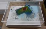
3-D Model: Port Hills Faults
Images, Canterbury Museum
One oblong perspex covered 3-D model of the fault plains that ruptured to cause the 22 February and 13 June 2011 earthquakes; top of the model also acts as a map overlay. This model provides a visual demonstration of the geological forces that caused the 22 February and 13 June 2011 earthquakes. These forces were so strong that parts of the Por...
Book: Christchurch 22.2: Beyond the Cordon
Images, Canterbury Museum
One black hardcover book with a multi-coloured dust jacket depicting men in uniform amongst rubble entitled 'Christchurch 22.2: Beyond the Cordon' containing colour photographs by the New Zealand Police following the 22 February 2011 earthquake. The severe damage to Christchurch’s central city caused by the 22 February 2011 earthquake is unique...
Digital Photograph: Red brick fence
Images, Canterbury Museum
One landscape colour digital photograph taken on 6 September 2010 showing earthquake damage to a red brick fence on Bealey Avenue. Unreinforced brick masonry was particularly susceptible to damage during the 2010-2011 Canterbury earthquakes. Walls and fences constructed from on many properties were shaken loose causing piles of rubble to litter...
Book: Trapped, Remarkable Stories of Survival from the 2011 Canterbury Ear…
Images, Canterbury Museum
One multi-coloured softcover book titled 'Trapped' by Martin van Beynen with colour illustrations and maps. Collected experiences of some of those trapped following the 22 February earthquake. Mainstream media coverage of the 22 February 2011 earthquake understandably focussed on the devastating damage and loss of life caused by the earthquake....
Digital Photograph: Van outside Christchurch Chinese Methodist Church
Images, Canterbury Museum
One landscape colour digital photograph taken on 6 September 2010 showing earthquake damage to a van caused by red bricks from the Christchurch Chinese Methodist Church, 165 Papanui Road. The Christchurch Chinese Methodist Church on Papanui Road sustained severe damage during the 4 September 2010 earthquake. Constructed from unreinforced red br...
Book: The Big Quake, Canterbury September 4, 2010
Images, Canterbury Museum
Multicolour softcover book titled "The Big Quake, Canterbury September 4, 2010" by The Press; colour illustrations and maps; accompanying DVD. The extent of the damage caused by the 4 September 2010 earthquake is recorded in this book by Christchurch’s daily newspaper The Press. The overall message portrayed is one of community spirit and a com...
Digital Photograph: Liquefaction in Hagley Park
Images, Canterbury Museum
One landscape colour digital photograph taken on 6 September 2010 showing liquefaction in Hagley Park. Liquefaction is the name of the process where water pushes sand and silt above ground. These puddles of sand and silt are left above ground. Liquefaction caused huge problems when it occurred in residential suburbs as was as likely to push thr...
Digital Photograph: Godley Head
Images, Canterbury Museum
One landscape colour digital photograph taken on 26 May 2013 showing the southern cliffs of Godley Head, taken from the middle of the shipping channel. Some earthquake damage to the cliffs is visible. There were several major rock falls along the coastal cliffs near Christchurch and Lyttelton Harbour. At Godley Head these caused damage to the ...
Digital Photograph: Earthquake damage to the Lyttelton Timeball Station.
Images, Canterbury Museum
One landscape colour digital photograph taken on 16 June 2011 showing the site of the Timeball Station after its collapse. Part of the ground floor remains visible. Photograph taken from Oxford Street Overbridge. Architect The 13 June 2011 earthquakes caused the collapse of the already damaged Lyttelton Timeball Station. After the 22 February ...
Digital Photograph: Earthquake damage to searchlight emplacements, Godley …
Images, Canterbury Museum
One landscape colour digital photograph taken on 26 May 2013 showing the southern cliffs of Godley Head. Taken from the middle of the shipping channel. Some earthquake damage to the cliffs is visible. There were several major rock falls along the coastal cliffs near Christchurch and Lyttelton Harbour. At Godley Head these caused damage to the W...
Were there real precursors of the Christchurch Earthquake?
Manuscripts, Alexander Turnbull Library
A preliminary report with findings from an internet survey conducted in the Christchurch region in the days following the Darfield earthquake. Includes eyewitness accounts of alleged earthquake precursors, such as earthquake lights, atmospheric changes, human responses and erratic animal behaviour. Quantity: 1 Electronic document(s). Provenance: The donor provided the following information: In connection with the M7.1 earthquake at Darfield, September 4th, we collected many accounts of alleged precursors via an internet survey. The resulting report is attached. It is an interesting historical document and you might consider adding it to the National LIbrary collection in some form. About 100 copies have been distributed to those who asked for it. There is no official printed form, it is digital only. The report forms the basis of a scientific paper in preparation but it is already apparent that much of the quoted accounts from survey respondents will have to be left out. The report itself will therefore remain a useful document. We plan to submit the scientific paper to Natural Hazards and Earth Science Systems in due course. The report and paper confirm that some real precursors do exist, but cannot be more specific about causes.
- 1