Search
found 14 results
Images for South Island; more images...


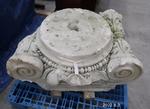
Column capital: Ionic
Images, Canterbury Museum
One limestone column capital, Ionic style. Leaf design on the volutes/scrolls. Salvaged during the demolition of the Cathedral of the Blessed Sacrament, Barbadoes Street, Christchurch.
Clock: Christchurch Railway Station
Images, Canterbury Museum
One cast iron and perspex turret clock dial with two hands. Originally from the tower of the Christchurch railway station building on Moorehouse Avenue, which later became the science education centre Science Alive!
Clock: Christchurch Railway Station
Images, Canterbury Museum
One cast iron and perspex turret clock dial with two hands. Originally from the tower of the Christchurch railway station building on Moorehouse Avenue, which later became the science education centre Science Alive!
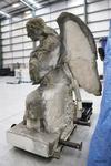
Angel: Cathedral of the Blessed Sacrament
Images, Canterbury Museum
One limestone angel kneeling with left knee raised. Salvaged from atop the entrance of the Cathedral of the Blessed Sacrament, Barbadoes Street, Christchurch, before the Cathedral was demolished due to damage from the Christchurch earthquakes of 2010/11.
Angel: Cathedral of the Blessed Sacrament
Images, Canterbury Museum
One limestone angel kneeling with right knee raised. Salvaged from atop the entrance of the Cathedral of the Blessed Sacrament, Barbadoes Street, Christchurch, before the Cathedral was demolished due to damage from the Christchurch earthquakes of 2010/11.
Road Closed
Images, eqnz.chch.2010
Earthquake damaged building on a Walk around the city, May 1, 2014 Christchurch New Zealand. Demolition work on Christchurch's "distinctive" former civic building is under way. The category-2 heritage building was designed by G A J Hart and opened in 1939 as the Miller's department store. It featured the South Island's first escalator, which...
Just a Shell of Its Self
Images, eqnz.chch.2010
Earthquake damaged building on a Walk around the city, May 1, 2014 Christchurch New Zealand. Demolition work on Christchurch's "distinctive" former civic building is under way. The category-2 heritage building was designed by G A J Hart and opened in 1939 as the Miller's department store. It featured the South Island's first escalator, which...
Storm on the Way
Images, eqnz.chch.2010
On a walk around the city to catch up on what is happening May 29, 2014 Christchurch New Zealand. Demolition work on Christchurch's "distinctive" former civic building is under way. The category-2 heritage building was designed by G A J Hart and opened in 1939 as the Miller's department store. It featured the South Island's first escalator, w...
Critical Infrastructure Impacts in Small Towns Following the Kaikoura Eart…
Research papers, University of Canterbury Library
Background and methodology The Mw 7.8, 14th November 2016 earthquake centred (item b, figure 1) in the Hurunui District of the South Island, New Zealand, damaged critical infrastructure across North Canterbury and Marlborough. We investigate the impacts to infrastructure and adaptations to the resulting service disruption in four small rural towns (figure 1): Culverden (a), Waiau (c), Ward (d) and Seddon (e). This is accomplished though literary research, interviews and geospatial analysis. Illustrating our methods, we have displayed here a Hurunui District hazard map (figure 2b) and select infrastructure inventories (figures 2a, 3).
Disestablishing “Glacial Lake Speight”, New Zealand? An example for the va…
Research papers, University of Canterbury Library
Detailed studies on the sediment budget may reveal valuable insights into the successive build-up of the Canterbury Plains and their modification by Holocene fluvialaction connected to major braided rivers. Additionally, they bear implications beyond these fluvial aspects. Palaeoseismological studies claim to have detected signals of major Alpine Fault earthquakes in coastal environments along the eastern seaboard of the South Island (McFadgen and Goff, 2005). This requires high connectivity between the lower reaches of major braided rivers and their mountain catchments to generate immediate significant sediment pulses. It would be contradictory to the above mentioned hypothesis though. Obtaining better control on sediment budgets of braided rivers like the Waimakariri River will finally add significant value to multiple scientific and applied topics like regional resource management. An essential first step of sediment budget studies Is to systematically map the geomorphology, conventionally in the field and/or using remote-sensing applications, to localise, genetically identify, and classify landforms or entire toposequences of the area being investigated. In formerly glaciated mountain environments it is also indispensable to obtain all available chronological information supporting subsequent investigations.
3D Ground Motion Simulations for the Christchurch Area Including the Surfa…
Research papers, University of Canterbury Library
We present initial results from a set of three-dimensional (3D) deterministic earthquake ground motion simulations for the northern Canterbury plains, Christchurch and the Banks Peninsula region, which explicitly incorporate the effects of the surface topography. The simu-lations are done using Hercules, an octree-based finite-element parallel software for solving 3D seismic wave propagation problems in heterogeneous media under kinematic faulting. We describe the efforts undertaken to couple Hercules with the South Island Velocity Model (SIVM), which included changes to the SIVM code in order to allow for single repetitive que-ries and thus achieve a seamless finite-element meshing process within the end-to-end ap-proach adopted in Hercules. We present our selection of the region of interest, which corre-sponds to an area of about 120 km × 120 km, with the 3D model reaching a depth of 60 km. Initial simulation parameters are set for relatively high minimum shear wave velocity and a low maximum frequency, which we are progressively scaling up as computing resources permit. While the effects of topography are typically more important at higher frequencies and low seismic velocities, even at this initial stage of our efforts (with a maximum of 2 Hz and a mini-mum of 500 m/s), it is possible to observe the importance of the topography in the response of some key locations within our model. To highlight these effects we compare the results of the 3D topographic model with respect to those of a flat (squashed) 3D model. We draw rele-vant conclusions from the study of topographic effects during earthquakes for this region and describe our plans for future work.
Ground Motion Simulation Validation using Small-to-Moderate Magnitude Even…
Research papers, University of Canterbury Library
This poster presents work to date on ground motion simulation validation and inversion for the Canterbury, New Zealand region. Recent developments have focused on the collection of different earthquake sources and the verification of the SPECFEM3D software package in forward and inverse simulations. SPECFEM3D is an open source software package which simulates seismic wave propagation and performs adjoint tomography based upon the spectral-element method. Figure 2: Fence diagrams of shear wave velocities highlighting the salient features of the (a) 1D Canterbury velocity model, and (b) 3D Canterbury velocity model. Figure 5: Seismic sources and strong motion stations in the South Island of New Zealand, and corresponding ray paths of observed ground motions. Figure 3: Domain used for the 19th October 2010 Mw 4.8 case study event including the location of the seismic source and strong motion stations. By understanding the predictive and inversion capabilities of SPECFEM3D, the current 3D Canterbury Velocity Model can be iteratively improved to better predict the observed ground motions. This is achieved by minimizing the misfit between observed and simulated ground motions using the built-in optimization algorithm. Figure 1 shows the Canterbury Velocity Model domain considered including the locations of small-to-moderate Mw events [3-4.5], strong motion stations, and ray paths of observed ground motions. The area covered by the ray paths essentially indicates the area of the model which will be most affected by the waveform inversion. The seismic sources used in the ground motion simulations are centroid moment tensor solutions obtained from GeoNet. All earthquake ruptures are modelled as point sources with a Gaussian source time function. The minimum Mw limit is enforced to ensure good signal-to-noise ratio and well constrained source parameters. The maximum Mw limit is enforced to ensure the point source approximation is valid and to minimize off-fault nonlinear effects.
Quantifying Road Criticality through the Impact of Disruptions due to Natu…
Research papers, The University of Auckland Library
Road networks are highly exposed to natural hazard events, which can lead to significant economic and social consequences. In New Zealand, events such as the 2011 Christchurch earthquake, the 2016 Kaikōura earthquake, and the Cyclone Gabrielle in 2023 have demonstrated the severe consequences of road network disruptions. Traditional post event economic assessments often focus solely on clean-up and repair costs, neglecting the broader and more enduring impacts these events can have. Furthermore, business cases for resilience investments usually fail when quantifying the economic benefits of mitigation strategies, due to the underestimation of road disruption consequences. Importantly, not all road link disruptions contribute equally to these consequences, making the identification of critical road links a key step in resilience focused investment prioritization. Furthermore, traditional transportation asset management typically evaluates the life cycle of roads under normal conditions, such as traffic loads and standard environmental factors, while neglecting the influence of natural hazards. However, these events can significantly alter road deterioration and increase maintenance costs, emphasizing the need for integrating risk and resilience into transportation asset management approaches. This thesis presents a methodology to evaluate road criticality by assessing the economic consequences of road disruptions in combination with a hazard model in a prioritization index. Initially, the consequences are quantified through increased travel time, higher vehicle operating costs, and increased gas emissions. Thereafter, a new consequence model is introduced to estimate the increase in maintenance costs on alternative routes that absorb diverted traffic following a disruption. These consequence models are initially applied in a 'full-scan' analysis approach, where each road link is removed in turn to quantify its potential impact and, therefore, its criticality. Subsequently, a hazard model is integrated to develop a road prioritization index that combines the expected impacts of road disruptions, the individual road link criticality, and the probability of occurrence of natural hazard events. This index is designed to help road agencies in prioritizing mitigation strategies. Furthermore, the proposed methodology can also be applied to quantify the indirect economic impacts of natural hazard events. The methodology is demonstrated using New Zealand’s South Island inter-urban network as a case study, incorporating an earthquake-induced landslide model, with Python based simulations, providing road agencies a valuable tool to quantify the economic benefits of resilience investments
Alluvial fan response to Alpine Fault earthquakes on the Westland piedmont…
Research papers, Lincoln University
We examined the stratigraphy of alluvial fans formed at the steep range front of the Southern Alps at Te Taho, on the north bank of the Whataroa River in central West Coast, South Island, New Zealand. The range front coincides with the Alpine Fault, an Australian-Pacific plate boundary fault, which produces regular earthquakes. Our study of range front fans revealed aggradation at 100- to 300-year intervals. Radiocarbon ages and soil residence times (SRTs) estimated by a quantitative profile development index allowed us to elucidate the characteristics of four episodes of aggradation since 1000 CE. We postulate a repeating mode of fan behaviour (fan response cycle [FRC]) linked to earthquake cycles via earthquake-triggered landslides. FRCs are characterised by short response time (aggradation followed by incision) and a long phase when channels are entrenched and fan surfaces are stable (persistence time). Currently, the Te Taho and Whataroa River fans are in the latter phase. The four episodes of fan building we determined from an OxCal sequence model correlate to Alpine Fault earthquakes (or other subsidiary events) and support prior landscape evolution studies indicating ≥M7.5 earthquakes as the main driver of episodic sedimentation. Our findings are consistent with other historic non-earthquake events on the West Coast but indicate faster responses than other earthquake sites in New Zealand and elsewhere where rainfall and stream gradients (the basis for stream power) are lower. Judging from the thickness of fan deposits and the short response times, we conclude that pastoral farming (current land-use) on the fans and probably across much of the Whataroa River fan would be impossible for several decades after a major earthquake. The sustainability of regional tourism and agriculture is at risk, more so because of the vulnerability of the single through road in the region (State Highway 6).
- 1