Search
found 68 results
Images for Faults (Geology); more images...

The Hope Fault at Hossack Station east of Hanmer Basin, North Canterbury
Research papers, University of Canterbury Library
Oblique convergence of the Pacific and Australian Plates is accommodated in the northern South Island by the Marlborough Fault System. The Hope Fault is the southern of four major dextral strike-slip faults of this system. Hanmer Basin is a probable segment boundary between the Hope River and Conway segments of the Hope Fault. The Conway segment is transpressional and shows increasing structural complexity near the segment boundary at Hanmer Basin, with multiple Late Quaternary traces, and fault-parallel folding in response to across-fault shortening. Between Hossack Station and Hanmer Basin a crush zone in excess of one kilometre wide is exposed in incised streams and rivers. The crush zone has an asymmetrical geometry about the active trace of the Hope Fault, being only 100-300 metres wide south of the fault, and more than 500 metres wide north of the fault. The most intense deformation of Torlesse bedrock occurs at the south side of the fault zone, indicating that strain is accommodated against the fault footwall. North of the fault deformation is less intense, but occurs over a wider area. The wide fault zone at Hossack Station may reflect divergence of the Hanmer Fault, a major splay of the Hope Fault. At Hossack Station, the Hope Fault has accommodated at least 260 metres of dextral displacement during the Holocene. Dating of abandoned stream channels, offset by the Hope Fault, indicated a Late Holocene dextral slip-rate of 18±8 mm-¹ for the west end of the Conway segment. Using empirical formulae and inferred fault parameters, the expected magnitude of an earthquake generated by the Conway segment is M6.9 to M7.4; for an exceedence probability of 10%, the magnitude is M7.7 to M7.9. Effects associated with coseismic rupture of the Conway segment include shaking of up to MMIX along the ruptured fault and at Hanmer Basin. Uplift at the east end of Hanmer Basin, in conjunction with subsidence at the southwest margin of the basin, is resulting in the development of onlapping stratigraphy. Seismic reflection profiles support this theory. Possible along-fault migration of the basin is inferred to be a consequence of non-parallelism of the master faults.
The landscape record of blind fault earthquakes
Research papers, University of Canterbury Library
Active faults capable of generating highly damaging earthquakes may not cause surface rupture (i.e., blind faults) or cause surface ruptures that evade detection due to subsequent burial or erosion by surface processes. Fault populations and earthquake frequency-‐magnitude distributions adhere to power laws, implying that faults too small to cause surface rupture but large enough to cause localized strong ground shaking densely populate continental crust. The rupture of blind, previously undetected faults beneath Christchurch, New Zealand in a suite of earthquakes in 2010 and 2011, including the fatal 22 February 2011 moment magnitude (Mw) 6.2 Christchurch earthquake and other large aftershocks, caused a variety of environmental impacts, including major rockfall, severe liquefaction, and differential surface uplift and subsidence. All of these effects occurred where geologic evidence for penultimate effects of the same nature existed. To what extent could the geologic record have been used to infer the presence of proximal, blind and / or unidentified faults near Christchurch? In this instance, we argue that phenomena induced by high intensity shaking, such as rock fragmentation and rockfall, revealed the presence of proximal active faults in the Christchurch area prior to the recent earthquake sequence. Development of robust earthquake shaking proxy datasets should become a higher scientific priority, particularly in populated regions.
Seismic hazard associated with the Springbank Fault, North Canterbury Plans
Research papers, University of Canterbury Library
This study contains an evaluation of the seismic hazard associated with the Springbank Fault, a blind structure discovered in 1998 close to Christchurch. The assessment of the seismic hazard is approached as a deterministic process in which it is necessary to establish: 1) fault characteristics; 2) the maximum earthquake that the fault is capable of producing and 3) ground motions estimations. Due to the blind nature of the fault, conventional techniques used to establish the basic fault characteristics for seismic hazard assessments could not be applied. Alternative methods are used including global positioning system (GPS) surveys, morphometric analyses along rivers, shallow seismic reflection surveys and computer modelling. These were supplemented by using multiple empirical equations relating fault attributes to earthquake magnitude, and attenuation relationships to estimate ground motions in the near-fault zone. The analyses indicated that the Springbank Fault is a reverse structure located approximately 30 km to the northwest of Christchurch, along a strike length of approximately 16 km between the Eyre and Ashley River. The fault does not reach the surface, buy it is associated with a broad anticline whose maximum topographic expression offers close to the mid-length of the fault. Two other reverse faults, the Eyrewell and Sefton Faults, are inferred in the study area. These faults, together with the Springbank and Hororata Faults and interpreted as part of a sys of trust/reverse faults propagating from a decollement located at mid-crustal depths of approximately 14 km beneath the Canterbury Plains Within this fault system, the Springbank Fault is considered to behave in a seismically independent way, with a fault slip rate of ~0.2 mm/yr, and the capacity of producing a reverse-slip earthquake of moment magnitude ~6.4, with an earthquake recurrence of 3,000 years. An earthquake of the above characteristics represents a significant seismic hazard for various urban centres in the near-fault zone including Christchurch, Rangiora, Oxford, Amberley, Kaiapoi, Darfield, Rollestion and Cust. Estimated peak ground accelerations for these towns range between 0.14 g to 0.5 g.
Morphostructural and paleo-seismic analysis of fault interactions in the O…
Research papers, University of Canterbury Library
This study investigates evidence for linkages and fault interactions centred on the Cust Anticline in Northwest Canterbury between Starvation Hill to the southwest and the Ashley and Loburn faults to the northeast. An integrated programme of geologic, geomorphic, paleo-seismic and geophysical analyses was undertaken owing to a lack of surface exposures and difficulty in distinguishing active tectonic features from fluvial and/or aeolian features across the low-relief Canterbury Plains. LiDAR analysis identified surface expression of several previously unrecognised active fault traces across the low-relief aggradation surfaces of the Canterbury Plains. Their presence is consistent with predictions of a fault relay exploiting the structural mesh across the region. This is characterised by interactions of northeast-striking contractional faults and a series of re-activating inherited Late Cretaceous normal faults, the latter now functioning as E–W-striking dextral transpressive faults. LiDAR also allowed for detailed analysis of the surface expression of individual faults and folds across the Cust Anticline contractional restraining bend, which is evolving as a pop-up structure within the newly established dextral shear system that is exploiting the inherited, now re-activated, basement fault zone. Paleo-seismic trenches were located on the crest of the western arm of the Cust Anticline and across a previously unrecognised E–W-striking fault trace, immediately southwest of the steeply plunging Cust Anticline termination. These studies confirmed the location and structural style of north-northeast-striking faults and an E–W-striking fault associated with the development of this structural culmination. A review of available industry seismic reflection lines emphasised the presence of a series of common structural styles having the same underlying structural drivers but with varying degrees of development and expression, both in the seismic profiles and in surface elevations across the study area. Based on LiDAR surface mapping and preliminary re-analysis of industry seismic reflection data, four fault zones are identified across the restraining bend structural culminations, which together form the proposed Oxford–Cust–Ashley Fault System. The 2010–2012 Canterbury Earthquake Sequence showed many similarities to the structural pattern established across the Oxford–Cust–Ashley Fault System, emphasising the importance of identification and characterization of presently hidden fault sources, and the understanding of fault network linkages, in order to improve constraints on earthquake source potential. Improved understanding of potentially-interactive fault sources in Northwest Canterbury, with the potential for combined initial fault rupture and spatial and temporal rupture propagation across this fault system, can be used in probabilistic seismic hazard analysis for the region, which is essential for the suitability and sustainability of future social and economic development.
An evaluation of the late Quaternary displacements and seismic hazard asso…
Research papers, University of Canterbury Library
The Amuri Earthquake of September 1, 1888 (magnitude M = 6.5 to 6.8) occurred on the Hope River Segment of the Hope Fault west of Hanmer Plains. The earthquake was felt strongly in North Canterbury and North Westland and caused considerable property damage and landsliding in the Lower Hope Valley. However, damage reports and the spatial distribution of felt intensities emphasize extreme variations in seismic effects over short distances, probably due to topographic focusing and local ground conditions. Significant variations in lateral fault displacement occurred at secondary fault segment boundaries (side-steps and bends in the fault trace) during the 1888 earthquake. This historical spatial variation in lateral slip is matched by the Late Quaternary geomorphic distribution of slip on the Hope River Segment of the Hope Fault. Trenching studies at two sites on the Hope Fault have also identified evidence for five pre-historic earthquakes of similar magnitude to the 1888 earthquake and an average recurrence interval of 134 ± 27 years between events. Magnitude estimates for the 1888 earthquake are combined with a. strong ground motion attenuation expression to provide an estimate of potential ground accelerations in Amuri District during-future earthquakes on the Hope River Segment of the Hope Fault. The predicted acceleration response on bedrock sites within 20 km of the epicentral region is between 0.23 g and 0.34 g. The close match between the historic, inferred pre-historic and geomorphic distribution of lateral slip indicates that secondary fault segmentation exerts a strong structural control on rupture propagation and the expression of fault displacement at the surface. In basement rocks at depth the spatial variations in slip are inferred to be distributed within zones of pervasive cataclastic shear, on either side of the fault segment boundaries. The large variations in surface displacement across fault segment boundaries means that one must know the geometry of the fault in order to evaluate slip-rates calculated from individual locations. The average Late Quaternary slip-rate on the Hope Fault at Glynn Wye Station is between 15.5 mm/yr and 18.25 mm/yr and the rate on the subsidiary Kakapo Fault is between 5.0 mm/yr and 7.5 mm/yr. These rates have been determined from sites which are relatively free of structural complication.
Patterns of Crustal Deformation Resulting from the 2010 Earthquake Sequenc…
Research papers, University of Canterbury Library
The Mw 7.1 Darfield earthquake generated a ~30 km long surface rupture on the Greendale Fault and significant surface deformation related to related blind faults on a previously unrecognized fault system beneath the Canterbury Plains. This earthquake provided the opportunity for research into the patterns and mechanisms of co-seismic and post-seismic crustal deformation. In this thesis I use multiple across-fault EDM surveys, logic trees, surface investigations and deformation feature mapping, seismic reflection surveying, and survey mark (cadastral) re-occupation using GPS to quantify surface displacements at a variety of temporal and spatial scales. My field mapping investigations identified shaking and crustal displacement-induced surface deformation features south and southwest of Christchurch and in the vicinity of the projected surface traces of the Hororata Blind and Charing Cross Faults. The data are consistent with the high peak ground accelerations and broad surface warping due to underlying reverse faulting on the Hororata Blind Fault and Charing Cross Fault. I measured varying amounts of post-seismic displacement at four of five locations that crossed the Greendale Fault. None of the data showed evidence for localized dextral creep on the Greendale Fault surface trace, consistent with other studies showing only minimal regional post-seismic deformation. Instead, the post-seismic deformation field suggests an apparent westward translation of northern parts of the across-fault surveys relative to the southern parts of the surveys that I attribute to post-mainshock creep on blind thrusts and/or other unidentified structures. The seismic surveys identified a deformation zone in the gravels that we attribute to the Hororata Blind Fault but the Charing Cross fault was not able to be identified on the survey. Cadastral re-surveys indicate a deformation field consistent with previously published geodetic data. We use this deformation with regional strain rates to estimate earthquake recurrence intervals of ~7000 to > 14,000 yrs on the Hororata Blind and Charing Cross Faults.
The Porters Pass fault
Research papers, University of Canterbury Library
A zone of active tectonism occurs in mid and north Canterbury, from the Rakaia to the Waipara Rivers, which coincides with seismicity concentrations and several Quaternary surface anomalies and is here defined as the Porters Pass Tectonic Zone. Although parallel to the Marlborough faults to the north, the lack of regional definition suggests this zone is much younger in its inception reflecting a southward movement of the plate rotation vector. The objectives of this study were to map the structures associated with this zone in the segment between the Rakaia and Waimakariri Rivers with detailed analysis concentrated in the upper Kawai Valley. Quaternary offsets on the main lineament of the Porters Pass Fault were traced through the area and evidence for the rate of movement, probable magnitudes and return periods of related seismic events was sought. The basement was found to be complicated by pre-existing deformation structures in Torlesse Group rocks which have been subsequently been re-activated or rotated by recent fault movement probably beginning in the Pleistocene. This phase is dominantly thrusting and uplift has lead to the erosion of most of the overlying sedimentary cover. Remnants of the Cret-Tertiary sediments still remain as fault-bounded packets. Evidence suggests that a change to development of a regional lateral shear associated with the Porters Pass Tectonic Zone transects the thrust system with complex interaction between the older reverse and new strike-slip faults. Offset rates along the segments of the Porters Pass Fault are not well constrained but are believed to be approximately in the range of 11-13 mm/year for at least the last 130,000 years. This rate is similar to other large faults in the Marlborough region. Two earthquake events have been identified and dated at 600 and 2000 years ago, with a magnitude of greater than 6.5. Evidence suggests characteristic earthquakes along the Porters Pass Fault are greater than Magnitude 7. This result has some major ramifications for the expected seismic hazards for nearby Christchurch.
Holocene surface-faulting earthquakes along the Porters Pass fault
Research papers, University of Canterbury Library
The Porters Pass fault (PPF) is a prominent element of the Porters Pass-Amberley Fault Zone (PPAFZ) which forms a broad zone of active earth deformation ca 100 km long, 60-90 km west and north of Christchurch. For a distance of ca 40 km the PPF is defined by a series of discontinuous Holocene active traces between the Rakaia and Waimakariri Rivers. The amount of slip/event and the timing of paleoearthquakes are crucial components needed to estimate the earthquake potential of a fault. Movement was assumed to be, coseismic and was quantified by measuring displaced geomorphic features using either tape measure or surveying equipment. Clustering of offset data suggests that four to five earthquakes occurred on the PPF during the Holocene and these range between ca 5-7 m/event. Timing information was obtained from four trenches excavated across the fault and an auger adjacent to the fault. Organic samples from these sites were radiocarbon dated and used in conjunction with data from previous studies to identify the occurrence of at least four earthquakes at 8500 ± 200, 5300 ± 700, 2500 ± 200 and 1000 ± 100 years B.P. Evidence suggests that an additional event is also possible at 6200 ± 500 years B.P. The ~1000, 5300 and 6200 years B.P. paleoearthquakes were previously unrecognised, while the 500 year event previously inferred from rock-avalanche data has been discarded. The present data set produces recurrence intervals of ~2000-2500 years for the Holocene. The identification of only one Holocene PPF rupture to the west of Red Lakes indicates the presence of a segment boundary that prevents the propagation of rupture beyond this point. This is consistent with displacement data and results in slip rates of 0.5-0.7 mm/yr and 2.5-3.4 mm/yr to the west and east of Red Lakes respectively. It is possible that the nearby extensional Red Hill Fault influences PPF rupture propagation. The combination of geometric, slip rate and timing data has enabled the magnitude of prehistoric earthquakes on the PPF to be estimated. These magnitudes range from an average of between 6.9 for a fault rupture from Waimakariri River to Red Lakes, to a maximum of 7.4 that ruptures the entire length of the PPAFZ, including the full length of the PPF. These estimates are approximately consistent with previous magnitude estimates along the full length of the PPAFZ of between 7.0 and 7.5.
Preliminary insights into the fault geometries and kinematics of surface r…
Research papers, University of Canterbury Library
The south Leader Fault (SLF) is a newly documented active structure that ruptured the surface during the Mw 7.8 Kaikoura earthquake. The Leader Fault is a NNE trending oblique left lateral thrust that links the predominantly right lateral ‘The Humps’ and Conway-Charwell faults. The present research uses LiDAR at 0.5 m resolution and field mapping to determine the factors controlling the surface geometries and kinematics of the south Leader Fault ruptures at the ground surface. The SLF zone is up to 2km wide and comprises a series of echelon NE-striking thrusts linked by near-vertical N-S striking faults. The thrusts are upthrown to the west by up to 1 m and dip 35-45°. Thrust slip surfaces are parallel with Cretaceous-Cenozoic bedding and may reflect flexural slip folding. By contrast, the northerly striking faults dip steeply (65° west- 85° east), and accommodate up to 3m of oblique left lateral displacement at the ground surface and displace Cenozoic bedding. Some of the SLF has been mapped in bedrock, although none were known to be active prior to the earthquake or have a strong topographic expression. The complexity of fault rupture and the width of the fault zone appears to reflect the occurrence of faulting and folding at the ground surface during the earthquake.
Assessment of active fault and fold hazards in the Twizel area, Mackenzie …
Articles, UC QuakeStudies
This report provided information on the location and character of the Ostler Fault Zone near Twizel. The fault traces, and associated recommended fault avoidance zones, were mapped in detail for inclusion in a District Plan Change for the Twizel area. The Ostler Fault Zone was mapped in detail because of the higher likelihood of movement on that fault than others in the district, and the potential for future development across the fault zone because of its proximity to Twizel. See Object Overview for background and usage information. The report recommended that the information be incorporated into the District Plan Change and that site-specific investigations be undertaken before development is allowed within the fault avoidance zones. These recommendations were taken up by Mackenzie District Council.
Greendale Fault: investigation of surface rupture characteristics for faul…
Articles, UC QuakeStudies
The previously unknown Greendale Fault ruptured to the ground surface, causing up to 5 metres horizontal and 1 metre vertical permanent offset of the ground, during the September 2010 Darfield (Canterbury) earthquake. Environment Canterbury commissioned GNS Science, with help from the University of Canterbury, to define a fault avoidance zone and to estimate the fault recurrence interval. There is little evidence for past movement on the fault in the past 16,000 years. However, because of the uncertainties involved, a conservative approach was taken and the fault has been categorised as a Recurrence Interval Class IV fault (a recurrence interval of between 5,000 and 10,000 years). A PhD study by a University of Canterbury student will work towards refining the Recurrence Interval Class over the next three years. Taking a risk-based approach, the Ministry for the Environment Active Fault Guidelines recommend that normal residential development be allowed within the fault avoidance zone for faults of this Recurrence Interval Class, but recommends restrictions for larger community buildings or facilities with post-disaster functions. The report is assisting Selwyn District Council in granting consents for rebuilding houses on or near the Greendale Fault that were damaged by permanent distortion of the ground due to the fault rupture in the September 2010 earthquake. The report provides specific recommendations for building on or close to the Greendale Fault, which are being implemented by Selwyn District Council. See Object Overview for background and usage information.
Fault rupture patterns during the Mw7.8 2016 Kaikoura Earthquake in the re…
Research papers, University of Canterbury Library
Surface rupture and slip from the Mw 7.8 2016 Kaikōura Earthquake have been mapped in the region between the Leader and Charwell rivers using field mapping and LiDAR data. The eastern Humps, north Leader and Conway-Charwell faults ruptured the ground surface in the study area. The E-NE striking ‘The Humps’ Fault runs along the base of the Mt Stewart range front, appears to dip steeply NW and intersects the NNW-NNE Leader Fault which itself terminates northwards at the NE striking Conway-Charwell Fault. The eastern Humps Fault is up to the NW and accommodates oblique slip with reverse and right lateral displacement. Net slip on ‘The Humps’ Fault is ≤4 m and produced ≤4 m uplift of the Mt Stewart range during the earthquake. The Leader Fault strikes NNW-NNE with dips ranging from ~10° west to 80° east and accommodated ≤4 m net slip comprising left-lateral and up-to-the-west vertical displacement. Like the Humps west of the study area, surface-rupture of the Leader Fault occurred on multiple strands. The complexity of rupture on the Leader Fault is in part due to the occurrence of bedding-parallel slip within the Cretaceous-Cenozoic sequence. Although the Mt Stewart range front is bounded by ‘The Humps’ Fault, in the study area neither this fault nor the Leader Fault were known to have been active before the earthquake. Fieldwork and trenching investigations are ongoing to characterise the geometry, kinematics and paleoseismic history of the mapped active faults.
General distribution and characteristics of active faults and folds in the…
Articles, UC QuakeStudies
This report provides information on the locations and character of active geological faults and folds in Ashburton District. The faults are mapped at a district scale and the information is intended to highlight areas where there is a risk of permanent fault movement at the ground surface, and where more detailed investigations should be done if development is proposed in that area (depending on the potential activity of the fault and the type of development proposed). See Object Overview for background and usage information. Most of the faults and folds identified at the ground surface in Ashburton District are in rural or very sparsely populated areas. In addition, most of the faults have relatively long recurrence intervals (long-term average time between fault movements) in the order of several thousand years. Following the Ministry for the Environment Active Fault Guidelines, normal residential development would be allowed on or near faults with recurrence intervals this long. There are no recommendations associated with this report. The information in the report will be reviewed as required, after the remaining district reports are completed in the region.
General distribution and characteristics of active faults and folds in the…
Articles, UC QuakeStudies
This report provides information on the locations and character of active geological faults and folds in Mackenzie District. The faults are mapped at a district scale and the information is intended to highlight areas where there is a risk of fault movement, and where more detailed investigations should be done if development is proposed in that area(depending on the potential activity of the fault and the type of development proposed). Most of the faults and folds identified at the ground surface in Mackenzie District are in rural or very sparsely populated areas. In addition, most of the faults have relatively long recurrence intervals (long-term average time between fault movements) in the order of several thousand years. Following the Ministry for the Environment Active Fault Guidelines, normal residential development would be allowed on or near faults with recurrence intervals this long. There are no recommendations associated with this report. The information in the report will be reviewed as required, after the remaining district reports are completed in the region. See Object Overview for background and usage information.
Greendale Land Survey Photograph 01
Images, UC QuakeStudies
A photograph of University of Canterbury Geology students surveying land on the Greendale fault line.
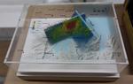
3-D Model: Port Hills Faults
Images, Canterbury Museum
One oblong perspex covered 3-D model of the fault plains that ruptured to cause the 22 February and 13 June 2011 earthquakes; top of the model also acts as a map overlay. This model provides a visual demonstration of the geological forces that caused the 22 February and 13 June 2011 earthquakes. These forces were so strong that parts of the Por...
Development of Multichannel Analysis of Surface Waves (MASW) for Character…
Research papers, University of Canterbury Library
Bulk rock strength is greatly dependent on fracture density, so that reductions in rock strength associated with faulting and fracturing should be reflected by reduced shear coupling and hence S-wave velocity. This study is carried out along the Canterbury rangefront and in Otago. Both lie within the broader plate boundary deformation zone in the South Island of New Zealand. Therefore built structures are often, , located in areas where there are undetected or poorly defined faults with associated rock strength reduction. Where structures are sited near to, or across, such faults or fault-zones, they may sustain both shaking and ground deformation damage during an earthquake. Within this zone, management of seismic hazards needs to be based on accurate identification of the potential fault damage zone including the likely width of off-plane deformation. Lateral S-wave velocity variability provides one method of imaging and locating damage zones and off-plane deformation. This research demonstrates the utility of Multi-Channel Analysis of Surface Waves (MASW) to aid land-use planning in such fault-prone settings. Fundamentally, MASW uses surface wave dispersive characteristics to model a near surface profile of S-wave velocity variability as a proxy for bulk rock strength. The technique can aid fault-zone planning not only by locating and defining the extent of fault-zones, but also by defining within-zone variability that is readily correlated with measurable rock properties applicable to both foundation design and the distribution of surface deformation. The calibration sites presented here have well defined field relationships and known fault-zone exposure close to potential MASW survey sites. They were selected to represent a range of progressively softer lithologies from intact and fractured Torlesse Group basement hard rock (Dalethorpe) through softer Tertiary cover sediments (Boby’s Creek) and Quaternary gravels. This facilitated initial calibration of fracture intensity at a high-velocity-contrast site followed by exploration of the limits of shear zone resolution at lower velocity contrasts. Site models were constructed in AutoCAD in order to demonstrate spatial correlations between S-wave velocity and fault zone features. Site geology was incorporated in the models, along with geomorphology, river profiles, scanline locations and crosshole velocity measurement locations. Spatial data were recorded using a total-station survey. The interpreted MASW survey results are presented as two dimensional snapshot cross-sections of the three dimensional calibration-site models. These show strong correlations between MASW survey velocities and site geology, geomorphology, fluvial profiles and geotechnical parameters and observations. Correlations are particularly pronounced where high velocity contrasts exist, whilst weaker correlations are demonstrated in softer lithologies. Geomorphic correlations suggest that off-plane deformation can be imaged and interpreted in the presence of suitable topographic survey data. A promising new approach to in situ and laboratory soft-rock material and mass characterisation is also presented using a Ramset nail gun. Geotechnical investigations typically involve outcrop and laboratory scale determination of rock mass and material properties such as fracture density and unconfined compressive strength (UCS). This multi-scale approach is espoused by this study, with geotechnical and S-wave velocity data presented at multiple scales, from survey scale sonic velocity measurements, through outcrop scale scanline and crosshole sonic velocity measurements to laboratory scale property determination and sonic velocity measurements. S-wave velocities invariably increased with decreasing scale. These scaling relationships and strategies for dealing with them are investigated and presented. Finally, the MASW technique is applied to a concealed fault on the Taieri Ridge in Macraes Flat, Central Otago. Here, high velocity Otago Schist is faulted against low velocity sheared Tertiary and Quaternary sediments. This site highlights the structural sensitivity of the technique by apparently constraining the location of the principal fault, which had been ambiguous after standard processing of the seismic reflection data. Processing of the Taieri Ridge dataset has further led to the proposal of a novel surface wave imaging technique termed Swept Frequency Imaging (SFI). This inchoate technique apparently images the detailed structure of the fault-zone, and is in agreement with the conventionally-determined fault location and an existing partial trench. Overall, the results are promising and are expected to be supported by further trenching in the near future.
3-D Model: Greendale and Associated Faults
Images, Canterbury Museum
One oblong perspex covered 3-D model of the fault plains associated with the 4 September 2010 Darfield earthquake; top of the model also acts as a map overlay. Geologists continue to study the 4 September 2010 earthquake and consider it is likely to have been a complex event with several faults rupturing simultaneously. This model provides one ...
Tectonic Geomorphology and Paleoseismicity of the Northern Esk Fault, Nort…
Research papers, University of Canterbury Library
Geomorphic, structural and chronological data are used to establish the late Quaternary paleoseismicity of the active dextral-oblique Northern Esk Fault in North Canterbury, New Zealand. Detailed field mapping of the preserved c. 35 km of surface traces between the Hurunui River and Ashley Head reveals variations in strike ranging from 005° to 057°. Along with kinematic data collected from fault plane striae and offset geomorphic markers along the length of the fault these variations are used to distinguish six structural subsections of the main trace, four dextral-reverse and two dextral-normal. Displacements of geomorphic markers such as minor streams and ridges are measured using differential GPS and rangefinder equipment to reveal lateral offsets ranging from 3.4 to 23.7 m and vertical offsets ranging from < 1 to 13.5 m. Characteristic single event displacements of c. 5 m and c. 2 m have been calculated for strike-slip and reverse sections respectively. The use of fault scaling relationships reveals an anomalously high displacement to surface rupture length ratio when compared to global data sets. Fault scaling relationships based on width limited ruptures and magnitude probabilities from point measurements of displacement imply earthquake magnitudes of Mw 7.0 to 7.5. Optically Stimulated Luminescence (OSL) ages from displaced Holocene alluvial terraces at the northern extent of the active trace along with OSL and radiocarbon samples of the central sections constrain the timing of the last two surface rupturing events (11.15 ±1.65 and 3.5 ± 2.8 ka) and suggest a recurrence interval of c. 5612 ± 445 years and late Quaternary reverse and dextral slip rates of c. 0.31 mm/yr and 0.82 mm/yr respectively. The results of this study show that the Northern Esk Fault accommodates an important component of the c. 0.7 – 2 mm/yr of unresolved strain across the plate boundary within the North Canterbury region and affirm the Esk Fault as a source of potentially damaging ground shaking in the Canterbury region.
Preliminary geometry and kinematics of multiple surface ruptures during th…
Research papers, University of Canterbury Library
The Mw 7.8 Kaikōura earthquake ruptured ~200 km at the ground surface across the New Zealand plate boundary zone in the northern South Island. This study was conducted in an area of ~600 km2 in the epicentral region where the faults comprise two main non-coplanar sets that strike E-NE and NNE-NW with mainly steep dips (60о-80°). Analysis of the surface rupture using field and LiDAR data provides new information on the dimensions, geometries and kinematics of these faults which was not previously available from pre-earthquake active faults or bedrock structure. The more northerly striking fault set are sub-parallel to basement bedding and accommodated predominantly left-lateral reverse slip with net slips of ~1 and ~5 m for the Stone Jug and Leader faults, respectively. The E-NE striking Conway-Charwell and The Humps faults accrued right-lateral to oblique reverse with net slips of ~2 and ~3 m, respectively. The faults form a hard-linked system dominated by kinematics consistent with the ~260° trend of the relative plate motion vector and the transpressional structures recorded across the plate boundary in the NE South Island. Interaction and intersection of the main fault sets facilitated propagation of the earthquake and transfer of slip northwards across the plate boundary zone.
Strike-slip ground-surface rupture (Greendale Fault) associated with the 4…
Research papers, University of Canterbury Library
This paper provides a photographic tour of the ground-surface rupture features of the Greendale Fault, formed during the 4th September 2010 Darfield Earthquake. The fault, previously unknown, produced at least 29.5 km of strike-slip surface deformation of right-lateral (dextral) sense. Deformation, spread over a zone between 30 and 300 m wide, consisted mostly of horizontal flexure with subsidiary discrete shears, the latter only prominent where overall displacement across the zone exceeded about 1.5 m. A remarkable feature of this event was its location in an intensively farmed landscape, where a multitude of straight markers, such as fences, roads and ditches, allowed precise measurements of offsets, and permitted well-defined limits to be placed on the length and widths of the surface rupture deformation.
No Fault Here???" Rural impacts from the 4 September Canterbury earthquake
Articles, UC QuakeStudies
PDF slides from a presentation given by Dr. Thomas Wilson from the UC Geology department on 27 October 2010.
Greendale Land Survey Photograph 16
Images, UC QuakeStudies
A photograph of University of Canterbury Geology staff and students using ground penetrating radar (GPR) to survey land on the Greendale fault line.
Greendale Land Survey Photograph 11
Images, UC QuakeStudies
A photograph of University of Canterbury Geology student Matt Cockcroft using ground penetrating radar (GPR) to survey land on the Greendale fault line.
Greendale Land Survey Photograph 13
Images, UC QuakeStudies
A photograph of University of Canterbury Geology staff and students using ground penetrating radar (GPR) to survey land on the Greendale fault line.
Greendale Land Survey Photograph 04
Images, UC QuakeStudies
A photograph of University of Canterbury Geology student Matt Cockcroft using ground penetrating radar (GPR) to survey land on the Greendale fault line.
Structure and tectonic geomorphology of the Lowry Peaks Range-Waikari Vall…
Research papers, University of Canterbury Library
Structures of the Lowry Peaks Range - Waikari Valley district are complex. The majority comprise three members of a predominantly WSW -ENE striking major northwards-directed, leading edge imbricate thrust system, with associated angular, asymmetric fault-propagation folds. This system forms anomalously within a large NESW trending belt of structures characterising the entire east coast of north Canterbury, both onshore and offshore and terminates westwards against N-S striking, east facing fold-fault zone. The objectives of this study address the origin, geometry and kinematics of the interaction between these diversely trending systems. Stratigraphy and small-scale structures denote three periods of deformation, namely: i) Middle Cretaceous deformation of the basement rocks, ii) weak Middle Oligocene deformation associated with the inception of the plate boundary through the South Island, and iii) major Pliocene - Recent deformation that formed the majority of the above-mentioned structures. Stress tensor analyses within competent basement and limestone cover rocks suggest two sets of sub-horizontal compression, NE-SW and NW-SE, the former likely to relate to a localised earlier period of deformation, now overprinted by the latter. NW-SE oriented sub-horizontal compression correlates well with results from other parts of north Canterbury. The result of NW-SE compression on the W-E to WSW-ENE striking structures is a large component of oblique motion, which is manifest in four ways: i) movement on two, differently oriented splays rather than a single fault strand, ii) the development of a sinuous trace for a number of the major folds, whereby the ends are oriented normal to the compression direction, the centres parallel to the strike of the faults, iii) the development of a number of cross-folds, striking NNE-SSW and iv) the apparently recent development of a strike-slip component on at least one of the major thrust faults. The origin of the W-E, or WSW-ENE striking structures may be reactivation of Late Cretaceous faults, stratigraphic evidence for the existence of a "structural high" (the Hurunui High) over the majority of the area in the Late Cretaceous to Early Eocene times suggests the formation of a W-E trending horst structure, with a corresponding asymmetric graben to the south. The junction of WSW-ENE trending structures with N-S trending structures to the west centres on an alluvial-filled depression, Waikari Flat, into which the structures of the WSW-ENE trending imbricate thrust system plunge, locally curling to the SW at their ends to link with N-S trending structures to the south. Roof thrusting on two orientations, W-E and N-S, towards to SE is currently occurring above these structures. Currently the area is not highly seismically active, although a magnitude ~6.4 Ms earthquake in historic times has been recorded. The effects of tectonics on the drainage of the area does suggest that the majority of the systems, are still potentially active, albeit moving at a comparatively slow rate. The majority of the recent motion appears to be concentrated on the roof-thrusting occurring in Waikari Flat, and uplift along the Lowry Peaks Fault System. Increasing amounts of secondary movement on back-thrusts and cross fractures is also implied for western ends of the major imbricate thrust system. In contrast, the southern-most fault system appears to be largely sustaining dextral strike-slip motion, with some local folding in central portions.
The Structural and Geomorphic Development of Active Collisional Orogens, f…
Research papers, University of Canterbury Library
The structure and geomorphology of active orogens evolves on time scales ranging from a single earthquake to millions of years of tectonic deformation. Analysis of crustal deformation using new and established remote sensing techniques, and integration of these data with field mapping, geochronology and the sedimentary record, create new opportunities to understand orogenic evolution over these timescales. Timor Leste (East Timor) lies on the northern collisional boundary between continental crust from the Australian Plate and the Banda volcanic arc. GPS studies have indicated that the island of Timor is actively shortening. Field mapping and fault kinematic analysis of an emergent Pliocene marine sequence identifies gentle folding, overprinted by a predominance of NW-SE oriented dextral-normal faults and NE-SW oriented sinistral-normal faults that collectively bound large (5-20km2) bedrock massifs throughout the island. These fault systems intersect at non-Andersonian conjugate angles of approximately 120° and accommodate an estimated 20 km of orogen-parallel extension. Folding of Pliocene rocks in Timor may represent an early episode of contraction but the overall pattern of deformation is one of lateral crustal extrusion sub-parallel to the Banda Arc. Stratigraphic relationships suggest that extrusion began prior to 5.5 Ma, during and after initial uplift of the orogen. Sedimentological, geochemical and Nd isotope data indicate that the island of Timor was emergent and shedding terrigenous sediment into carbonate basins prior to 4.5 Ma. Synorogenic tectonic and sedimentary phases initiated almost synchronously across much of Timor Leste and <2 Myr before similar events in West Timor. An increase in plate coupling along this obliquely converging boundary, due to subduction of an outlying continental plateau at the Banda Trench, is proposed as a mechanism for uplift that accounts for orogen-parallel extension and early uplift of Timor Leste. Rapid bathymetric changes around Timor are likely to have played an important role in evolution of the Indonesian Seaway. The 2010 Mw 7.1 Darfield (Canterbury) earthquake in New Zealand was complex, involving multiple faults with strike-slip, reverse and normal displacements. Multi-temporal cadastral surveying and airborne light detection and ranging (LiDAR) surveys allowed surface deformation at the junction of three faults to be analyzed in this study in unprecedented detail. A nested, localized restraining stepover with contractional bulging was identified in an area with the overall fault structure of a releasing bend, highlighting the surface complexities that may develop in fault interaction zones during a single earthquake sequence. The earthquake also caused river avulsion and flooding in this area. Geomorphic investigations of these rivers prior to the earthquake identify plausible precursory patterns, including channel migration and narrowing. Comparison of the pre and post-earthquake geomorphology of the fault rupture also suggests that a subtle scarp or groove was present along much of the trace prior to the Darfield earthquake. Hydrogeology and well logs support a hypothesis of extended slip history and suggests that that the Selwyn River fan may be infilling a graben that has accumulated late Quaternary vertical slip of <30 m. Investigating fault behavior, geomorphic and sedimentary responses over a multitude of time-scales and at different study sites provides insights into fault interactions and orogenesis during single earthquakes and over millions of years of plate boundary deformation.
Greendale Land Survey Photograph 12
Images, UC QuakeStudies
A photograph of University of Canterbury Geology students Zach Whitman and Dewiyani Bealing using ground penetrating radar equipment to survey land on the Greendale fault line.
Greendale Land Survey Photograph 05
Images, UC QuakeStudies
A photograph of University of Canterbury Geology staff and students using a dynamic cone penetrometer to measure soil strength of a paddock on the Greendale fault line.