Search
Images for Earthquake damage; more images...
Earthquake Damage.
Images, eqnz.chch.2010
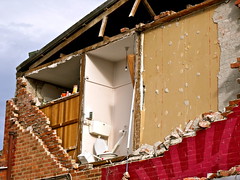
Damage from the Christchurch earthquake that hit on 4/9/10 @ 4:35am. Measured 7.1 on the richter scale.
Earthquake Damage.
Images, eqnz.chch.2010
Damage from the Christchurch earthquake that hit on 4/9/10 @ 4:35am. Measured 7.1 on the richter scale.
earthquake damage
Images, eqnz.chch.2010
Damage from the Christchurch 7.1 earthquake on 4th Sept 2010
Earthquake Damage.
Images, eqnz.chch.2010
Damage from the Christchurch earthquake that hit on 4/9/10 @ 4:35am. Measured 7.1 on the richter scale.
earthquake damage
Images, eqnz.chch.2010
Damage from the Christchurch 7.1 earthquake on 4th Sept 2010
earthquake damage
Images, eqnz.chch.2010
Damage from the Christchurch 7.1 earthquake on 4th Sept 2010
earthquake damage
Images, eqnz.chch.2010
Damage from the Christchurch 7.1 earthquake on 4th Sept 2010 Church of St. John the Baptist, Latimer Square, Christchurch, New Zealand
earthquake damage
Images, eqnz.chch.2010
Damage from the Christchurch 7.1 earthquake on 4th Sept 2010
Earthquake Damage
Images, eqnz.chch.2010
2010-4232 Christchurch earthquake 7.1M 4 Sep 10
earthquake damage
Images, eqnz.chch.2010
Damage from the Christchurch 7.1 earthquake on 4th Sept 2010
Damaged
Images, eqnz.chch.2010
Awaiting restoration, the Cathedral was damaged in a series of major earthquakes. 52 in 2018: 30. Ruin or Archaelogical site
Lyttelton earthquake damage
Images, eqnz.chch.2010
None
Kaiapoi, earthquake damage
Images, eqnz.chch.2010
Damage from the Christchurch 7.1 earthquake on 4th Sept 2010
probable earthquake damage 1b
Images, eqnz.chch.2010
deduced from the fact the breaks appeared new and others damaged around it.
probable earthquake damage 1a
Images, eqnz.chch.2010
deduced from the fact the breaks appeared new and others damaged around it.
Christchurch Earthquake
Images, eqnz.chch.2010
Harbourlight Lyttelton - condoned off due to damage
Lyttelton Cemetery earthquake damage
Images, eqnz.chch.2010
None
An Earthquake Damaged Cliff Top Home
Images, UC QuakeStudies
Damage to a wooden house at the top of a cliff.
Damage observations following the MW 7.8 2016 Kaikoura earthquake
Research papers, The University of Auckland Library
On 14 November 2016 a magnitude Mw 7.8 earthquake struck the upper South Island of New Zealand with effects also being observed in the capital city, Wellington. The affected area has low population density but is the largest wine production region in New Zealand and also hosts the main national highway and railway routes connecting the country’s three largest cities of Auckland, Wellington and Christchurch, with Marlborough Port in Picton providing connection between the South and North Islands. These transport facilities sustained substantial earthquake related damage, causing major disruptions. Thousands of landslides and multiple new faults were counted in the area. The winery facilities and a large number of commercial buildings and building components (including brick masonry veneers, historic masonry construction, and chimneys), sustained damage due to the strong vertical and horizontal acceleration. Presented herein are field observations undertaken the day immediately after the earthquake, with the aim to document earthquake damage and assess access to the affected area.
Ruth Gardner's Blog 26/02/2011: Shaken City
Articles, UC QuakeStudies
An entry from Ruth Gardner's blog for 26 February 2011 entitled, "Shaken City".
Canterbury's Earthquakes
Audio, Radio New Zealand
GNS seismologists explain why the Darfield and Christchurch earthquakes were so damaging and 'punchy'
Lyttelton Review 19 March 2012
Articles, UC QuakeStudies
The "Lyttelton Review" newsletter for 19 March 2012, produced by the Lyttelton Harbour Information Centre.
Ruth Gardner's Blog 04/05/2011: Earthquake Alphabet
Articles, UC QuakeStudies
An entry from Ruth Gardner's blog for 4 May 2011 entitled, "Earthquake Alphabet".
Transect Survey as a Post-Disaster Global Rapid Damage Assessment Tool
Research papers, The University of Auckland Library
Following a damaging earthquake, the immediate emergency response is focused on individual collapsed buildings or other "hotspots" rather than the overall state of damage. This lack of attention to the global damage condition of the affected region can lead to the reporting of misinformation and generate confusion, causing difficulties when attempting to determine the level of postdisaster resources required. A pre-planned building damage survey based on the transect method is recommended as a simple tool to generate an estimate of the overall level of building damage in a city or region. A methodology for such a transect survey is suggested, and an example of a similar survey conducted in Christchurch, New Zealand, following the 22 February 2011 earthquake is presented. The transect was found to give suitably accurate estimates of building damage at a time when information was keenly sought by government authorities and the general public. VoR - Version of Record
20130106_1240_1D3-60 Medway Street footbridge-2
Images, eqnz.chch.2010
Earthquake damage. As a result of the September 2010 earthquake, with further damage from the February 2011 event.
20130106_1239_1D3-75 Medway Street footbridge-3
Images, eqnz.chch.2010
Earthquake damage. As a result of the September 2010 earthquake, with further damage from the February 2011 event.
20130106_1238_1D3-60 Medway Street footbridge-1
Images, eqnz.chch.2010
Earthquake damage. As a result of the September 2010 earthquake, with further damage from the February 2011 event.
Transcript of Bernadette Cooney's earthquake story
Articles, UC QuakeStudies
A pdf transcript of Bernadette Cooney's earthquake story, captured by the UC QuakeBox project.
Lyttelton Harbour Review 15 July 2013
Articles, UC QuakeStudies
The "Lyttelton Harbour Review" newsletter for 15 July 2013, produced by the Lyttelton Harbour Information Centre.
Fairfax Video, October 2010 (12)
Videos, UC QuakeStudies
Part seven of a video series about the first stage of the Tonkin & Taylor Geotechnical Land Damage Assessment and Reinstatement Report. The report was prepared for the Earthquake Commission after the 4 September 2010 earthquake.


