Search
found 33 results
Images for 22; more images...


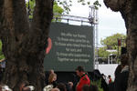
Digital Photograph: Brass Band at the Canterbury Earthquake Memorial Servi…
Images, Canterbury Museum
One landscape colour digital photograph taken 22 February 2017 showing brass band members at the Canterbury Earthquake Memorial Service. Behind the band is a digital screen showing words of thanks from survivors.
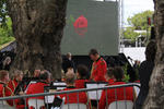
Digital Photograph: Guests Arriving at the Canterbury Earthquake Memorial …
Images, Canterbury Museum
One landscape colour digital photograph taken 22 February 2017 showing guests being seated prior to the Canterbury Earthquake Memorial Service.
Digital Photograph: First Responders at the Canterbury Earthquake Memorial…
Images, Canterbury Museum
One landscape colour digital photograph taken 22 February 2017 showing first responders at the Canterbury Earthquake Memorial Service.
Digital Photograph: Brass Band at the Canterbury Earthquake Memorial Servi…
Images, Canterbury Museum
One landscape colour digital photograph taken 22 February 2017 showing brass band members at the Canterbury Earthquake Memorial Service. Behind the band is a digital screen showing an image of flowers floating in the Avon River.
Digital Photograph: Members of the Media at the Canterbury Earthquake Memo…
Images, Canterbury Museum
One landscape colour digital photograph taken 22 February 2017 showing cameramen and journalists at the Canterbury Earthquake Memorial Service.
Digital Photograph: Media Viewing Area at the Canterbury Earthquake Memori…
Images, Canterbury Museum
One landscape colour digital photograph taken 22 February 2017 showing the appointed media viewing area at the Canterbury Earthquake Memorial Service.
Digital Photograph: First Responders and Public Viewing Areas at the Cante…
Images, Canterbury Museum
One landscape colour digital photograph taken 22 February 2017 showing the appointed first responders and public viewing areas at the Canterbury Earthquake Memorial Service.
Digital Photograph: First Responders Laying Wreaths at the Canterbury Eart…
Images, Canterbury Museum
One landscape colour digital photograph taken 22 February 2017 showing first responders laying wreaths at the Canterbury Earthquake Memorial Service.
Digital Photograph: Commemoration Board at the Canterbury Earthquake Memor…
Images, Canterbury Museum
One landscape colour digital photograph taken 22 February 2017 showing a gentleman reading messages on a commemoration board at the Canterbury Earthquake Memorial Service.
Digital Photograph: Flowers Floating in the Avon River
Images, Canterbury Museum
One landscape colour digital photograph taken 22 February 2017 showing flowers floating in the Avon River as part of the Canterbury Earthquake Memorial Service.
Digital Photograph: Sunflower Atop a Road Works Cone
Images, Canterbury Museum
One landscape colour digital photograph taken 22 February 2017 showing a sunflower sitting atop a road works cone as part of the Canterbury Earthquake Memorial Service.
Digital Photograph: Earthquake Memorial Trellis
Images, Canterbury Museum
One landscape colour digital photograph taken 22 February 2017 showing an earthquake memorial trellis at the site of the former Canterbury Television building.
Digital Photograph: Commemorative Note to Andrew Bishop
Images, Canterbury Museum
One landscape colour digital photograph taken 22 February 2017 showing a commemorative note to, and photograph of, Andrew Bishop attached to an earthquake memorial trellis at the site of the former Canterbury Television building.
Digital Photograph: Flowers on an Earthquake Memorial Trellis
Images, Canterbury Museum
One landscape colour digital photograph taken 22 February 2017 showing a bouquet of flowers and a note attached to an earthquake memorial trellis at the site of the former Canterbury Television building.
Digital Photograph: Earthquake Memorial Trellis
Images, Canterbury Museum
One landscape colour digital photograph taken 22 February 2017 showing an earthquake memorial trellis at the site of the former Canterbury Television building.
Digital Photograph: Karen Bishop at an Earthquake Memorial Trellis
Images, Canterbury Museum
One landscape colour digital photograph taken 22 February 2017 showing Karen Bishop attaching a windmill to an earthquake memorial trellis in memory of her son Andrew Bishop at the site of the former Canterbury Television building.
Digital Photograph: Windmill Attached to an Earthquake Memorial Trellis
Images, Canterbury Museum
One landscape colour digital photograph taken 22 February 2017 showing a windmill attached to an earthquake memorial trellis by Karen Bishop in memory of her son Andrew Bishop at the site of the former Canterbury Television building.
Digital Photograph: Flowers at the Site of the Former Canterbury Televisio…
Images, Canterbury Museum
One landscape colour digital photograph taken 22 February 2017 showing a bouquet of flowers left at the site of the former Canterbury Television building by the Toyama Language School in memory of earthquake victims.
Digital Photograph: Flowers at the Site of the Former Canterbury Televisio…
Images, Canterbury Museum
One landscape colour digital photograph taken 22 February 2017 showing bouquets of flowers and gifts left at the site of the former Canterbury Television building in memory of earthquake victims.
Digital Photograph: Flowers at the Site of the Former Canterbury Televisio…
Images, Canterbury Museum
One landscape colour digital photograph taken 22 February 2017 showing a bouquet of flowers left at the site of the former Canterbury Television building by St John New Zealand in memory of earthquake victims and in appreciation of first responders.
Remembrance (129/365)
Images, eqnz.chch.2010
20170509_6305_7D2-62 Remembrance (129/365) Today was the first time I have been to the earthquake memorial since it was completed and opened on 22nd February 2017, six years after the devastating quake that killed the 185 that are named on this wall. I knew two of the people on the list.
From darkness comes light: music as a reflection of the lived experience o…
Research papers, University of Canterbury Library
Context of the project: On 4 September 2010, 22 February 2011, 13 June 2011 and 23 December 2011 Christchurch suffered major earthquakes and aftershocks (well over 10,000) that have left the central city in ruins and many of the eastern suburbs barely habitable even now. The earthquakes on 22 February caused catastrophic loss of life with 185 people killed. The toll this has taken on the residents of Christchurch has been considerable, not least of all for the significant psychological impact and disruption it has had on the children. As the process of rebuilding the city commenced, it became clear that the arts would play a key role in maintaining our quality of life during difficult times. For me, this started with the children and the most expressive of all the art forms – music.
Previsione degli effetti di liquefazione su scala urbana
Research papers, University of Canterbury Library
Nel presente articolo si illustra una procedura per il processamento automatizzato di prove CPT, il calcolo di vari indici di liquefazione e la rappresentazione dei dati su mappa. La procedura è applicata al caso studio del terremoto di Christchurch, Nuova Zelanda, del 22 febbraio 2011 (magnitudo momento, Mw = 6.2). Dall’analisi spaziale dei risultati emerge una buona correlazione tra le mappe ottenute per l’indicatore degli effetti al suolo e i danni osservati (su terreni e strutture). Tuttavia, per confermare la validità di tale procedura, sarà necessario esaminare ulteriori casi studio nel mondo.
A comparison of CPT-Vs correlations using a liquefaction case history data…
Research papers, University of Canterbury Library
This study uses 44 high quality liquefaction case histories taken from 22 locations affected by the 2010-2011 Canterbury earthquake sequence to evaluate four commonly used CPT-VS correlations (i.e., Robertson, 2009; Hegazy and Mayne, 2006; Andrus et al., 2007; McGann et al., 2015b). Co-located CPT soundings and VS profiles, developed from surface wave testing, were obtained at 22 locations and case histories were developed for the Mw 7.1, 4 September 2010 Darfield and Mw 6.2, 22 February 2011 Christchurch earthquakes. The CPT soundings are used to generate VS profiles using each of four CPT-VS correlations. These correlated VS profiles are used to estimate the factor of safety against liquefaction using the Kayen et al. (2013) VS-based simplified liquefaction evaluation procedure. An error index is used to quantify the predictive capabilities of these correlations in relation to the observations of liquefaction (or the lack thereof). Additionally, the error indices from the CPT-correlated VS profiles are compared to those obtained using: (1) the Kayen et al. (2013) procedure with surface wave-derived VS profiles, and (2) the Idriss and Boulanger (2008) CPT-based liquefaction evaluation procedure. Based on the error indices, the evaluation procedures based on direct measurements of either CPT or VS provided more accurate liquefaction triggering estimates than those obtained from any of the CPT-VS correlations. However, the performance of the CPT-VS correlations varied, with the Robertson (2009) and Hegazy and Mayne (2006) correlations performing relatively poorly for the Christchurch soils and the Andrus et al. (2007) and McGann et al. (2015b) correlations performing better. The McGann et al. (2015b) correlation had the lowest error indices of the CPT-VS correlations tested, however, none of the CPT-VS correlations provided accurate enough VS predictions to be used for the evaluation of liquefaction triggering using the VS-based liquefaction evaluation procedures.
Fragility functions for buried pipelines in liquefiable soils based on New…
Research papers, University of Canterbury Library
This poster aims to present fragility functions for pipelines buried in liquefaction-prone soils. Existing fragility models used to quantify losses can be based on old data or use complex metrics. Addressing these issues, the proposed functions are based on the Christchurch network and soil and utilizes the Canterbury earthquake sequence (CES) data, partially represented in Figure 1. Figure 1 (a) presents the pipe failure dataset, which describes the date, location and pipe on which failures occurred. Figure 1 (b) shows the simulated ground motion intensity median of the 22nd February 2011 earthquake. To develop the model, the network and soil characteristics have also been utilized
Fragility functions for buried pipelines in liquefaction-prone areas based…
Research papers, University of Canterbury Library
Motivation This poster aims to present fragility functions for pipelines buried in liquefaction-prone soils. Existing fragility models used to quantify losses can be based on old data or use complex metrics. Addressing these issues, the proposed functions are based on the Christchurch network and soil and utilizes the Canterbury earthquake sequence (CES) data, partially represented in Figure 1. Figure 1 (a) presents the pipe failure dataset, which describes the date, location and pipe on which failures occurred. Figure 1 (b) shows the simulated ground motion intensity median of the 22nd February 2011 earthquake. To develop the model, the network and soil characteristics have also been utilized.
Alternative Radio : exhibiting radio and music heritage after the Christch…
Research papers, University of Canterbury Library
This article examines the representation of Christchurch, New Zealand, student radio station RDU in the exhibition Alternative Radio at the Canterbury Museum in 2016. With the intention of ‘making visible what is invisible’ about radio broadcasting, the exhibition articulated RDU as a point of interconnection between the technical elements of broadcasting, the social and musical culture of station staff and volunteers, and the broader local and national music scenes. This paper is grounded in observations of the exhibitions and associated public programmes, and interviews with the key participants in the exhibition including the museum's exhibition designer and staff from RDU, who acted as independent practitioners in collaboration with the museum. Alternative Radio also addressed the aftermath of the major earthquake of 22 February 2011, when RDU moved into a customised horse truck after losing its broadcast studio. The exhibition came about because of the cultural resonance of the post-quake story, but also emphasised the long history of the station before that event, and located this small student radio station in the broader heritage discourse of the Canterbury museum, activating the historical, cultural, and personal memories of the station's participants and audiences.
Post Seismic Capacity of Damaged and Repaired Reinforced Concrete Plastic …
Research papers, University of Canterbury Library
This paper presents preliminary results of an experimental campaign on three beam-column joint subassemblies extracted from a 22-storey reinforced concrete frame building constructed in late 1980s at the Christchurch’s Central Business District (CBD) area, damaged and demolished after the 2010-2011 Canterbury earthquakes sequence (CES). The building was designed following capacity design principles. Column sway (i.e., soft storey) mechanisms were avoided, and the beams were provided with plastic hinge relocation details at both beam-ends, aiming at developing plastic hinges away from the column faces. The specimens were tested under quasi-static cyclic displacement controlled lateral loading. One of the specimens, showing no visible residual cracks was cyclically tested in its as-is condition. The other two specimens which showed residual cracks varying between hairline and 1.0mm in width, were subjected to cyclic loading to simulate cracking patterns consistent with what can be considered moderate damage. The cracked specimens were then repaired with an epoxy injection technique and subsequently retested until reaching failure. The epoxy injection techniques demonstrated to be quite efficient in partly, although not fully, restoring the energy dissipation capacities of the damaged specimens at all beam rotation levels. The stiffness was partly restored within the elastic range and almost fully restored after the onset of nonlinear behaviour.
The Interdependence and Recovery of Critical Infrastructure Networks Follo…
Research papers, The University of Auckland Library
Critical infrastructure networks are highly relied on by society such that any disruption to service can have major social and economic implications. Furthermore, these networks are becoming increasingly dependent on each other for normal operation such that an outage or asset failure in one system can easily propagate and cascade across others resulting in widespread disruptions in terms of both magnitude and spatial reach. It is the vulnerability of these networks to disruptions and the corresponding complexities in recovery processes which provide direction to this research. This thesis comprises studies contributing to two areas (i) the modelling of national scale in-terdependent infrastructure systems undergoing major disruptions, and (ii) the tracking and quantification of infrastructure network recovery trajectories following major disruptions. Firstly, methods are presented for identifying nationally significant systemic vulnerabilities and incorporating expert knowledge into the quantification of infrastructure interdependency mod-elling and simulation. With application to the interdependent infrastructures networks across New Zealand, the magnitudes and spatial extents of disruption are investigated. Results high-light the importance in considering interdependencies when assessing disruptive risks and vul-nerabilities in disaster planning applications and prioritising investment decisions for enhancing resilience of national networks. Infrastructure dependencies are further studied in the context of recovery from major disruptions through the analysis of curves measuring network functionality over time. Continued studies into the properties of recovery curves across a database of global natural disasters produce statistical models for predicting the trajectory and expected recovery times. Finally, the use of connectivity based metrics for quantifying infrastructure system functionality during recovery are considered with a case study application to the Christchurch Earthquake (February 22, 2011) wastewater network response
Amplification of strong ground motions at Heathcote Valley during the 2010…
Research papers, University of Canterbury Library
This article presents a quantitative case study on the site amplification effect observed at Heathcote Valley, New Zealand, during the 2010-2011 Canterbury earthquake sequence for 10 events that produced notable ground acceleration amplitudes up to 1.4g and 2.2g in the horizontal and vertical directions, respectively. We performed finite element analyses of the dynamic response of the valley, accounting for the realistic basin geometry and the soil non-linear response. The site-specific simulations performed significantly better than both empirical ground motion models and physics based regional-scale ground motion simulations (which empirically accounts for the site effects), reducing the spectral acceleration prediction bias by a factor of two in short vibration periods. However, our validation exercise demonstrated that it was necessary to quantify the level of uncertainty in the estimated bedrock motion using multiple recorded events, to understand how much the simplistic model can over- or under-estimate the ground motion intensities. Inferences from the analyses suggest that the Rayleigh waves generated near the basin edge contributed significantly to the observed high frequency (f>3Hz) amplification, in addition to the amplification caused by the strong soil-rock impedance contrast at the site fundamental frequency. Models with and without considering soil non-linear response illustrate, as expected, that the linear elastic assumption severely overestimates ground motions in high frequencies for strong earthquakes, especially when the contribution of basin edge-generated Rayleigh waves becomes significant. Our analyses also demonstrate that the effect of pressure-dependent soil velocities on the high frequency ground motions is as significant as the amplification caused by the basin edge-generated Rayleigh waves.
- 1
- »