Search
found 157 results
Images for 22 February 2014; more images...


Christchurch Press 22 February 2014: Section C, Page 9
Articles, UC QuakeStudies
Page 9 of Section C of the Christchurch Press, published on Saturday 22 February 2014.
Christchurch Press 22 February 2014: Section D, Page 4
Articles, UC QuakeStudies
Page 4 of Section D of the Christchurch Press, published on Saturday 22 February 2014.
Christchurch Press 22 February 2014: Section A, Page 4
Articles, UC QuakeStudies
Page 4 of Section A of the Christchurch Press, published on Saturday 22 February 2014.
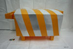
Sculpture: Sheep
Images, Canterbury Museum
One yellow plastic sheep of cuboid shape with reflective stripes around body.
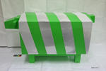
Sculpture: Sheep
Images, Canterbury Museum
One green plastic sheep of cuboid shape with reflective stripes around body.
Fairfax Video, February 2014 (1)
Videos, UC QuakeStudies
A video of a reunion between John Abraham and Josh Anderson. Abraham saved Anderson's life after he was buried under rubble from the Durham Street Methodist Church on the 22 February 2011. They are meeting for the first time in three years on the site of the demolished church.
Soft Sculpture Kakapo: Little Ra
Images, Canterbury Museum
One green and yellow soft sculpture kakapo with wire feet, stuffed body and black plastic eyes. Has an attached card naming the bird Little Ra and explaining it is part of the 'Journey - The Kakapo of Christchurch' project by artist Sayraphim Lothian.
Chch insurers among world's slowest
Audio, Radio New Zealand
Three years on from the February 22nd Christchurch earthquake hundreds of businesses are still waiting for their insurance claims to be settled.
Award: Canstruction Christchurch
Images, Canterbury Museum
One glass trophy presented to SCIRT IST to mark winning the Jurors Favourite Category in the 2014 Canstruction Christchurch competition.
Certificate: Canstruction Christchurch
Images, Canterbury Museum
One framed certificate presented to SCIRT IST to mark winning the Jurors Favourite Category in the 2014 Canstruction Christchurch competition.
Fairfax Video, March 2014 (5)
Videos, UC QuakeStudies
A video of an interview with New Zealand Fire Service Chief Executive and National Commander Paul Baxter, about the findings of the coronial inquest into the CTV building deaths. Coroner Gordon Matenga found that failures by the Fire Service and Urban Search and Rescue did not contribute to the deaths of eight students at the CTV site in the aftermath of the 22 February 2011 earthquake. Baxter talks about the importance of acknowledging the families of the deceased, and the changes and improvements that have been made by the New Zealand Fire Service since the collapse of the CTV building.
Isaac Theatre Royal - Vanessa Carswell
Audio, Radio New Zealand
It's been a long road to restore Christchurch's Isaac Theatre Royal, but tonight, it will finally open its doors again. The theatre sustained considerable damage in the earthquakes of 22nd February and 13th June 2011 and continuing shakes have made the restoration particularly difficult for architects. The project architect from Warren and Mahoney, is Vanessa Carswell.
Photographic Services Photograph 07
Images, UC QuakeStudies
A photograph of Graeme Kershaw, Technician at the University of Canterbury Department of Physics and Astronomy, scratching his head as he looks at the damaged clock drive of the Townsend Telescope. The telescope was damaged during the 22 February 2011 earthquake, when the Observatory tower at the Christchurch Arts Centre collapsed. Kershaw has been given the task of restoring the telescope.
Photographic Services Photograph 08
Images, UC QuakeStudies
A photograph of Graeme Kershaw, Technician at the University of Canterbury Department of Physics and Astronomy, looking through the lens of the Townsend Telescope. The lens is the most crucial component of the telescope. It was found unscratched and unbroken in the rubble of the Observatory tower, after 22 February 2011 earthquake. This means that the telescope can be restored.
Photographic Services Photograph 01
Images, UC QuakeStudies
A photograph of Graeme Kershaw, Technician at the University of Canterbury Department of Physics and Astronomy, sitting among the damaged parts of the Townsend Telescope. The telescope was damaged during the 22 February 2011 earthquake, when the Observatory tower at the Christchurch Arts Centre collapsed. Kershaw has been given the task of restoring the telescope. In this photograph he is holding the telescope's clock drive.
Photographic Services Photograph 02
Images, UC QuakeStudies
A photograph of Graeme Kershaw, Technician at the University of Canterbury Department of Physics and Astronomy, sitting among the damaged parts of the Townsend Telescope. The telescope was damaged during the 22 February 2011 earthquake, when the Observatory tower at the Christchurch Arts Centre collapsed. Kershaw has been given the task of restoring the telescope. In this photograph he is holding the telescope's clock drive.
Photographic Services Photograph 03
Images, UC QuakeStudies
A photograph of Graeme Kershaw, Technician at the University of Canterbury Department of Physics and Astronomy, sitting among the damaged parts of the Townsend Telescope. The telescope was damaged during the 22 February 2011 earthquake, when the Observatory tower at the Christchurch Arts Centre collapsed. Kershaw has been given the task of restoring the telescope. In this photograph he is holding the telescope's clock drive.
Photographic Services Photograph 04
Images, UC QuakeStudies
A photograph of Graeme Kershaw, Technician at the University of Canterbury Department of Physics and Astronomy, sitting among the damaged parts of the Townsend Telescope. The telescope was damaged during the 22 February 2011 earthquake, when the Observatory tower at the Christchurch Arts Centre collapsed. Kershaw has been given the task of restoring the telescope. In this photograph he is holding the telescope's clock drive.
20140112_7511_1D3-195 External Stairway
Images, eqnz.chch.2010
External stairs on the Forsyth Barr building in Christchurch. Portions of the internal stairwell collapsed during the earthquake of February 22nd 2011, necessitating use of various means of getting people out of the building. Was the fourth highest building in the city pre earthquakes, but it's future is uncertain. Was for sale "as is, where ...
20141005_2502_1D3-40 CTV site
Images, eqnz.chch.2010
The sign reads: The CTV Building was headquarters of Canterbury Television (CTV) and also housed King’s Education language School, a medical clinic, Hair Consultants, Relationship Services and a nursing school. On February 22nd 2011 the building collapsed as a result of a major earthquake. Sadly, 115 people who were in the building lost their l...
Photographic Services Photograph 09
Images, UC QuakeStudies
A photograph of Graeme Kershaw, Technician at the University of Canterbury Department of Physics and Astronomy, looking through the lens of the Townsend Telescope. The lens is the most crucial component of the telescope. It was found unscratched and unbroken in the rubble of the Observatory tower, after 22 February 2011 earthquake. This means that the telescope can be restored. Other parts of the earthquake-damaged telescope are in the background of the photograph.
Photographic Services Photograph 10
Images, UC QuakeStudies
A photograph of Graeme Kershaw, Technician at the University of Canterbury Department of Physics and Astronomy, looking through the lens of the Townsend Telescope. The lens is the most crucial component of the telescope. It was found unscratched and unbroken in the rubble of the Observatory tower, after 22 February 2011 earthquake. This means that the telescope can be restored. Other parts of the earthquake-damaged telescope are in the background of the photograph.
Integrated Data and Recovery: The UC CEISMIC Federated Archive
Research papers, University of Canterbury Library
The UC CEISMIC Canterbury Earthquakes Digital Archive was built following the devastating earthquakes that hit the Canterbury region in the South Island of New Zealand from 2010 – 2012. 185 people were killed in the 6.3 magnitude earthquake of February 22nd 2011, thousands of homes and businesses were destroyed, and the local community endured over 10,000 aftershocks. The program aims to document and protect the social, cultural, and intellectual legacy of the Canterbury community for the purposes of memorialization and enabling research. The nationally federated archive currently stores 75,000 items, ranging from audio and video interviews to images and official reports. Tens of thousands more items await ingestion. Significant lessons have been learned about data integration in post-disaster contexts, including but not limited to technical architecture, governance, ingestion process, and human ethics. The archive represents a model for future resilience-oriented data integration and preservation products.
The landscape record of blind fault earthquakes
Research papers, University of Canterbury Library
Active faults capable of generating highly damaging earthquakes may not cause surface rupture (i.e., blind faults) or cause surface ruptures that evade detection due to subsequent burial or erosion by surface processes. Fault populations and earthquake frequency-‐magnitude distributions adhere to power laws, implying that faults too small to cause surface rupture but large enough to cause localized strong ground shaking densely populate continental crust. The rupture of blind, previously undetected faults beneath Christchurch, New Zealand in a suite of earthquakes in 2010 and 2011, including the fatal 22 February 2011 moment magnitude (Mw) 6.2 Christchurch earthquake and other large aftershocks, caused a variety of environmental impacts, including major rockfall, severe liquefaction, and differential surface uplift and subsidence. All of these effects occurred where geologic evidence for penultimate effects of the same nature existed. To what extent could the geologic record have been used to infer the presence of proximal, blind and / or unidentified faults near Christchurch? In this instance, we argue that phenomena induced by high intensity shaking, such as rock fragmentation and rockfall, revealed the presence of proximal active faults in the Christchurch area prior to the recent earthquake sequence. Development of robust earthquake shaking proxy datasets should become a higher scientific priority, particularly in populated regions.
Māori and the Christchurch earthquakes: The interplay between Indigenous e…
Research papers, Lincoln University
The disastrous earthquakes that struck Christchurch in 2010 and 2011 seriously impacted on the individual and collective lives of Māori residents. This paper continues earlier, predominantly qualitative research on the immediate effects on Māori by presenting an analysis of a survey carried out 18 months after the most destructive event, on 22 February 2011. Using a set-theoretic approach, pathways to Māori resilience are identified, emphasising the combination of whānau connectivity and high incomes in those who have maintained or increased their wellbeing post-disaster. However, the results show that if resilience is used to describe a “bounce back” in wellbeing, Māori are primarily enduring the post-disaster environment. This endurance phase is a precursor to any resilience and will be of much longer duration than first thought. With continued uncertainty in the city and wider New Zealand economy, this endurance may not necessarily lead to a more secure environment for Māori in the city.
Photographic Services Photograph 06
Images, UC QuakeStudies
A photograph of Graeme Kershaw, Technician at the University of Canterbury Department of Physics and Astronomy, sitting among the damaged parts of the Townsend Telescope. The telescope was damaged during the 22 February 2011 earthquake, when the Observatory tower at the Christchurch Arts Centre collapsed. Kershaw has been given the task of restoring the telescope. In this photograph he is holding the telescope's clock drive. In the foreground there is a plaque reading, "The equatorial telescope and accessories in this observatory were presented to Canterbury College by James Townsend Esq. 1891. A large contribution towards the erection of the tower was made by the Canterbury Astronomical Society".
Photographic Services Photograph 05
Images, UC QuakeStudies
A photograph of Graeme Kershaw, Technician at the University of Canterbury Department of Physics and Astronomy, sitting among the damaged parts of the Townsend Telescope. The telescope was damaged during the 22 February 2011 earthquake, when the Observatory tower at the Christchurch Arts Centre collapsed. Kershaw has been given the task of restoring the telescope. In this photograph he is holding the telescope's clock drive. In the foreground there is a plaque reading, "The equatorial telescope and accessories in this observatory were presented to Canterbury College by James Townsend Esq. 1891. A large contribution towards the erection of the tower was made by the Canterbury Astronomical Society".
Hydrogeological Investigation of Earthquake Related Springs in the Hillsbo…
Research papers, University of Canterbury Library
This thesis is concerned with springs that appeared in the Hillsborough, Christchurch during the 2010-2011 Canterbury Earthquake Sequence, and which have continued to discharge groundwater to the surface to the present time. Investigations have evolved, measurements of discharge at selected sites, limited chemical data on anions and isotope analysis. The springs are associated with earthquake generated fissures (extensional) and compression zones, mostly in loess-colluvium soils of the valley floor and lower slopes. Extensive peat swamps are present in the Hillsborough valley, with a groundwater table at ~1m below ground. The first appearance of the ‘new’ springs took place following the Mw 7.1 Darfield Earthquake on 4 September 2010, and discharges increased both in volume and extent of the Christchurch Mw 6.3 Earthquake of 22 February 2011. Five monitored sites show flow rates in the range of 4.2-14.4L/min, which have remained effectively constant for the duration of the study (2014-2015). Water chemistry analysis shows that the groundwater discharges are sourced primarily from volcanic bedrocks which underlies the valley at depths ≤50m below ground level. Isotope values confirm similarities with bedrock-sourced groundwater, and the short term (hours-days) influence of extreme rainfall events. Cyclone Lusi (2013-2014) affects were monitored and showed recovery of the bedrock derived water signature within 72 hours. Close to the mouth of the valley sediments interfinger with Waimakiriri River derived alluvium bearing a distinct and different isotope signature. Some mixing is evident at certain locations, but it is not clear if there is any influence from the Huntsbury reservoir which failed in the Port Hills Earthquake (22 February 2011) and stored groundwater from the Christchurch artesian aquifer system (Riccarton Gravel).
“We’re looking out through a window to a field of weeds and sand and stone…
Research papers, University of Canterbury Library
This article explores the scope of small-scale radio to create an auditory geography of place. It focuses on the short-term art radio project The Stadium Broadcast, which was staged in November 2014 in an earthquake-damaged sports stadium in Christchurch, New Zealand. Thousands of buildings and homes in Christchurch have been demolished since the February 22, 2011, earthquake, and by the time of the broadcast the stadium at Lancaster Park had been unused for three years and nine months, and its future was uncertain. The Stadium Broadcast constructed a radio memorial to the Park’s 130-year history through archival recordings, the memories of local people, observation of its current state, and a performed site-specificity. The Stadium Broadcast reflected on the spatiality of radio sounds and transmissions, memory, postdisaster transitionality, and the impermanence of place.
Post-disaster geotechnical response for hilly terrain: a case study from t…
Research papers, University of Canterbury Library
Case study analysis of the 2010-2011 Canterbury Earthquake Sequence (CES), which particularly impacted Christchurch City, New Zealand, has highlighted the value of practical, standardised and coordinated post-earthquake geotechnical response guidelines for earthquake-induced landslides in urban areas. The 22nd February 2011 earthquake, the second largest magnitude event in the CES, initiated a series of rockfall, cliff collapse and loess failures around the Port Hills which severely impacted the south-eastern part of Christchurch. The extensive slope failure induced by the 22nd February 200 earthquake was unprecedented; and ground motions experienced significantly exceeded the probabilistic seismic hazard model for Canterbury. Earthquake-induced landslides initiated by the 22nd February 2011 earthquake posed risk to life safety, and caused widespread damage to dwellings and critical infrastructure. In the immediate aftermath of the 22nd February 2011 earthquake, the geotechnical community responded by deploying into the Port Hills to conduct assessment of slope failure hazards and life safety risk. Coordination within the voluntary geotechnical response group evolved rapidly within the first week post-earthquake. The lack of pre-event planning to guide coordinated geotechnical response hindered the execution of timely and transparent management of life safety risk from coseismic landslides in the initial week after the earthquake. Semi-structured interviews were conducted with municipal, management and operational organisations involved in the geotechnical response during the CES. Analysis of interview dialogue highlighted the temporal evolution of priorities and tasks during emergency response to coseismic slope failure, which was further developed into a phased conceptual model to inform future geotechnical response. Review of geotechnical responses to selected historical earthquakes (Northridge, 1994; Chi-Chi, 1999; Wenchuan, 2008) has enabled comparison between international practice and local response strategies, and has emphasised the value of pre-earthquake preparation, indicating the importance of integration of geotechnical response within national emergency management plans. Furthermore, analysis of the CES and international earthquakes has informed pragmatic recommendations for future response to coseismic slope failure. Recommendations for future response to earthquake-induced landslides presented in this thesis include: the integration of post-earthquake geotechnical response with national Civil Defence and Emergency Management; pre-earthquake development of an adaptive management structure and standard slope assessment format for geotechnical response; and emergency management training for geotechnical professionals. Post-earthquake response recommendations include the development of geographic sectors within the area impacted by coseismic slope failure, and the development of a GIS database for analysis and management of data collected during ground reconnaissance. Recommendations provided in this thesis aim to inform development of national guidelines for geotechnical response to earthquake-induced landslides in New Zealand, and prompt debate concerning international best practice.