Search
found 88 results
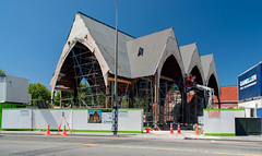
Images for up high; more images...
Photograph of Kloud 2012:10:20 14:15:33
Images, UC QuakeStudies
A photograph of architecture students wearing hard hats and high-visibility vests setting up the large-scale fabric installation titled Kloud, which is part of LUXCITY.
Photo by Jennifer Middendorf 050
Images, UC QuakeStudies
Looking down High Street from Colombo Street. A public walkway down Colombo Street to a small viewing area in the Square was opened up for a few weekends to allow the public to see inside the Red Zone.
Photo by Jennifer Middendorf 046
Images, UC QuakeStudies
Looking down High Street from Colombo Street. A public walkway down Colombo Street to a small viewing area in the Square was opened up for a few weekends to allow the public to see inside the Red Zone.
Photo by Jennifer Middendorf 047
Images, UC QuakeStudies
Looking down High Street from Colombo Street. A public walkway down Colombo Street to a small viewing area in the Square was opened up for a few weekends to allow the public to see inside the Red Zone.
Agropolis Growing Photograph 5
Images, UC QuakeStudies
A close-up photograph of a plant at Agropolis urban farm on the corner of High Street and Tuam Street. The photograph was taken during a working bee, which was part of FESTA 2014.
Agropolis Growing Photograph 1
Images, UC QuakeStudies
A close-up photograph of a flower at Agropolis urban farm on the corner of High Street and Tuam Street. The photograph was taken during a working bee, which was part of FESTA 2014.
Elizabeth Ackermann Photograph 058
Images, UC QuakeStudies
A photograph looking north up Manchester Street from the intersection with Cashel Street. Police tape and road cones have been placed across the street with a sign reading, "Road closed". In the background, members of the public can be seen walking along the street. Wire fencing in the distance has been used to make a cordon before Hereford Street .
BeckerFraserPhotos February 2012 photograph 0039
Images, UC QuakeStudies
A photograph captioned by BeckerFraserPhotos, "Another way of demonstrating how high the liquefaction is piled up in the garden of this house is how little room there is under the eaves of this house at 22 Seabreeze Close, Bexley".
Photo by Jennifer Middendorf 049
Images, UC QuakeStudies
Looking down High Street from Colombo Street. A public walkway down Colombo Street to a small viewing area in the Square was opened up for a few weekends to allow the public to see inside the Red Zone. The partially demolished Grand Chancellor is visible in the background.
Photo by Jennifer Middendorf 051
Images, UC QuakeStudies
Warped bike stands and liquefaction silt on the corner of High, Colombo and Hereford streets. A public walkway down Colombo Street to a small viewing area in the Square was opened up for a few weekends to allow the public to see inside the Red Zone.
BeckerFraserPhotos April 2012 photograph 309
Images, UC QuakeStudies
The McKenzie and Willis building on High Street with damage to the top storey. The side wall has crumbled, exposing the inside of the building where the roof has been propped up by scaffolding. The front facade of the building is also damaged and is held upright by steel bracing.
BeckerFraserPhotos September 2011 photograph 551
Images, UC QuakeStudies
Photograph captioned by BeckerFraserPhotos, "Looking in through a broken window of the Oxford On Avon, Colombo Street. It's really hard to see here in a 2 dimensional photo, but the floor has been pushed up into a huge mound about 60cm high".
Photograph of Pavilions & Lighting Devices 2012:10:19 17:23:13
Images, UC QuakeStudies
A photograph of organisers of LUXCITY on the corner of Manchester Street and Gloucester Street. A site hazards board is leaning against a white van, in front of students in high-visibility vests who are setting up the Pavilions & Lighting Devices market.
Elizabeth Ackermann Photograph 336
Images, UC QuakeStudies
A photograph of the north side of the ChristChurch Cathedral in Cathedral Square. The front of the building has been propped up with steel bracing but further earthquakes have caused more damage, leaving a gap between the bracing and the wall. The tower has been partially demolished, but the lower section is still visible. Wire fencing has been placed around the entire building. In the background, a crane is rising high above the square.
Elizabeth Ackermann Photograph 337
Images, UC QuakeStudies
A photograph of the north side of the ChristChurch Cathedral in Cathedral Square. The front of the building has been propped up with steel bracing but further earthquakes have caused more damage, leaving a gap between the bracing and the wall. The tower has been partially demolished, but the lower section is still visible. Wire fencing has been placed around the entire building. In the background, a crane is rising high above the square.
Elizabeth Ackermann Photograph 347
Images, UC QuakeStudies
A photograph of the north side of the ChristChurch Cathedral in Cathedral Square. The front of the building has been propped up with steel bracing but further earthquakes have caused more damage, leaving a gap between the bracing and the wall. The tower has been partially demolished, but the lower section is still visible. Wire fencing has been placed around the entire building. In the background, a crane is rising high above the square.
"Puck it up and do your role" Men and the Kaikōura Earthquake
Research papers, University of Canterbury Library
The purpose of this research is to investigate men’s experiences of the 2016 7.8 magnitude Kaikōura earthquake and Tsunami. While, research into the impacts of the earthquake has been conducted, few studies have examined how gender shaped people’s experiences of this natural hazard event. Analysing disasters through a gender lens has significantly contributed to disaster scholarship in identifying the resilience and vulnerabilities of individuals and communities pre- and post-disaster (Fordham, 2012; Bradshaw, 2013). This research employs understandings of masculinities (Connell, 2005), to examine men’s strengths and challenges in responding, recovering, and coping following the earthquake. Qualitative inquiry was carried out in Northern Canterbury and Marlborough involving 18 face-to-face interviews with men who were impacted by the Kaikōura earthquake and its aftermath. Interview material is being analysed using thematic and narrative analysis. Some of the preliminary findings have shown that men took on voluntary roles in addition to their fulltime paid work resulting in long hours, poor sleep and little time spent with family. Some men assisted wives and children to high ground then drove into the tsunami zone to check on relatives or to help evacuate people. Although analysis of the findings is currently ongoing, preliminary findings have identified that the men who participated in the study have been negatively impacted by the 2016 Kaikōura earthquake. A theme identified amongst participants was an avoidance to seek support with the challenges they were experiencing due to the earthquake. The research findings align with key characteristics of masculinity, including demonstrating risky behaviours and neglecting self or professional care. This study suggests that these behaviours affect men’s overall resilience, and thus the resilience of the wider community.
BeckerFraserPhotos December 2011 photograph 0284
Images, UC QuakeStudies
An aerial photograph of the Christchurch CBD. The photograph has been captioned by BeckerFraserPhotos, "This photograph shows the many tall CBD buildings, with the Hotel Grand Chancellor under demolition in the centre of the photograph. The street in the foreground running up the photograph from left to right is Lichfield Street with the old Bus Exchange clearly visible".
BeckerFraserPhotos December 2011 photograph 0287
Images, UC QuakeStudies
An aerial photograph of the Christchurch central city. The photograph has been captioned by BeckerFraserPhotos, "The central city, with the Majestic Theatre in the centre of the photograph. Lichfield Street runs from bottom left diagonally up the photograph to the top right. The City Council building is prominent in the bottom left corner and Latimer Square in the top left corner".
Hybrid Broadband Ground Motion Simulations of Porters Pass Earthquakes
Research papers, University of Canterbury Library
We present ground motion simulations of the Porters Pass (PP) fault in the Canterbury region of New Zealand; a major active source near Christchurch city. The active segment of the PP fault has an inferred length of 82 km and a mostly strike-slip sense of movement. The PP fault slip makes up approximately 10% of the total 37 mm/yr margin-parallel plate motion and also comprises a significant proportion of the total strain budget in regional tectonics. Given that the closest segment of the fault is less than 45 km from Christchurch city, the PP fault is crucial for accurate earthquake hazard assessment for this major population centre. We have employed the hybrid simulation methodology of Graves and Pitarka (2010, 2015), which combines low (f<1 Hz) and high (f>1 Hz) frequencies into a broadband spectrum. We have used validations from three moderate magnitude events (𝑀𝑤4.6 Sept 04, 2010; 𝑀𝑤4.6 Nov 06, 2010; 𝑀𝑤4.9 Apr 29, 2011) to build confidence for the 𝑀𝑤 > 7 PP simulations. Thus far, our simulations include multiple rupture scenarios which test the impacts of hypocentre location and the finite-fault stochastic rupture representation of the source itself. In particular, we have identified the need to use location-specific 1D 𝑉𝑠/𝑉𝑝 models for the high frequency part of the simulations to better match observations.
BeckerFraserPhotos December 2011 photograph 0320
Images, UC QuakeStudies
An aerial photograph of the Christchurch central city. The photograph has been captioned by BeckerFraserPhotos, "This photograph shows nearly all of the CBD. The two streets which are prominent in this photograph are Manchester Street on the left and Colombo Street on the right of the photograph. This photograph is from the north, looking towards the southern part of the city. Cathedral Square is about half way up, towards the right. It shows the extent of demolition that has happened already close to the river and near the Manchester/Gloucester Street intersection where there is a lot of bare land surrounding Radio Network House".
Innovative judging following natural disasters: Lessons from the Christchu…
Research papers, The University of Auckland Library
In September 2010 and February 2011 the Canterbury region of New Zealand was struck by two powerful earthquakes, registering magnitude 7.1 and 6.3 respectively on the Richter scale. The second earthquake was centred 10 kilometres south-east of the centre of Christchurch (the region’s capital and New Zealand’s third most populous urban area, with approximately 360,000 residents) at a depth of five kilometres. 185 people were killed, making it the second deadliest natural disaster in New Zealand’s history. (66 people were killed in the collapse of one building alone, the six-storey Canterbury Television building.) The earthquake occurred during the lunch hour, increasing the number of people killed on footpaths and in buses and cars by falling debris. In addition to the loss of life, the earthquake caused catastrophic damage to both land and buildings in Christchurch, particularly in the central business district. Many commercial and residential buildings collapsed in the tremors; others were damaged through soil liquefaction and surface flooding. Over 1,000 buildings in the central business district were eventually demolished because of safety concerns, and an estimated 70,000 people had to leave the city after the earthquakes because their homes were uninhabitable. The New Zealand Government declared a state of national emergency, which stayed in force for ten weeks. In 2014 the Government estimated that the rebuild process would cost NZ$40 billion (approximately US$27.3 billion, a cost equivalent to 17% of New Zealand’s annual GDP). Economists now estimate it could take the New Zealand economy between 50 and 100 years to recover. The earthquakes generated tens of thousands of insurance claims, both against private home insurance companies and against the New Zealand Earthquake Commission, a government-owned statutory body which provides primary natural disaster insurance to residential property owners in New Zealand. These ranged from claims for hundreds of millions of dollars concerning the local port and university to much smaller claims in respect of the thousands of residential homes damaged. Many of these insurance claims resulted in civil proceedings, caused by disputes about policy cover, the extent of the damage and the cost and/or methodology of repairs, as well as failures in communication and delays caused by the overwhelming number of claims. Disputes were complicated by the fact that the Earthquake Commission provides primary insurance cover up to a monetary cap, with any additional costs to be met by the property owner’s private insurer. Litigation funders and non-lawyer claims advocates who took a percentage of any insurance proceeds also soon became involved. These two factors increased the number of parties involved in any given claim and introduced further obstacles to resolution. Resolving these disputes both efficiently and fairly was (and remains) central to the rebuild process. This created an unprecedented challenge for the justice system in Christchurch (and New Zealand), exacerbated by the fact that the Christchurch High Court building was itself damaged in the earthquakes, with the Court having to relocate to temporary premises. (The High Court hears civil claims exceeding NZ$200,000 in value (approximately US$140,000) or those involving particularly complex issues. Most of the claims fell into this category.) This paper will examine the response of the Christchurch High Court to this extraordinary situation as a case study in innovative judging practices and from a jurisprudential perspective. In 2011, following the earthquakes, the High Court made a commitment that earthquake-related civil claims would be dealt with as swiftly as the Court's resources permitted. In May 2012, it commenced a special “Earthquake List” to manage these cases. The list (which is ongoing) seeks to streamline the trial process, resolve quickly claims with precedent value or involving acute personal hardship or large numbers of people, facilitate settlement and generally work proactively and innovatively with local lawyers, technical experts and other stakeholders. For example, the Court maintains a public list (in spreadsheet format, available online) with details of all active cases before the Court, listing the parties and their lawyers, summarising the facts and identifying the legal issues raised. It identifies cases in which issues of general importance have been or will be decided, with the expressed purpose being to assist earthquake litigants and those contemplating litigation and to facilitate communication among parties and lawyers. This paper will posit the Earthquake List as an attempt to implement innovative judging techniques to provide efficient yet just legal processes, and which can be examined from a variety of jurisprudential perspectives. One of these is as a case study in the well-established debate about the dialogic relationship between public decisions and private settlement in the rule of law. Drawing on the work of scholars such as Hazel Genn, Owen Fiss, David Luban, Carrie Menkel-Meadow and Judith Resnik, it will explore the tension between the need to develop the law through the doctrine of precedent and the need to resolve civil disputes fairly, affordably and expeditiously. It will also be informed by the presenter’s personal experience of the interplay between reported decisions and private settlement in post-earthquake Christchurch through her work mediating insurance disputes. From a methodological perspective, this research project itself gives rise to issues suitable for discussion at the Law and Society Annual Meeting. These include the challenges in empirical study of judges, working with data collected by the courts and statistical analysis of the legal process in reference to settlement. September 2015 marked the five-year anniversary of the first Christchurch earthquake. There remains widespread dissatisfaction amongst Christchurch residents with the ongoing delays in resolving claims, particularly insurers, and the rebuild process. There will continue to be challenges in Christchurch for years to come, both from as-yet unresolved claims but also because of the possibility of a new wave of claims arising from poor quality repairs. Thus, a final purpose of presenting this paper at the 2016 Meeting is to gain the benefit of other scholarly perspectives and experiences of innovative judging best practice, with a view to strengthening and improving the judicial processes in Christchurch. This Annual Meeting of the Law and Society Association in New Orleans is a particularly appropriate forum for this paper, given the recent ten year anniversary of Hurricane Katrina and the plenary session theme of “Natural and Unnatural Disasters – human crises and law’s response.” The presenter has a personal connection with this theme, as she was a Fulbright scholar from New Zealand at New York University in 2005/2006 and participated in the student volunteer cleanup effort in New Orleans following Katrina. http://www.lawandsociety.org/NewOrleans2016/docs/2016_Program.pdf
Simulation and Validation of Topographic Effectds on Mt Pleasant, Christch…
Research papers, University of Canterbury Library
Damage distribution maps from strong earthquakes and recorded data from field experiments have repeatedly shown that the ground surface topography and subsurface stratigraphy play a decisive role in shaping the ground motion characteristics at a site. Published theoretical studies qualitatively agree with observations from past seismic events and experiments; quantitatively, however, they systematically underestimate the absolute level of topographic amplification up to an order of magnitude or more in some cases. We have hypothesized in previous work that this discrepancy stems from idealizations of the geometry, material properties, and incident motion characteristics that most theoretical studies make. In this study, we perform numerical simulations of seismic wave propagation in heterogeneous media with arbitrary ground surface geometry, and compare results with high quality field recordings from a site with strong surface topography. Our goal is to explore whether high-fidelity simulations and realistic numerical models can – contrary to theoretical models – capture quantitatively the frequency and amplitude characteristics of topographic effects. For validation, we use field data from a linear array of nine portable seismometers that we deployed on Mount Pleasant and Heathcote Valley, Christchurch, New Zealand, and we compute empirical standard spectral ratios (SSR) and single-station horizontal-to-vertical spectral ratios (HVSR). The instruments recorded ambient vibrations and remote earthquakes for a period of two months (March-April 2017). We next perform two-dimensional wave propagation simulations using the explicit finite difference code FLAC. We construct our numerical model using a high-resolution (8m) Digital Elevation Map (DEM) available for the site, an estimated subsurface stratigraphy consistent with the geomorphology of the site, and soil properties estimated from in-situ and non-destructive tests. We subject the model to in-plane and out-of-plane incident motions that span a broadband frequency range (0.1-20Hz). Numerical and empirical spectral ratios from our blind prediction are found in very good quantitative agreement for stations on the slope of Mount Pleasant and on the surface of Heathcote Valley, across a wide range of frequencies that reveal the role of topography, soil amplification and basin edge focusing on the distribution of ground surface motion.
Disestablishing “Glacial Lake Speight”, New Zealand? An example for the va…
Research papers, University of Canterbury Library
Detailed studies on the sediment budget may reveal valuable insights into the successive build-up of the Canterbury Plains and their modification by Holocene fluvialaction connected to major braided rivers. Additionally, they bear implications beyond these fluvial aspects. Palaeoseismological studies claim to have detected signals of major Alpine Fault earthquakes in coastal environments along the eastern seaboard of the South Island (McFadgen and Goff, 2005). This requires high connectivity between the lower reaches of major braided rivers and their mountain catchments to generate immediate significant sediment pulses. It would be contradictory to the above mentioned hypothesis though. Obtaining better control on sediment budgets of braided rivers like the Waimakariri River will finally add significant value to multiple scientific and applied topics like regional resource management. An essential first step of sediment budget studies Is to systematically map the geomorphology, conventionally in the field and/or using remote-sensing applications, to localise, genetically identify, and classify landforms or entire toposequences of the area being investigated. In formerly glaciated mountain environments it is also indispensable to obtain all available chronological information supporting subsequent investigations.
3D Ground Motion Simulations for the Christchurch Area Including the Surfa…
Research papers, University of Canterbury Library
We present initial results from a set of three-dimensional (3D) deterministic earthquake ground motion simulations for the northern Canterbury plains, Christchurch and the Banks Peninsula region, which explicitly incorporate the effects of the surface topography. The simu-lations are done using Hercules, an octree-based finite-element parallel software for solving 3D seismic wave propagation problems in heterogeneous media under kinematic faulting. We describe the efforts undertaken to couple Hercules with the South Island Velocity Model (SIVM), which included changes to the SIVM code in order to allow for single repetitive que-ries and thus achieve a seamless finite-element meshing process within the end-to-end ap-proach adopted in Hercules. We present our selection of the region of interest, which corre-sponds to an area of about 120 km × 120 km, with the 3D model reaching a depth of 60 km. Initial simulation parameters are set for relatively high minimum shear wave velocity and a low maximum frequency, which we are progressively scaling up as computing resources permit. While the effects of topography are typically more important at higher frequencies and low seismic velocities, even at this initial stage of our efforts (with a maximum of 2 Hz and a mini-mum of 500 m/s), it is possible to observe the importance of the topography in the response of some key locations within our model. To highlight these effects we compare the results of the 3D topographic model with respect to those of a flat (squashed) 3D model. We draw rele-vant conclusions from the study of topographic effects during earthquakes for this region and describe our plans for future work.
Low-damage gravity rocking connection for multi-storey moment frame buildi…
Research papers, The University of Auckland Library
A review of the literature showed the lack of a truly effective damage avoidance solution for timber or hybrid timber moment resisting frames (MRFs). Full system damage avoidance selfcentring behaviour is difficult to achieve with existing systems due to damage to the floor slab caused by beam-elongation. A novel gravity rocking, self-centring beam-column joint with inherent and supplemental friction energy dissipation is proposed for low-medium rise buildings in all seismic zones where earthquake actions are greater than wind. Steel columns and timber beams are used in the hybrid MRF such that both the beam and column are continuous thus avoiding beam-elongation altogether. Corbels on the columns support the beams and generate resistance and self-centring through rocking under the influence of gravity. Supplemental friction sliders at the top of the beams resist sliding of the floor whilst dissipating energy as the floor lifts on the corbels and returns. 1:20 scale tests of 3-storey one-by-two bay building based on an earlier iteration of the proposed concept served as proof-of-concept and highlighted areas for improvement. A 1:5 scale 3-storey one-by-one bay building was subsequently designed. Sub-assembly tests of the beam-top asymmetric friction sliders demonstrated repeatable hysteresis. Quasi-static tests of the full building demonstrated a ‘flat bottomed’ flag-shaped hysteresis. Shake table tests to a suite of seven earthquakes scaled for Wellington with site soil type D to the serviceability limit state (SLS), ultimate limit state (ULS) and maximum credible event (MCE) intensity corresponding to an average return period of 25, 500 and 2500 years respectively were conducted. Additional earthquake records from the 22 February 2011 Christchurch earthquakes we included. A peak drift of 0.6%, 2.5% and 3.8% was reached for the worst SLS, ULS and MCE earthquake respectively whereas a peak drift of 4.5% was reached for the worst Christchurch record for tests in the plane of the MRF. Bi-directional tests were also conducted with the building oriented at 45 degrees on the shake table and the excitation factored by 1.41 to maintain the component in the direction of the MRF. Shear walls with friction slider hold-downs which reached similar drifts to the MRF were provided in the orthogonal direction. Similar peak drifts were reached by the MRF in the bi-directional tests, when the excitation was amplified as intended. The building self-centred with a maximum residual drift of 0.06% in the dynamic tests and demonstrated no significant damage. The member actions were magnified by up to 100% due to impact upon return of the floor after uplift when the peak drift reached 4.5%. Nonetheless, all of the members and connections remained essentially linearelastic. The shake table was able to produce a limited peak velocity of 0.275 m/s and this limited the severity of several of the ULS, MCE and Christchurch earthquakes, especially the near-field records with a large velocity pulse. The full earthquakes with uncapped velocity were simulated in a numerical model developed in SAP2000. The corbel supports were modelled with the friction isolator link element and the top sliders were modelled with a multi-linear plastic link element in parallel with a friction spring damper. The friction spring damper simulated the increase in resistance with increasing joint rotation and a near zero return stiffness, as exhibited by the 1:5 scale test building. A good match was achieved between the test quasi-static global force-displacement response and the numerical model, except a less flat unloading curve in the numerical model. The peak drift from the shake table tests also matched well. Simulations were also run for the full velocity earthquakes, including vertical ground acceleration and different floor imposed load scenarios. Excessive drift was predicted by the numerical model for the full velocity near-field earthquakes at the MCE intensity and a rubber stiffener for increasing the post joint-opening stiffness was found to limit the drift to 4.8%. Vertical ground acceleration had little effect on the global response. The system generates most of its lateral resistance from the floor weight, therefore increasing the floor imposed load increased the peak drift, but less than it would if the resistance of the system did not increase due to the additional floor load. A seismic design procedure was discussed under the framework of the existing direct displacement-based design method. An expression for calculating the area-based equivalent viscous damping (EVD) was derived and a conservative correction factor of 0.8 was suggested. A high EVD of up to about 15% can be achieved with the proposed system at high displacement ductility levels if the resistance of the top friction sliders is maximised without compromising reliable return of the floor after uplift. Uniform strength joints with an equal corbel length up the height of the building and similar inter-storey drifts result in minimal relative inter-floor uplift, except between the first floor and ground. Guidelines for detailing the joint for damage avoidance including bi-directional movement were also developed.
Exploring the Acceptability, Feasibility, and Effectiveness of a Digital P…
Research papers, The University of Auckland Library
Background: Up to 6 years after the 2011 Christchurch earthquakes, approximately one-third of parents in the Christchurch region reported difficulties managing the continuously high levels of distress their children were experiencing. In response, an app named Kākano was co-designed with parents to help them better support their children’s mental health. Objective: The objective of this study was to evaluate the acceptability, feasibility, and effectiveness of Kākano, a mobile parenting app to increase parental confidence in supporting children struggling with their mental health. Methods: A cluster-randomized delayed access controlled trial was carried out in the Christchurch region between July 2019 and January 2020. Parents were recruited through schools and block randomized to receive immediate or delayed access to Kākano. Participants were given access to the Kākano app for 4 weeks and encouraged to use it weekly. Web-based pre- and postintervention measurements were undertaken. Results: A total of 231 participants enrolled in the Kākano trial, with 205 (88.7%) participants completing baseline measures and being randomized (101 in the intervention group and 104 in the delayed access control group). Of these, 41 (20%) provided full outcome data, of which 19 (18.2%) were for delayed access and 21 (20.8%) were for the immediate Kākano intervention. Among those retained in the trial, there was a significant difference in the mean change between groups favoring Kākano in the brief parenting assessment (F1,39=7, P=.012) but not in the Short Warwick-Edinburgh Mental Well-being Scale (F1,39=2.9, P=.099), parenting self-efficacy (F1,39=0.1, P=.805), family cohesion (F1,39=0.4, P=.538), or parenting sense of confidence (F1,40=0.6, P=.457). Waitlisted participants who completed the app after the waitlist period showed similar trends for the outcome measures with significant changes in the brief assessment of parenting and the Short Warwick-Edinburgh Mental Well-being Scale. No relationship between the level of app usage and outcome was found. Although the app was designed with parents, the low rate of completion of the trial was disappointing. Conclusions: Kākano is an app co-designed with parents to help manage their children’s mental health. There was a high rate of attrition, as is often seen in digital health interventions. However, for those who did complete the intervention, there was some indication of improved parental well-being and self-assessed parenting. Preliminary indications from this trial show that Kākano has promising acceptability, feasibility, and effectiveness, but further investigation is warranted. Trial Registration: Australia New Zealand Clinical Trials Registry ACTRN12619001040156; https://www.anzctr.org.au/Trial/Registration/TrialReview.aspx?id=377824&isReview=true
Innovation in Construction: An innovation Framework for Infrastructure rec…
Research papers, The University of Auckland Library
This thesis describes the management process of innovation through construction infrastructure projects. This research focuses on the innovation management process at the project level from four views. These are categorised into the separate yet related areas of: “innovation definition”, “Project time”, “project team motivation” and “Project temporary organisation”. A practical knowledge is developed for each of these research areas that enables project practitioners to make the best decision for the right type of innovation at the right phase of projects, through a capable project organisation. The research developed a holistic view on both innovation and the construction infrastructure project as two complex phenomena. An infrastructure project is a long-term capital investment, highly risky and an uncertain. Infrastructure projects can play a key role in innovation and performance improvement throughout the construction industry. The delivery of an infrastructure project is affected in most cases by critical issues of budget constraint, programme delays and safety Where the business climate is characterized by uncertainty, risk and a high level of technological change, construction infrastructure projects are unable to cope with the requirement to develop innovation. Innovation in infrastructure projects, as one of the key performance indicators (KPI) has been identified as a critical capability for performance improvement through the industry. However, in spite of the importance of infrastructure projects in improving innovation, there are a few research efforts that have developed a comprehensive view on the project context and its drivers and inhibitors for innovation in the construction industry. Two main reasons are given as the inhibitors through the process of comprehensive research on innovation management in construction. The first reason is the absence of an understanding of innovation itself. The second is a bias towards research at a firm and individual level, so a comprehensive assessment of project-related factors and their effects on innovation in infrastructure projects has not been undertaken. This study overcomes these issues by adopting as a case study approach of a successful infrastructure project. This research examines more than 500 construction innovations generated by a unique infrastructure alliance. SCIRT (Stronger Christchurch Infrastructure Rebuild Team) is a temporary alliancing organisation that was created to rebuild and recover the damaged infrastructure after the Christchurch 2011 earthquake. Researchers were given full access to the innovation project information and innovation systems under a contract with SCIRT Learning Legacy, provided the research with material which is critical for understanding innovations in large, complex alliancing infrastructure organisation. In this research, an innovation classification model was first constructed. Clear definitions have been developed for six types of construction innovation with a variety of level of novelties and benefits. The innovation classification model was applied on the SCIRT innovation database and the resultant trends and behaviours of different types of innovation are presented. The trends and behaviours through different types of SCIRT innovations developed a unique opportunity to research the projectrelated factors and their effect on the behaviour of different classified types of innovation throughout the project’s lifecycle. The result was the identification of specific characteristics of an infrastructure project that affect the innovation management process at the project level. These were categorised in four separate chapters. The first study presents the relationship between six classified types of innovation, the level of novelty and the benefit they come up with, by applying the innovation classification model on SCIRT innovation database. The second study focused on the innovation potential and limitations in different project lifecycle phases by using a logic relationship between the six classified types of innovation and the three classified phases of the SCIRT project. The third study result develops a holistic view of different elements of the SCIRT motivation system and results in a relationship between the maturity level of definition developed for innovation as one of the KPIs and a desire though the SCIRT innovation incentive system to motivate more important innovations throughout the project. The fourth study is about the role of the project’s temporary organisation that finally results in a multiple-view innovation model being developed for project organisation capability assessment in the construction industry. The result of this thesis provides practical and instrumental knowledge to be used by a project practitioner. Benefits of the current thesis could be categorized in four groups. The first group is the innovation classification model that provides a clear definition for six classified types of innovation with four levels of novelty and specifically defined outcomes and the relationship between the innovation types, novelty and benefit. The second is the ability that is provided for the project practitioner to make the best decision for the right type of innovation at the right phases of a project’s lifecycle. The third is an optimisation that is applied on the SCIRT innovation motivation system that enables the project practitioner to incentivize the right type of innovation with the right level of financial gain. This drives the project teams to develop a more important innovation instead of a simple problemsolving one. Finally, the last and probably more important benefit is the recommended multiple-view innovation model. This is a tool that could be used by a project practitioner in order to empower the project team to support innovation throughout the project.