Search
found 132 results
Images for christchurch OR past OR heritage OR historic; more images...
Young Women's Experiences of COVID-19 - Presentation to NCWNZ Christchurch…
Articles, UC QuakeStudies
Making the most of now: Young women's experiences of COVID-19 - PowerPoint Presentation.
Development of seismic loss prediction model for residential buildings - C…
Research papers, University of Canterbury Library
The Canterbury Earthquake Sequence (CES), induced extensive damage in residential buildings and led to over NZ$40 billion in total economic losses. Due to the unique insurance setting in New Zealand, up to 80% of the financial losses were insured. Over the CES, the Earthquake Commission (EQC) received more than 412,000 insurance claims for residential buildings. The 4 September 2010 earthquake is the event for which most of the claims have been lodged with more than 138,000 residential claims for this event only. This research project uses EQC claim database to develop a seismic loss prediction model for residential buildings in Christchurch. It uses machine learning to create a procedure capable of highlighting critical features that affected the most buildings loss. A future study of those features enables the generation of insights that can be used by various stakeholders, for example, to better understand the influence of a structural system on the building loss or to select appropriate risk mitigation measures. Previous to the training of the machine learning model, the claim dataset was supplemented with additional data sourced from private and open access databases giving complementary information related to the building characteristics, seismic demand, liquefaction occurrence and soil conditions. This poster presents results of a machine learning model trained on a merged dataset using residential claims from the 4 September 2010.
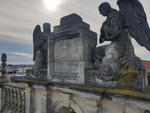
Digital Photograph: Cathedral of the Blessed Sacrament exterior angels
Images, Canterbury Museum
One digital photograph showing the two angels atop the Cathedral of the Blessed Sacrament. The plinth that supports the cross stands empty between the angels. Taken by the Catholic Diocese of Christchurch in August 2020 before the angels were salvaged from the building.
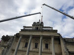
Digital Photograph: Cathedral of the Blessed Sacrament exterior angels sal…
Images, Canterbury Museum
One digital photograph showing the salvage of the exterior angels from the Cathedral of the Blessed Sacrament. Two crane arms and strapping around one of the angels can be seen in the photograph. Taken by the Catholic Diocese of Christchurch in September 2020.
Vegetation change and native forest restoration in urban environments: Man…
Research papers, Lincoln University
Global biodiversity is threatened by human actions, including in urban areas. Urbanisation has removed and fragmented indigenous habitats. As one of the 25 biodiversity ’hot spots’, New Zealand is facing the problems of habitat loss and indigenous species extinction. In New Zealand cities, as a result of the land clearance and imported urban planning precepts, many urban areas have little or no original native forest remaining. Urbanisation has also been associated with the introduction of multitudes of species from around the world. Two large earthquakes shook Christchurch in 2010 and 2011 and caused a lot of damage. Parts of the city suffered from soil liquefaction after the earthquakes. In the most damaged parts of Christchurch, particularly in the east, whole neighbourhoods were abandoned and later demolished except for larger trees. Christchurch offers an excellent opportunity to study the biodiversity responses to an urban area with less intensive management, and to learn more about the conditions in urban environments that are most conducive to indigenous plant biodiversity. This study focuses on natural woody plant regeneration of forested sites in Christchurch city, many of which were also surveyed prior to the earthquakes. By repeating the pre-earthquake surveys, I am able to describe the natural regeneration occurring in Christchurch forested areas. By combining this with the regeneration that has occurred in the Residential Red Zone, successional trajectories can be described under a range of management scenarios. Using a comprehensive tree map of the Residential Red Zone, I was also able to document minimum dispersal distances of a range of indigenous trees in Christchurch. This is important for planning reserve connectivity. Moreover, I expand and improve on a previous analysis of the habitat connectivity of Christchurch (made before the earthquakes) to incorporate the Residential Red Zone, to assess the importance for habitat connectivity of restoring the indigenous forest in this area. In combination, these data sets are used to provide patch scenarios and some management options for biodiversity restoration in the Ōtākaro-Avon Red Zone post-earthquake.
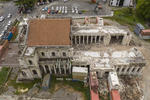
Digital Photograph: Cathedral of the Blessed Sacrament demolition
Images, Canterbury Museum
One digital photograph showing the demolition of the Cathedral of the Blessed Sacrament. A digger arm and nibbler claw can be seen in the photograph removing stone from the exterior, intact columns and ionic column capitals can be seen inside. Taken by the Catholic Diocese of Christchurch in September 2020.
The Rebuild 326-366
Images, eqnz.chch.2010
This is St Peters Riccarton. It was damaged in one of the two big Earthquakes to hit Christchurch in September 2010 and February 2011. Its taken a LONG time for work to really get going, but now that it is, they are also upgrading and extending the church with a modern annexe.
Help Is On The Way: TV doco remembers the 2011 Christchurch earthquake
Audio, Radio New Zealand
On 22 February 2011, Christchurch police sargeant Dave Harvey was outside the earthquake-damaged Hotel Grand Chancellor on Cashel Street, unsure if anyone was trapped inside. In case they were, he grabbed a can of spray paint and painted 'Help is on the way' in one-metre high letters on the road. Harvey's quick thinking really helped the people trapped in the hotel, says Clare Mackey, producer of the new documentary Help is on the Way.
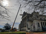
Digital Photograph: Cathedral of the Blessed Sacrament exterior angels sal…
Images, Canterbury Museum
One digital photograph showing a crane arm and workers in a cage during the salvage of the exterior angels from atop the Cathedral of the Blessed Sacrament. The large intact columns at the entrance of the Cathedral can be seen in the photograph. Taken by the Catholic Diocese of Christchurch in September 2020.
Transcript of Lois Mathie's earthquake story
Articles, UC QuakeStudies
A pdf transcript of Lois Mathie's second earthquake story, captured by the UC QuakeBox Take 2 project. Interviewer: Samuel Hope. Transcriber: Natalie Looyer.
Council apology doesn't make grief easier - Quake victim's daughter
Audio, Radio New Zealand
A Christchurch woman whose mother died in the 2011 earthquake says an apology from the Christchurch mayor Lianne Dalziel does not lessen her grief. Yesterday - nine years and one day since the quake killed 185 people - Dalziel invited their families for a private apology. She acknowledged errors made by engineers and the city council in regards to the CTV building. Julie Hibbs lost her mother in the collapse of the building. She speaks to Susie Ferguson.
3 - PLENARY 1 - Research in the Aftermath of the Christchurch Earthquakes:…
Research papers, University of Canterbury Library
QuakeStory 809
Articles, UC QuakeStudies
A story submitted by Anonymous to the QuakeStories website.
QuakeStory 810
Articles, UC QuakeStudies
A story submitted by Melody to the QuakeStories website.
QuakeStory 811
Articles, UC QuakeStudies
A story submitted by Anonymous to the QuakeStories website.
QuakeStory 812
Articles, UC QuakeStudies
A story submitted by Melody to the QuakeStories website.
National to confirm Auckland Central candidate by early Aug - Brownlee
Audio, Radio New Zealand
National's new deputy leader Gerry Brownlee discusses today's resignations from Nikki Kaye and Amy Adams, his track record in helping Christchurch earthquake claimants, and National's plans for the Auckland Central electorate.
House Talk | Episode 6: Lessons from the Rubble
Audio, Radio New Zealand
What are the lessons from the Christchurch earthquakes? The Government was slow in their quake response, but does that mean we should give more property market power to the private sector?
1,600 Canterbury homeowners with EQC quake claims open
Audio, Radio New Zealand
There are 1,600 Canterbury homeowners with earthquake claims still open with EQC. About 100 homeowners turned up to a meeting organised by EQC Fix in Christchurch on Monday night - all with stories of home repair hell, botched repairs, or seemingly never-ending arguments with EQC, Southern Response, or their private insurer. They were all tired and wondering why they still had to fight more than nine years on from the first Canterbury Earthquake. Checkpoint video journalist Logan Church travelled to Christchurch to speak to those still fighting for what they believe they are entitled too.
Lianne Dalziel apologises for earthquake deaths
Audio, Radio New Zealand
About two hundred of those who lost loved ones in collapsed buildings in Christchurch's 2011 earthquake, heard an apology from the city's mayor, Lianne Dalziel yesterday. A royal commission in to faulty buildings found serious errors by engineers and the Christchurch City Council 185 people died during the earthquake on the 22nd of February, 2011. David Selway who lost his sister Susan Selway in the CTV Building, said it was good to hear a heartfelt apology from the mayor for the role her council played in signing off the building as safe.
Redcliffs school moves to new site nine years after quakes
Audio, Radio New Zealand
A Christchurch primary school is moving into its permanent new home today, nine years after cliffs behind it collapsed during the city's earthquakes. Redcliffs School subsequently moved to a temporary location in the suburb of Sumner, but the new location will mean the school will return home to Redcliffs, after a land swap with the local park. The move comes after in 2016, the then National Government, overturned its own decision to close the school. Christchurch reporter Anan Zaki spoke to principal Rose McInerney ahead of today's move.
Discovery to buy Mediaworks' TV arm, TV news ratings wars
Audio, Radio New Zealand
Media commentator Andrew Holden joins Kathryn to talk about the move by Discovery Inc to buy Mediaworks' TV operations. When it comes to the TV news, why does TVNZ keep out-rating Newshub? And Munted, Stuff's video series for the 10th anniversary of the Christchurch earthquake, revisits 200 hours of original video footage in a new series narrated by Philip Matthews. Andrew Holden is a journalist for more than 30 years including five as Editor of The Press (in Christchurch) and four as Editor-in-Chief of The Age in Melbourne.
Transcript of Heather Bundy's earthquake story
Articles, UC QuakeStudies
A pdf transcript of Heather Bundy's second earthquake story, captured by the UC QuakeBox Take 2 project. Interviewer: Samuel Hope. Transcriber: Josie Hepburn.
EQC won’t extend deadline for claims for botched repairs
Audio, Radio New Zealand
Time is nearly up for owners of on-sold quake damaged properties in Canterbury to apply to claim money for botched repairs. The Government announced last year it would give an ex-gratia payment to home-owners with properties that went over the Earthquake Commission's then cap of $100,000. Today is the last day for applications after the original August deadline was extended due to Covid-19. But there are calls to extend that deadline again, as applications have flooded in over the past month.
Informing tsunami evacuation modelling by evacuation dynamics from Christc…
Research papers, University of Canterbury Library
Recent tsunami events have highlighted the importance of effective tsunami risk management strategies (including land-use planning, structural and natural mitigation, warning systems, education and evacuation planning). However, the rarity of tsunami means that empirical data concerning reactions to tsunami warnings and evacuation behaviour is rare when compared to findings for evacuations from other hazards. More knowledge is required to document the full evacuation process, including responses to warnings, pre-evacuation actions, evacuation dynamics, and the return home. Tsunami evacuation modelling has the potential to inform evidence-based tsunami risk planning and response. However, to date, tsunami evacuation models have largely focused on the timings of evacuations, rather than behaviours of those evacuating. In this research, survey data was gathered from coastal communities in Banks Peninsula and Christchurch, New Zealand, relating to behaviours and actions during the November 14th 2016 Kaikōura earthquake tsunami. Survey questions asked about immediate actions following the earthquake shaking, reactions to tsunami warnings, pre-evacuation actions, evacuation dynamics and details on congestion. This data was analysed to characterise trends and identify factors that influenced evacuation actions and behaviour, and was further used to develop a realistic evacuation model prototype to evaluate the capacity of the roading network in Banks Peninsula during a tsunami evacuation. The evacuation model incorporated tsunami risk management strategies that have been implemented by local authorities, and exposure and vulnerability data, alongside the empirical data collected from the survey. This research enhances knowledge of tsunami evacuation behaviour and reactions to tsunami warnings, and can be used to refine evacuation planning to ensure that people can evacuate efficiently, thereby reducing their tsunami exposure and personal risk.
How is the Christchurch rebuild influencing urban liveability? Central cit…
Research papers, University of Canterbury Library
This research attempts to understand how the Christchurch rebuild is promoting urban liveability in the Central City, focussing on the influence of communities and neighbourhoods in this area. To do this, gathering the perceptions of Christchurch residents through surveys, a focus group and semi-structured interviews was carried out to see what aspects they believe contribute to creating more liveable places. These methods revealed that there are pockets of neighbourhoods and communities in the inner-city, but no overall sense of community. Results from the semi-structured interviews reinforced this; the current buyers of inner-city property are in the financial position to be able to do this, and they seem to be purchasing in this area due to convenience and investment rather than to join the existing communities in the area. Analysing the survey responses from Central City residents revealed contrasting results. Those currently living in the area felt there is a sense of community in the inner-city, but these are found in pockets of neighbourhoods around the Central City rather than in the overall area. The focus group revealed that community is further prioritised later in life, and that many of the community groups in the inner-city predominantly consist of those who have lived there since before the Christchurch Earthquake Series. However, participants of all three methods believed that the Central City is slowly becoming a lively and vibrant place. To improve urban liveability in the inner-city, it seems that prioritisation of the needs of current inner-city residents is required. Improving these neighbourhoods, whether it be through the implementation of services or providing more communal spaces, is needed to create stronger communities. The feelings of place, connectedness, and belonging that arise from being part of a community or well-connected neighbourhood can improve mental health and wellbeing, ultimately enhancing the overall health of the population as well as the perceived urban liveability of the area.
The Christchurch Urban Design Panel: Its role and influence on residential…
Research papers, Lincoln University
During the 21st century, New Zealand has experienced increasing public concern over the quality of the design and appearance of new developments, and their effects on the urban environment. In response to this, a number of local authorities developed a range of tools to address this issue, including urban design panels to review proposals and provide independent advice. Following the 2010 and 2011 Canterbury earthquake sequence, the commitment to achieve high quality urban design within Christchurch was given further importance, with the city facing the unprecedented challenge of rebuilding a ‘vibrant and successful city’. The rebuild and regeneration reinforced the need for independent design review, putting more focus and emphasis on the role and use of the urban design panel; first through collaboratively assisting applicants in achieving a better design outcome for their development by providing an independent set of eyes on their design; and secondly in assisting Council officers in forming their recommendations on resource consent decisions. However, there is a perception that urban design and the role of the urban design panel is not fully understood, with some stakeholders arguing that Council’s urban design requirements are adding cost and complexity to their developments. The purpose of this research was to develop a better understanding on the role of the Christchurch urban design panel post-earthquake in the central city; its direct and indirect influence on the built environment; and the deficiencies in the broader planning framework and institutional settings that it might be addressing. Ultimately, the perceived role of the Panel is understood, and there is agreement that urban design is having a positive influence on the built environment, albeit viewed differently amongst the varying groups involved. What has become clear throughout this research is that the perceived tension between the development community and urban design well and truly exists, with the urban design panel contributing towards this. This tension is exacerbated further through the cost of urban design to developers, and the drive for financial return from their investments. The panel, albeit promoting a positive experience, is simply a ‘tick box’ exercise for some, and as the research suggests, groups or professional are determining themselves what constitutes good urban design, based on their attitude, the context in which they sit and the financial constraints to incorporate good design elements. It is perhaps a bleak time for urban design, and more about building homes.
Digital Photograph: Cathedral of the Blessed Sacrament partially demolished
Images, Canterbury Museum
One digital photograph showing the Cathedral of the Blessed Sacrament partially demolished. The interior is visible and lined with intact columns. Taken by photographer Helen McLeod in October 2020.
Digital Photograph: Cathedral of the Blessed Sacrament being demolished by…
Images, Canterbury Museum
One digital photograph showing the Cathedral of the Blessed Sacrament being demolished with a yellow digger. Taken by photographer Helen McLeod in September 2020.
Digital Photograph: Cathedral of the Blessed Sacrament interior during dem…
Images, Canterbury Museum
One digital photograph showing the Cathedral of the Blessed Sacrament interior during demolition. The nave columns are still intact but debris lines the floor. Taken by photographer Helen McLeod in November 2020.