Search
Images for Earthquake damage; more images...
Beckenham
Images, eqnz.chch.2010
None
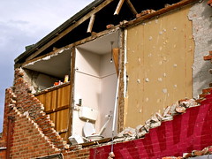
Earthquake damage to residental properties on Brook Street
Images, UC QuakeStudies
Earthquake damage to residental properties on Brook Street, Bexley.
Earthquake damage to a residential property in Bexley (2)
Images, UC QuakeStudies
Earthquake damage to a residential property in Bexley.
Digital Photograph: Earthquake damage to Church of the Most Holy Trinity, …
Images, Canterbury Museum
One landscape colour digital photograph taken on 25 February 2011 showing earthquake damage to the Anglican Church of The Most Holy Trinity in Winchester Street Lyttelton. Photograph shows the bracing to the northern transept erected after the 4 September 2010 earthquake. Architect The earthquake damaged northern wall of the Anglican Church of t...
Christchurch Earthquake
Images, eqnz.chch.2010
The old Robertson's Bakery building, Victoria Street, Christchurch
Christchurch Earthquake
Images, eqnz.chch.2010
The old Robertson's Bakery building, Victoria Street, Christchurch
Christchurch Earthquake
Images, eqnz.chch.2010
The old Robertson's Bakery building, Victoria Street, Christchurch
Christchurch Earthquake
Images, eqnz.chch.2010
The old Robertson's Bakery building, Victoria Street, Christchurch
Christchurch Earthquake
Images, eqnz.chch.2010
The old Robertson's Bakery building, Victoria Street, Christchurch
Christchurch Earthquake
Images, eqnz.chch.2010
The old Robertson's Bakery building, Victoria Street, Christchurch
Christchurch Earthquake
Images, eqnz.chch.2010
The old Robertson's Bakery building, Victoria Street, Christchurch
Christchurch Earthquake
Images, eqnz.chch.2010
The old Robertson's Bakery building, Victoria Street, Christchurch
Christchurch Earthquake
Images, eqnz.chch.2010
The old Robertson's Bakery building, Victoria Street, Christchurch
Christchurch Earthquake
Images, eqnz.chch.2010
The old Robertson's Bakery building, Victoria Street, Christchurch
Christchurch Earthquake
Images, eqnz.chch.2010
The old Robertson's Bakery building, Victoria Street, Christchurch
Christchurch Earthquake
Images, eqnz.chch.2010
The old Robertson's Bakery building, Victoria Street, Christchurch
Christchurch Earthquake
Images, eqnz.chch.2010
The old Robertson's Bakery building, Victoria Street, Christchurch
Christchurch Earthquake
Images, eqnz.chch.2010
The old Robertson's Bakery building, Victoria Street, Christchurch
Christchurch Earthquake
Images, eqnz.chch.2010
The old Robertson's Bakery building, Victoria Street, Christchurch
Christchurch Earthquake
Images, eqnz.chch.2010
The old Robertson's Bakery building, Victoria Street, Christchurch
Christchurch Earthquake
Images, eqnz.chch.2010
The old Robertson's Bakery building, Victoria Street, Christchurch
Christchurch Earthquake
Images, eqnz.chch.2010
The old Robertson's Bakery building, Victoria Street, Christchurch
Christchurch Earthquake
Images, eqnz.chch.2010
The old Robertson's Bakery building, Victoria Street, Christchurch
Christchurch Earthquake
Images, eqnz.chch.2010
The old Robertson's Bakery building, Victoria Street, Christchurch
Christchurch Earthquake
Images, eqnz.chch.2010
The old Robertson's Bakery building, Victoria Street, Christchurch
Christchurch Earthquake
Images, eqnz.chch.2010
The old Robertson's Bakery building, Victoria Street, Christchurch
Christchurch Earthquake
Images, eqnz.chch.2010
The old Robertson's Bakery building, Victoria Street, Christchurch
Transect Survey as a Post-Disaster Global Rapid Damage Assessment Tool
Research papers, The University of Auckland Library
Following a damaging earthquake, the immediate emergency response is focused on individual collapsed buildings or other "hotspots" rather than the overall state of damage. This lack of attention to the global damage condition of the affected region can lead to the reporting of misinformation and generate confusion, causing difficulties when attempting to determine the level of postdisaster resources required. A pre-planned building damage survey based on the transect method is recommended as a simple tool to generate an estimate of the overall level of building damage in a city or region. A methodology for such a transect survey is suggested, and an example of a similar survey conducted in Christchurch, New Zealand, following the 22 February 2011 earthquake is presented. The transect was found to give suitably accurate estimates of building damage at a time when information was keenly sought by government authorities and the general public. VoR - Version of Record
Damage on Oxford Terrace
Images, eqnz.chch.2010
Neighbours across the river showing earthquake damage. Hotel Grand Chancellor in the background. File reference: CCL-2011-08-12-CanterburyPublic Library pre-demolition-044 From the collection of Christchurch City Libraries.
Christchurch earthquake
Images, eqnz.chch.2010
The September Canterbury earthquake. These pictures were taken of Colombo Street in Sydenham. A lot of masonry in this area has been damaged/fallen down. The New Zealand Army, along with Police, were minding the cordons. Note: these photos were taken on a cellphone; mind the quality.


