
Search
found 3460 results
Images for 2011 Christchurch earthquake; more images...


Fairfax Video, February 2013 (3)
Videos, UC QuakeStudies
A video of interviews with four enterprising young Christchurch residents recorded two years after the 22 February 2011 earthquake. The video includes interviews with Gap Filler Director Coralie Winn, Arts Centre Director Andrew Lovatt, artist Mike Hewson, and Student Volunteer Army leader Jason Pembleton. The interviewees are asked four questions: 'What do you think Christchurch city centre will look like in 10 years?', 'What do you most want to see in the new city?', 'What do you miss most about the old city?', and 'What keeps you in Christchurch?'.
Question time for 17 May 2011
Audio, Radio New Zealand
Questions to Ministers 1. CRAIG FOSS to the Minister of Finance: What challenges does the Government face in putting together Budget 2011? 2. Dr RUSSEL NORMAN to the Prime Minister: Does he stand by his pre-Budget statement "The key sector which is not saving right now is the Government"; if so, what steps has he taken to increase government revenue? 3. Dr RUSSEL NORMAN to the Prime Minister: Does he stand by his statement "…we can use this time to transform the economy to make us stronger…"; if so, does this transformation involve an economy that uses fewer natural resources and produces less pollution? 4. Hon PHIL GOFF to the Prime Minister: Does he stand by all his statements on KiwiSaver? 5. NICKY WAGNER to the Minister for Canterbury Earthquake Recovery: What reports has he received on progress made to provide winter heating for residents affected by the Canterbury earthquakes? 6. Hon ANNETTE KING to the Prime Minister: What advice did he receive from the most recent food bank he visited about the current cost of living? 7. JACQUI DEAN to the Minister for the Environment: What practical initiatives is the Government taking in preparation for Rugby World Cup 2011 to protect the environment and New Zealand's important clean green brand? 8. Hon DAVID CUNLIFFE to the Minister of Finance: What was the annual rate of GDP growth for the year ended December 2010 projected in Budget 2010, and what was the actual rate of growth for that period according to Statistics New Zealand? 9. AARON GILMORE to the Minister of Education: What recent decisions have been made regarding schooling in Christchurch? 10. SUE MORONEY to the Minister of Education: When was construction completed on the new early childhood education centre at Weymouth Primary School and why is the centre empty? 11. COLIN KING to the Minister of Agriculture: What steps has the Government recently taken to support innovation in the Manuka honey industry? 12. CARMEL SEPULONI to the Minister of Justice: Does he stand by his statement "This Government is committed to ensuring that everyone…has access to justice"?
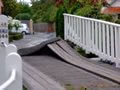
Too Big For Its Bridges
Images, UC QuakeStudies
An earthquake-damaged bridge, the approach to which has slumped. The photographer comments, "Due to lateral spread and the land slumping the road leading to this bridge has moved down greatly. Just imagine making the street lamps upright and how much that section of road would rise up at the end. When you go over bridges in the east side of Christchurch it is quite a climb up and a big drop down on the other side. The bridges in most cases coped very well, but not so the land leading to them".
Fairfax Video, February 2012 (5)
Videos, UC QuakeStudies
A video of interviews with primary and high-school students about their experiences during the 22 February 2011 earthquake. The students interviewed include (Paityn Ower from Avondale Primary School; Leah Temesvari, Ryan Cleaver, Jenna Hayes, and Logan Emery from Kaiapoi High School; Nikora Webster-Epiha, Grace Smith, and Natasha Gordon from Wainoni School; and Harry Loughan, Rebecca Lane, Scott Price, Maltin Tauave, Charlie Kavanagh, and Amy Sisson from Linwood College. This video was part of The Press's 'Christchurch, one year after February 22, 2011' series.
Key elements of sectoral recovery and resilience after the Canterbury eart…
Research papers, University of Canterbury Library
The Canterbury region of New Zealand experienced four earthquakes greater than MW 6.0 between September 2010 and December 2011. This study employs system dynamics as well as hazard, recovery and organisational literature and brings together data collected via surveys, case studies and interviews with organisations affected by the earthquakes. This is to show how systemic interactions and interdependencies within and between industry and geographic sectors affect their recovery post-disaster. The industry sectors in the study are: construction for its role in the rebuild, information and communication technology which is a regional high-growth industry, trucking for logistics, critical infrastructure, fast moving consumer goods (e.g. supermarkets) and hospitality to track recovery through non-discretionary and discretionary spend respectively. Also in the study are three urban centres including the region’s largest Central Business District, which has been inaccessible since the earthquake of 22 February 2011 to the time of writing in February 2013. This work also highlights how earthquake effects propagated between sectors and how sectors collaborated to mitigate difficulties such as product demand instability. Other interacting factors are identified that influence the recovery trajectories of the different industry sectors. These are resource availability, insurance payments, aid from central government, and timely and quality recovery information. This work demonstrates that in recovering from disaster it is crucial for organisations to identify what interacting factors could affect their operations. Also of importance are efforts to reduce the organisation’s vulnerability and increase their resilience to future crises and in day-to-day operations. Lastly, the multi-disciplinary approach to understanding the recovery and resilience of organisations and industry sectors after disaster, leads to a better understanding of effects as well as more effective recovery policy.
Our Changing World - Creating Waves
Audio, Radio New Zealand
After the devastating effects on Christchurch, we are all aware of the damage earthquakes can cause. But in New Zealand, a tsunami could be just as damaging. University of Auckland engineers Asaad Shamseldin and PhD student Reza Shafiei are creating waves in the lab to work out how safe our buildings are, if a tsunami hits. Ruth Beran goes to visit them.
Our Changing World - Heathcote River Recovery
Audio, Radio New Zealand
For six weeks after the February 2011 Christchurch earthquake millions of litres of raw sewage - along with lots of liquefaction - poured into the Avon and Heathcote Rivers. A team of biologists quickly got to work to measure the impact of this catastrophe on life in the Heathcote River and as they tell Alison Ballance, they were surprised by what they recorded over the next few months.
The Panel with Ali Jones and Gary McCormick (Part 1)
Audio, Radio New Zealand
On the 10th anniversary of the devastating 2011 Christchurch quake we hear the first-hand story from Zara Potts, who describes how the brick cafe she was in caved in around her; we hear from Dr Caroline Bell on how the earthquakes impacted the mental health of Cantabrians and how things are looking a decade later; and our panellists share their own memories from that day.
Kia Manawaroa: Surviving disaster: Experiences of Tangata Whaiora through …
Research Papers, Lincoln University
This report presents research on the affects of the Ōtautahi/Christchurch earthquakes of 2010 to 2012 on the city’s Tangata Whaiora community, ‘people seeking health’ as Māori frame mental health clients. Drawing on the voices of 39 participants of a Kaupapa Māori provider (Te Awa o te Ora), this report presents extended quotes from Tangata Whaiora, their support staff (many of whom are Tangata Whaiora), and managers as they speak of the events, their experiences, and support that sustained them in recoveries of well-being through the worse disaster in Aotearoa/New Zealand in three generations. Ōtautahi contains a significant urban Māori population, many living in suburbs that were seriously impacted by the earthquakes that began before dawn on September 4th, 2010, and continued throughout 2011 and 2012. The most damaging event occurred on February 22nd, 2011, and killed 185 people and severely damaged the CBD as well as many thousands of homes. The thousands of aftershocks delayed the rebuilding of homes and infrastructure and exacerbated the stress and dislocation felt by residents. The tensions and disorder continue for numerous residents into 2014 and it will be many years before full social and physical recovery can be expected. This report presents extended excerpts from the interviews of Tangata Whaiora and their support staff. Their stories of survival through the disaster reinforce themes of community and whānau while emphasising the reality that a significant number of Tangata Whaiora do not or cannot draw on this supports. The ongoing need for focused responses in the area of housing and accommodation, sufficiently resourced psycho-social support, and the value of Kaupapa Māori provision for Māori and non-Māori mental health clients cannot be overstated. The report also collates advice from participants to other Tangata Whaiora, their whānau, providers and indeed all residents of places subject to irregular but potentially devastating disaster. Much of this advice is relevant for more daily challenges and should not be underestimated despite its simplicity.
Looking Forward to a New Clay Bottom!
Images, UC QuakeStudies
A digitally manipulated photograph of the bottom of Victoria Lake in Hagley Park. The photographer comments, "After the Christchurch earthquake in February 2011, Victoria Lake suffered some cracking which broke the previous clay seal. The lake has now been excavated so that the new clay seal can be spread out and flattened ready to be filled again with water. The red pile is the clay and in the background is the grey silt or liquefaction that spewed into the lake from cracks in the lake bed".
The Cathedral has Developed a Bald Spot
Images, UC QuakeStudies
The Cathedral of the Blessed Sacrament after the dome was removed. Large cracks are visible in the walls and in the dome's supporting structure, and the facade is supported by haybales and shipping containers. The photographer comments, "The main dome of the Cathedral of the Blessed Sacrament became unsafe after the February Christchurch earthquake - workmen have slowly been dismantling it. Now we are just left with the cracked and twisted walls that supported the beautiful dome".
EQC report 'nothing new' - embattled Christchurch homeowner
Audio, Radio New Zealand
A Christchurch homeowner in a five year battle with the Earthquake Commission over the damaged house she unwittingly bought says a critical new report about EQC tells her nothing new. The 27 page review by Independent Ministerial Advisor Christine Stevenson looks at how to resolve the 3,600 claims that still haven't been settled after the 2010 and 2011 quakes. The recommendations include getting the Commission to hire more staff and to stop forcing people to use the Official Information Act to get their files. It also suggests giving EQC more power to settle the on-sold claims where people bought houses under the impression all damage had been identified and fixed. Georgina Hannafin has a home that needs $260,000 worth of repairs but EQC has offered her just $48,000.
Fairfax Video, September 2012 (5)
Videos, UC QuakeStudies
A video about several retail stores in Westfield Riccarton giving Christchurch women makeovers after the 22 February 2011 earthquake. Twenty-one women who were affected by the earthquakes or contributed to the recovery effort, were given a $1000 makeover by Blue Illusion, Rodney Wayne, Life Pharmacy, All About You, and Coffee Culture. The video includes an interview with Jude Kahui from Blue Illusion, who organised the makeovers. It also includes an interview with Shirley Quinn, one of the makeover recipients, as she receives her makeover.
Shake Table Testing of a Near Full Scale Three-storey Friction Based Low D…
Research papers, University of Canterbury Library
Recent severe earthquakes, such as the 2010-2011 Christchurch earthquake series, have put emphasis on building resilience all over the world. To achieve such resilience, procedures for low damage seismic design have been developed to satisfy both life safety requirements and the need to minimize undesirable economic effects of required building repair or structural member replacement following a major earthquake. Seismic resisting systems following this concept are expected to withstand severe earthquakes without requiring major post-earthquake repairs, using isolating mechanisms or sacrificial systems that either do not need repair or are readily repairable or replaceable. These include the sliding hinge joint with asymmetric friction connections (SHJAFCs) in beam-to-column connections of the moment resisting steel frames (MRSFs) and symmetric friction connections (SFCs) in braces of the braced frames. A 9 m tall, configurable three-storey steel framed composite floor building incorporating frictionbased connections is to be tested using two linked bi-directional shake tables at the International joint research Laboratory of Earthquake Engineering (ILEE) facilities, Shanghai, China. The structural systems are configurable, allowing different moment and braced frame structural systems tested in two horizontal directions. The structure is designed and detailed to undergo, at worst, minor damage under a planned series of severe earthquakes.
20160703_144759_GT-S7275T-04 New sea wall at Redcliffs (185/366)
Images, eqnz.chch.2010
20160703_144759_GT-S7275T-04 New sea wall at Redcliffs (185/366) I went for a drive in my second car mainly to charge the battery up and forgot to take my camera gear so only had my phone. This is the new rock wall to replace the severely damaged previous one (in the February 2011 earthquake). Work is still underway on the car parking and p...
Emergency management planning: Waimakariri District Council response and r…
Research Papers, Lincoln University
The New Zealand Kellogg Rural Leaders Programme develops emerging agribusiness leaders to help shape the future of New Zealand agribusiness and rural affairs. Lincoln University has been involved with this leaders programme since 1979 when it was launched with a grant from the Kellogg Foundation, USA.At 4.35am on 4th September 2010, Canterbury was hit by an earthquake measuring 7.1 on the Richter scale. On 22nd February 2011 and 13th June 2011 a separate fault line approximately 35km from the first, ruptured to inflict two further earthquakes measuring 6.3 and 6.0 respectively. As a direct result of the February earthquake, 181 people lost their lives. Some commentators have described this series of earthquakes as the most expensive global insurance event of all time. These earthquakes and the more than 7000 associated aftershocks have had a significant physical impact on parts of Canterbury and virtually none on others. The economic, social and emotional impacts of these quakes spread across Canterbury and beyond. Waimakariri district, north of Christchurch, has reflected a similar pattern, with over 1400 houses requiring rebuild or substantial repair, millions of dollars of damage to infrastructure, and significant social issues as a result. The physical damage in Waimakiriri District was predominately in parts of Kaiapoi, and two small beach settlements, The Pines and Kairaki Beach with pockets elsewhere in the district. While the balance of the district is largely physically untouched, the economic, social, and emotional shockwaves have spread across the district. Waimakariri district consists of two main towns, Rangiora and Kaiapoi, a number of smaller urban areas and a larger rural area. It is considered mid-size in the New Zealand local government landscape. This paper will explore the actions and plans of Waimakiriri District Council (WDC) in the Emergency Management Recovery programme to provide context to allow a more detailed examination of the planning processes prior to, and subsequent to the earthquakes. This study looked at documentation produced by WDC, applicable legislation and New Zealand Emergency Management resources and other sources. Key managers and elected representatives in the WOC were interviewed, along with a selection of governmental and nongovernmental agency representatives. The interview responses enable understanding of how central Government and other local authorities can benefit from these lessons and apply them to their own planning. It is intended that this paper will assist local government organisations in New Zealand to evaluate their planning processes in light of the events of 2010/11 in Canterbury and the lessons from WDC.
Southern Story for 22 August 2013 - 37
Audio, Radio New Zealand
A new exhibition is simply called " 37". The show is by the photographer Doc Ross, features 37 Christchurch people captured on film using a 37 second exposure. The aim: to reflect the length of time their city shook during February 2011's devastating earthquake. Katy Gosset hears some of the stories behind the exhibition and hits the streets to record her own take on the 37 second concept.
Report on the ‘Project Masonry’ recovery project
Research papers, The University of Auckland Library
As part of the ‘Project Masonry’ Recovery Project funded by the New Zealand Natural Hazards Research Platform, commencing in March 2011, an international team of researchers was deployed to document and interpret the observed earthquake damage to masonry buildings and to churches as a result of the 22nd February 2011 Christchurch earthquake. The study focused on investigating commonly encountered failure patterns and collapse mechanisms. A brief summary of activities undertaken is presented, detailing the observations that were made on the performance of and the deficiencies that contributed to the damage to approximately 650 inspected unreinforced clay brick masonry (URM) buildings, to 90 unreinforced stone masonry buildings, to 342 reinforced concrete masonry (RCM) buildings, to 112 churches in the Canterbury region, and to just under 1100 residential dwellings having external masonry veneer cladding. Also, details are provided of retrofit techniques that were implemented within relevant Christchurch URM buildings prior to the 22nd February earthquake. In addition to presenting a summary of Project Masonry, the broader research activity at the University of Auckland pertaining to the seismic assessment and improvement of unreinforced masonry buildings is outlined. The purpose of this outline is to provide an overview and bibliography of published literature and to communicate on-going research activity that has not yet been reported in a complete form. http://sesoc.org.nz/conference/programme.pdf
Liquefaction and Paleo-liquefaction in Christchurch, New Zealand
Research papers, University of Canterbury Library
Liquefaction during the 4th September 2010 Mw 7.1 Darfield earthquake and large aftershocks in 2011 (Canterbury earthquake sequence, CES) caused severe damage to land and infrastructure within Christchurch, New Zealand. Approximately one third of the total CES-induced financial losses were directly attributable to liq- uefaction and thus highlights the need for local and regional authorities to assess liquefaction hazards for present and future developments. This thesis is the first to conduct paleo-liquefaction studies in eastern Christchurch for the purpose of de- termining approximate return times of liquefaction-inducing earthquakes within the region. The research uncovered evidence for pre-CES liquefaction dated by radiocarbon and cross-cutting relationships as post-1660 to pre-1905. Additional paleo-liquefaction investigations within the eastern Christchurch suburb of Avon- dale, and the northern township of Kaiapoi, revealed further evidence for pre-CES liquefaction. Pre-CES liquefaction in Avondale is dated as post-1321 and pre-1901, while the Kaiapoi features likely formed during three distinct episodes: post-1458 and possibly during the 1901 Cheviot earthquake, post-1297 to pre-1901, and pre-1458. Evaluation of the liquefaction potential of active faults within the Can- terbury region indicates that many faults have the potential to cause widespread liquefaction within Avondale and Kaiapoi. The identification of pre-CES liquefac- tion confirms that these areas have previously liquefied, and indicates that residen- tial development in eastern Christchurch between 1860 and 2005 occurred in areas containing geologic evidence for pre-CES liquefaction. Additionally, on the basis of detailed field and GIS-based mapping and geospatial-statistical analysis, the distribution and severity of liquefaction and lateral spreading within the eastern Christchurch suburb of Avonside is shown in this study to be strongly in uenced by geomorphic and topographic variability. This variability is not currently ac- counted for in site-specific liquefaction assessments nor the simplified horizontal displacement models, and accounts for some of the variability between the pre- dicted horizontal displacements and those observed during the CES. This thesis highlights the potential applications of paleo-liquefaction investigations and ge- omorphic mapping to seismic and liquefaction hazard assessments and may aid future land-use planning decisions.
Body, Guy Keverne, 1967-:The week... 15 December 2012
Images, Alexander Turnbull Library
Four cartoons in the same frame commenting on news and happenings in the week ending 15 December 2011. The cartoons refer to the expulsion of the controversial Member of Parliament, Brendan Horan, from the New Zealand First Party by its leader, Winston Peters; the stereotyping of New Zealand as being 'Middle Earth' following the filming of 'The Hobbit', punned as 'The Habbit'; the lax attitude to building design and standards, which led to the CTV Building disaster in the Christchurch earthquake; the news about the New Zealand SPCA teaching dogs to drive. Quantity: 1 digital cartoon(s).
Fairfax Video, June 2012 (2)
Videos, UC QuakeStudies
A video of an interview with Jenny Beecroft and Warren Beecroft about the housing shortage in Christchurch. Jenny's daughter Selena Beecroft had to move into Jenny's house with her two sons after the 22 February 2011 earthquake damaged her rental property. Selena has epilepsy and can only move into a rental property in walking distance of her work and her children's school. The family is one of many living in difficult situations despite the government's claim that there is no housing crisis in Christchurch.
Question Time for 24 March 2011
Audio, Radio New Zealand
Questions to Ministers 1. JACQUI DEAN to the Minister of Finance: What reports has he received on the economy? 2. Hon PHIL GOFF to the Prime Minister: Will he rule out making cuts to Working for Families payments this year; if not, why not? 3. TIM MACINDOE to the Minister for Social Development and Employment: What changes is the Government making to Family Start to ensure a greater focus on protecting children from abuse and neglect? 4. Hon ANNETTE KING to the Minister for Social Development and Employment: Does she agree with the Prime Minister that "anyone on a benefit actually has a lifestyle choice…some make poor choices, and they do not have money left"? 5. KANWALJIT SINGH BAKSHI to the Minister of Civil Defence: Did he meet with business leaders in Christchurch yesterday to discuss the Civil Defence state of national emergency operations; if so, what was the outcome of that meeting? 6. Hon DAVID CUNLIFFE to the Minister of Finance: Who was right, the Prime Minster who predicted that the New Zealand economy would grow "reasonably aggressively" in 2010-11, or the last four quarterly NZIER consensus forecast updates for GDP, which have progressively declined from 3.2 percent to just 0.8 percent for the year to March 2011? 7. Dr RUSSEL NORMAN to the Minister of Finance: Which response to the Christchurch earthquake carries a greater risk of a credit downgrade: increased government borrowing or a temporary earthquake levy? 8. PHIL TWYFORD to the Minister of Local Government: When he said "Auckland's fragmented governance has meant a lack [of] leadership and vision, but soon its leaders will be able to think regionally, plan strategically and act decisively", did he mean only if they agree with the Government's plan for Auckland? 9. JO GOODHEW to the Minister of Education: What were the results of the Accelerating Learning in Mathematics Pilot Study? 10. Hon DAMIEN O'CONNOR to the Minister for Biosecurity: Does he agree with the statements made by John Lancashire and Stew Wadey, President of Waikato Federated Farmers, in the Dominion Post yesterday that New Zealand is exposed to greater risk of incursions or exotic pests at our borders as a result of the "fast-tracking of tourists", the "attempts to abolish import restrictions", and his axing of 60 frontline border staff? 11. MICHAEL WOODHOUSE to the Acting Minister of Energy and Resources: What reports has she received on levels of renewable electricity generation? 12. CHRIS HIPKINS to the Minister for ACC: Does he stand by his answer to question 4 on Thursday last week "that funding will be taken from either the earners account or the work account" and "that a higher proportion of claims than the overall average for ACC are actually in the work account"; if not, why not?
20130901_2862_1D3-175 7:26am
Images, eqnz.chch.2010
Demolition of the support structure for NZ Breweries smokestack in Christchurch. CERES NZ's nibbler is at work, the pipe stack having been removed yesterday (Saturday). I retuned three hours later to see what progress had been made and it was GONE! See next photo. Damage to complex was from the 22/02/20011 earthquake.
20131231_8509_EOS M-22 Forsyth Barr building with remains of PWC just behi…
Images, eqnz.chch.2010
20131231_8509_EOS M-22 Forsyth Barr building with remains of PWC just behind the green fence (across river) Another city walk around, this time with my brother-in-law from Auckland. Also went to the Quake City exhibition in the city organised by the Canterbury Museum. First fine day for a while. #4506
20131231_8504_EOS M-22 Looking up Cashel Street
Images, eqnz.chch.2010
20131231_8504_EOS M-22 Looking up Cashel Street Another city walk around, this time with my brother-in-law from Auckland. Also went to the Quake City exhibition in the city organised by the Canterbury Museum. First fine day for a while. For 36 years I worked in a now gone building where that red car is parked (on the left). and would have wa...
20131231_8513_EOS M-22 The chocolate double decker
Images, eqnz.chch.2010
20131231_8513_EOS M-22 The chocolate double decker Another city walk around, this time with my brother-in-law from Auckland. Also went to the Quake City exhibition in the city organised by the Canterbury Museum. First fine day for a while. This bus is used as a chocolate restaurant, and is parked next to the Pallet Pavilion on the site of th...
20130511_1535_EOS M-22 Captain Cook (Day 131/365)
Images, eqnz.chch.2010
The statue of Captain Cook looks over an empty Victoria Square with autumn leaves lying around. This used to be a very tidy and busy area, but is now nearly all fenced off. Pedestrian access to this section was established about five or six months ago.
An inventory of community-led recovery initiatives in Canterbury
Research Papers, Lincoln University
Though there is a broad consensus that communities play a key role in disaster response and recovery, most of the existing work in this area focuses on the activities of donor agencies, formal civil defence authorities, and local/central government. Consequently, there is a paucity of research addressing the on-going actions and activities undertaken by communities and ‘emergent groups’ , particularly as they develop after the immediate civil defence or ‘response’ phase is over. In an attempt to address this gap, this inventory of community-led recovery initiatives was undertaken approximately one year after the most devastating February 2011 earthquake. It is part of on-going project at Lincoln University documenting – and seeking a better understanding of - various emergent communities’ roles in recovery, their challenges, and strategies for overcoming them. This larger project also seeks to better understand how collaborative work between informal and formal recovery efforts might be facilitated at different stages of the process. This inventory was conducted over the December 2011 – February 2012 period and builds on Landcare Research’s Christchurch Earthquake Activity Inventory which was a similar snapshot taken in April 2011. The intention behind conducting this updated inventory is to gain a longitudinal perspective of how community-led recovery activities evolve over time. Each entry is ordered alphabetically and contact details have been provided where possible. A series of keywords have also been assigned that describe the main attributes of each activity to assist searches within this document.This inventory was supported by the Lincoln University Research Fund and the Royal Society Marsden Fund.
Panel connection details in existing New Zealand precast concrete buildings
Research papers, The University of Auckland Library
Following the 2010/2011 Canterbury earthquakes the seismic design of buildings with precast concrete panels has received significant attention. Although this form of construction generally performed adequately in Christchurch, there were a considerable number of precast concrete panel connection failures. This observation prompted a review of more than 4700 panel details from 108 buildings to establish representative details used in both existing and new multi-storey and low rise industrial precast concrete buildings in three major New Zealand cities of Auckland, Wellington and Christchurch. Details were collected from precast manufacturers and city councils and were categorised according to type. The detailing and quantity of each reviewed connection type in the sampled data is reported, and advantages and potential deficiencies of each connection type are discussed. The results of this survey provide a better understanding of the relative prevalence of common detailing used in precast concrete panels and guidance for the design of future experimental studies. http://www.nzsee.org.nz/publications/nzsee-quarterly-bulletin/
Geologic and anthropogenic influences on rockfall and liquefaction in the …
Research papers, University of Canterbury Library
Geologic phenomena produced by earthquake shaking, including rockfalls and liquefaction features, provide important information on the intensity and spatiotemporal distribution of earthquake ground motions. The study of rockfall and liquefaction features produced in contemporary well- instrumented earthquakes increases our knowledge of how natural and anthropogenic environments respond to earthquakes and improves our ability to deduce seismologic information from analogous pre-contemporary (paleo-) geologic features. The study of contemporary and paleo- rockfall and liquefaction features enables improved forecasting of environmental responses to future earthquakes. In this thesis I utilize a combination of field and imagery-based mapping, trenching, stratigraphy, and numerical dating techniques to understand the nature and timing of rockfalls (and hillslope sedimentation) and liquefaction in the eastern South Island of New Zealand, and to examine the influence that anthropogenic activity has had on the geologic expressions of earthquake phenomena. At Rapaki (Banks Peninsula, NZ), field and imagery-based mapping, statistical analysis and numerical modeling was conducted on rockfall boulders triggered by the fatal 2011 Christchurch earthquakes (n=285) and compared with newly identified prehistoric (Holocene and Pleistocene) boulders (n=1049) deposited on the same hillslope. A significant population of modern boulders (n=26) travelled farther downslope (>150 m) than their most-travelled prehistoric counterparts, causing extensive damage to residential dwellings at the foot of the hillslope. Replication of prehistoric boulder distributions using 3-dimensional rigid body numerical models requires the application of a drag-coefficient, attributed to moderate to dense slope vegetation, to account for their spatial distribution. Radiocarbon dating provides evidence for 17th to early 20th century deforestation at the study site during Polynesian and European colonization and after emplacement of prehistoric rockfalls. Anthropocene deforestation enabled modern rockfalls to exceed the limits of their prehistoric predecessors, highlighting a shift in the geologic expression of rockfalls due to anthropogenic activity. Optical and radiocarbon dating of loessic hillslope sediments in New Zealand’s South Island is used to constrain the timing of prehistoric rockfalls and associated seismic events, and quantify spatial and temporal patterns of hillslope sedimentation including responses to seismic and anthropogenic forcing. Luminescence ages from loessic sediments constrain timing of boulder emplacement to between ~3.0 and ~12.5 ka, well before the arrival of Polynesians (ca AD 1280) and Europeans (ca AD 1800) in New Zealand, and suggest loess accumulation was continuing at the study site until 12-13 ka. Large (>5 m3) prehistoric rockfall boulders preserve an important record of Holocene hillslope sedimentation by creating local traps for sediment aggradation and upbuilding soil formation. Sediment accumulation rates increased considerably (>~10 factor increase) following human arrival and associated anthropogenic burning of hillslope vegetation. New numerical ages are presented to place the evolution of loess-mantled hillslopes in New Zealand’s South Island into a longer temporal framework and highlight the roles of earthquakes and humans on hillslope surface process. Extensive field mapping and characterization for 1733 individual prehistoric rockfall boulders was conducted at Rapaki and another Banks Peninsula site, Purau, to understand their origin, frequency, and spatial and volumetric distributions. Boulder characteristics and distributions were compared to 421 boulders deposited at the same sites during the 2010-2011 Canterbury earthquake sequence. Prehistoric boulders at Rapaki and Purau are comprised of two dominant lithofacies types: volcanic breccia and massive (coherent) lava basalt. Volcanic breccia boulders are found in greatest abundance (64-73% of total mapped rockfall) and volume (~90-96% of total rockfall) at both locations and exclusively comprise the largest boulders with the longest runout distances that pose the greatest hazard to life and property. This study highlights the primary influence that volcanic lithofacies architecture has on rockfall hazard. The influence of anthropogenic modifications on the surface and subsurface geologic expression of contemporary liquefaction created during the 2010-2011 Canterbury earthquake sequence (CES) in eastern Christchurch is examined. Trench observations indicate that anthropogenic fill layer boundaries and the composition/texture of discretely placed fill layers play an important role in absorbing fluidized sand/silt and controlling the subsurface architecture of preserved liquefaction features. Surface liquefaction morphologies (i.e. sand blows and linear sand blow arrays) display alignment with existing utility lines and utility excavations (and perforated pipes) provided conduits for liquefaction ejecta during the CES. No evidence of pre-CES liquefaction was identified within the anthropogenic fill layers or underlying native sediment. Radiocarbon dating of charcoal within the youngest native sediment suggests liquefaction has not occurred at the study site for at least the past 750-800 years. The importance of systematically examining the impact of buried infrastructure on channelizing and influencing surface and subsurface liquefaction morphologies is demonstrated. This thesis highlights the importance of using a multi-technique approach for understanding prehistoric and contemporary earthquake phenomena and emphasizes the critical role that humans play in shaping the geologic record and Earth’s surface processes.