Search
found 316 results
Images for [empty query]; more images...


Urban comfort in a future compact city: Analysis of open-space qualities i…
Research papers, Lincoln University
The increase in urban population has required cities to rethink their strategies for minimising greenhouse gas impacts and adapting to climate change. While urban design and planning policy have been guided by principles such as walkability (to reduce the dependence on cars) and green infrastructure (to enhance the quality of open spaces to support conservation and human values), there have been conflicting views on what spatial strategies will best prepare cities for a challenging future. Researchers supporting compact cities based upon public Transit Oriented Development have claimed that walkability, higher density and mixed-uses make cities more sustainable (Owen, 2009) and that, while green spaces in cities are necessary, they are dull in comparison with shopfronts and street vendors (Speck, 2012, p 250). Other researchers claim that green infrastructure is fundamental to improving urban sustainability and attracting public space users with improved urban comfort, consequently encouraging walkability (Pitman and Ely, 2013). Landscape architects tend to assume that ‘the greener the better’; however, the efficiency of urban greenery in relation to urban comfort and urbanity depends on its density, distribution and the services provided. Green infrastructure can take many forms (from urban forests to street trees) and provide varied services (amended microclimate, aesthetics, ecology and so forth). In this paper, we evaluate the relevance of current policy in Christchurch regarding both best practice in green infrastructure and urban comfort (Tavares, 2015). We focus on the Christchurch Blueprint for rebuilding the central city, and critically examine the post-earthquake paths the city is following regarding its green and grey infrastructures and the resulting urban environment. We discuss the performance and appropriateness of the current Blueprint in post-earthquake Christchurch, particularly as it relates to the challenges that climate change is creating for cities worldwide.
Building resilience in transient rural communities – a post-earthquake reg…
Research papers, Lincoln University
The Kaikoura earthquake in November 2016 highlighted the vulnerability of New Zealand’s rural communities to locally-specific hazard events, which generate regional and national scale impacts. Kaikoura was isolated with significant damage to both the east coast road (SH1) and rail corridor, and the Inland Road (Route 70). Sea bed uplift along the coast was significant – affecting marine resources and ocean access for marine operators engaged in tourism and harvesting, and recreational users. While communities closest to the earthquake epicentre (e.g., Kaikoura, Waiau, Rotherham and Cheviot) suffered the most immediate earthquake damage, the damage to the transport network, and the establishment of an alternative transport route between Christchurch and Picton, has significantly impacted on more distant communities (e.g., Murchison, St Arnaud and Blenheim). There was also considerable damage to vineyard infrastructure across the Marlborough region and damage to buildings and infrastructure in rural settlements in Southern Marlborough (e.g., Ward and Seddon).
Lessons learned from liquefaction of the Canterbury Earthquake Sequence (2…
Research papers, Lincoln University
Liquefaction affects late Holocene, loose packed and water saturated sediment subjected to cyclical shear stress. Liquefaction features in the geological record are important off-fault markers that inform about the occurrence of moderate to large earthquakes (> 5 Mw). The study of contemporary liquefaction features provides a better understanding of where to find past (paleo) liquefaction features, which, if identified and dated, can provide information on the occurrence, magnitude and timing of past earthquakes. This is particularly important in areas with blind active faults. The extensive liquefaction caused by the 2010-2011 Canterbury Earthquake Sequence (CES) gave the geoscience community the opportunity to study the liquefaction process in different settings (alluvial, coastal and estuarine), investigating different aspects (e.g. geospatial correlation with landforms, thresholds for peak ground acceleration, resilience of infrastructures), and to collect a wealth geospatial dataset in the broad region of the Canterbury Plains. The research presented in this dissertation examines the sedimentary architecture of two environments, the alluvial and coastal settings, affected by liquefaction during the CES. The novel aim of this study is to investigate how landform and subsurface sedimentary architecture influence liquefaction and its surface manifestation, to provide knowledge for locating studies of paleoliquefaction in future. Two study cases documented in the alluvial setting showed that liquefaction features affected a crevasse splay and point bar ridges. However, the liquefaction source layer was linked to paleochannel floor deposits below the crevasse splay in the first case, and to the point bar deposits themselves in the second case. This research documents liquefaction features in the coastal dune system of the Canterbury Plains in detail for the first time. In the coastal dune setting the liquefiable layer is near the surface. The pore water pressure is vented easily because the coastal dune soil profile is entirely composed of non-cohesive, very well sorted sandy sediment that weakly resists disturbance from fluidised sediment under pressure. As a consequence, the liquefied flow does not need to find a specific crack through which the sediment is vented at the surface; instead, the liquefied sand finds many closely spaced conduits to vent its excess of pore water pressure. Therefore, in the coastal dune setting it is rare to observe discrete dikes (as they are defined in the alluvial setting), instead A horizon delamination (splitting) and blistering (near surface sills) are more common. The differences in styles of surface venting lead to contrasts in patterns of ejecta in the two environments. Whereas the alluvial environment is characterised by coalesced sand blows forming lineations, the coastal dune environment hosts apparently randomly distributed isolated sand blows often associated with collapse features. Amongst the techniques tested for the first time to investigate liquefaction features are: 3D GPR, which improved the accuracy of the trenching even six years after the liquefaction events; thin section analysis to investigate sediment fabric, which helped to discriminate liquefied sediment from its host sediment, and modern from paleoliquefaction features; a Random Forest classification based on the CES liquefaction map, which was used to test relationships between surface manifestation of liquefaction and topographic parameters. The results from this research will be used to target new study sites for future paleoliquefaction research and thus will improve the earthquake hazard assessment across New Zealand.
What is the place of nature in the urban regeneration of central Christchu…
Research papers, Lincoln University
Please contact supervisor Lin Roberts at Lincoln University to request a copy of this dissertation to read.Cities around the world are becoming greener, with many striving to make their cities as green as possible. Christchurch was devastated by an Earthquake in 2011, which resulted in many fatalities. Though this impacted the city negatively, this sad event was used as an opportunity for the broken city to become a better one. The Christchurch City Council (CCC) ran an exercise called ‘Share an Idea’, which asked the public what they wanted the new city to look like. The main theme extrapolated by researchers was that people wanted the city to be greener. A draft plan was created by the CCC but was deemed not good enough and replaced by a new plan called the Blueprint Plan created by the government. Through the process of public consultation to the finalized plan and the implementation of the finalized plan, there were many changes made to the inclusion of nature into Central Christchurch’s urban regeneration. The aim of this research is to assess the role of nature in the urban regeneration of Christchurch, by evaluating the recovery process, and comparing the level of greenness the public wanted by looking at what they said in Share an Idea, and then seeing how that translated into the proposed plans, and then finally looking at what is being implemented.
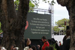
Digital Photograph: Brass Band at the Canterbury Earthquake Memorial Servi…
Images, Canterbury Museum
One landscape colour digital photograph taken 22 February 2017 showing brass band members at the Canterbury Earthquake Memorial Service. Behind the band is a digital screen showing words of thanks from survivors.
Digital Photograph: Guests Arriving at the Canterbury Earthquake Memorial …
Images, Canterbury Museum
One landscape colour digital photograph taken 22 February 2017 showing guests being seated prior to the Canterbury Earthquake Memorial Service.
Digital Photograph: First Responders at the Canterbury Earthquake Memorial…
Images, Canterbury Museum
One landscape colour digital photograph taken 22 February 2017 showing first responders at the Canterbury Earthquake Memorial Service.
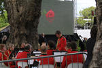
Digital Photograph: Brass Band at the Canterbury Earthquake Memorial Servi…
Images, Canterbury Museum
One landscape colour digital photograph taken 22 February 2017 showing brass band members at the Canterbury Earthquake Memorial Service. Behind the band is a digital screen showing an image of flowers floating in the Avon River.
Digital Photograph: Members of the Media at the Canterbury Earthquake Memo…
Images, Canterbury Museum
One landscape colour digital photograph taken 22 February 2017 showing cameramen and journalists at the Canterbury Earthquake Memorial Service.
Digital Photograph: Media Viewing Area at the Canterbury Earthquake Memori…
Images, Canterbury Museum
One landscape colour digital photograph taken 22 February 2017 showing the appointed media viewing area at the Canterbury Earthquake Memorial Service.
Digital Photograph: First Responders and Public Viewing Areas at the Cante…
Images, Canterbury Museum
One landscape colour digital photograph taken 22 February 2017 showing the appointed first responders and public viewing areas at the Canterbury Earthquake Memorial Service.
Digital Photograph: First Responders Laying Wreaths at the Canterbury Eart…
Images, Canterbury Museum
One landscape colour digital photograph taken 22 February 2017 showing first responders laying wreaths at the Canterbury Earthquake Memorial Service.
Digital Photograph: Commemoration Board at the Canterbury Earthquake Memor…
Images, Canterbury Museum
One landscape colour digital photograph taken 22 February 2017 showing a gentleman reading messages on a commemoration board at the Canterbury Earthquake Memorial Service.
Digital Photograph: Flowers Floating in the Avon River
Images, Canterbury Museum
One landscape colour digital photograph taken 22 February 2017 showing flowers floating in the Avon River as part of the Canterbury Earthquake Memorial Service.
Digital Photograph: Sunflower Atop a Road Works Cone
Images, Canterbury Museum
One landscape colour digital photograph taken 22 February 2017 showing a sunflower sitting atop a road works cone as part of the Canterbury Earthquake Memorial Service.
Digital Photograph: Earthquake Memorial Trellis
Images, Canterbury Museum
One landscape colour digital photograph taken 22 February 2017 showing an earthquake memorial trellis at the site of the former Canterbury Television building.
Digital Photograph: Commemorative Note to Andrew Bishop
Images, Canterbury Museum
One landscape colour digital photograph taken 22 February 2017 showing a commemorative note to, and photograph of, Andrew Bishop attached to an earthquake memorial trellis at the site of the former Canterbury Television building.
Digital Photograph: Flowers on an Earthquake Memorial Trellis
Images, Canterbury Museum
One landscape colour digital photograph taken 22 February 2017 showing a bouquet of flowers and a note attached to an earthquake memorial trellis at the site of the former Canterbury Television building.
Digital Photograph: Earthquake Memorial Trellis
Images, Canterbury Museum
One landscape colour digital photograph taken 22 February 2017 showing an earthquake memorial trellis at the site of the former Canterbury Television building.
Digital Photograph: Karen Bishop at an Earthquake Memorial Trellis
Images, Canterbury Museum
One landscape colour digital photograph taken 22 February 2017 showing Karen Bishop attaching a windmill to an earthquake memorial trellis in memory of her son Andrew Bishop at the site of the former Canterbury Television building.
Digital Photograph: Windmill Attached to an Earthquake Memorial Trellis
Images, Canterbury Museum
One landscape colour digital photograph taken 22 February 2017 showing a windmill attached to an earthquake memorial trellis by Karen Bishop in memory of her son Andrew Bishop at the site of the former Canterbury Television building.
Digital Photograph: Flowers at the Site of the Former Canterbury Televisio…
Images, Canterbury Museum
One landscape colour digital photograph taken 22 February 2017 showing a bouquet of flowers left at the site of the former Canterbury Television building by the Toyama Language School in memory of earthquake victims.
Digital Photograph: Flowers at the Site of the Former Canterbury Televisio…
Images, Canterbury Museum
One landscape colour digital photograph taken 22 February 2017 showing bouquets of flowers and gifts left at the site of the former Canterbury Television building in memory of earthquake victims.
Digital Photograph: Flowers at the Site of the Former Canterbury Televisio…
Images, Canterbury Museum
One landscape colour digital photograph taken 22 February 2017 showing a bouquet of flowers left at the site of the former Canterbury Television building by St John New Zealand in memory of earthquake victims and in appreciation of first responders.
Empirical vulnerability assessment of reinforced concrete frame with mason…
Research papers, The University of Auckland Library
During the 2010/2011 Canterbury earthquakes, Reinforced Concrete Frame with Masonry Infill (RCFMI) buildings were subjected to significant lateral loads. A survey conducted by Christchurch City Council (CCC) and the Canterbury Earthquake Recovery Authority (CERA) documented 10,777 damaged buildings, which included building characteristics (building address, the number of storeys, the year of construction, and building use) and post-earthquake damage observations (building safety information, observed damage, level of damage, and current state of the buildings). This data was merged into the Canterbury Earthquake Building Assessment (CEBA) database and was utilised to generate empirical fragility curves using the lognormal distribution method. The proposed fragility curves were expected to provide a reliable estimation of the mean vulnerability for commercial RCFMI buildings in the region http://www.13thcms.com/wp-content/uploads/2017/05/Symposium-Info-and-Presentation-Schedule.pdf VoR - Version of Record
Between Grey and Green: Ecological Resilience in Urban Landscapes
Research papers, The University of Auckland Library
This paper analyses the city of Christchurch, New Zealand, which has been through dramatic changes since it was struck by a series of earthquakes of different intensities between 2010 and 2011. The objective is to develop a deeper understanding of resilience by looking at changes in green and grey infrastructures. The study can be helpful to reveal a way of doing comparative analysis using resilience as a theoretical framework. In this way, it might be possible to assess the blueprint of future master plans by considering how important the interplay between green and grey infrastructure is for the resilience capacity of cities
Soil-Foundation-Structure Interaction in the Earthquake Performance of Mul…
Research papers, The University of Auckland Library
The influence of nonlinear soil-foundation-structure interaction (SFSI) on the performance of multi-storey buildings during earthquake events has become increasingly important in earthquake resistant design. For buildings on shallow foundations, SFSI refers to nonlinear geometric effects associated with uplift of the foundation from the supporting soil as well as nonlinear soil deformation effects. These effects can potentially be beneficial for structural performance, reducing forces transmitted from ground shaking to the structure. However, there is also the potential consequence of residual settlement and rotation of the foundation. This Thesis investigates the influence of SFSI in the performance of multi-storey buildings on shallow foundations through earthquake observations, experimental testing, and development of spring-bed numerical models that can be incorporated into integrated earthquake resistant design procedures. Observations were made following the 22 February 2011 Christchurch Earthquake in New Zealand of a number of multi-storey buildings on shallow foundations that performed satisfactorily. This was predominantly the case in areas where shallow foundations, typically large raft foundations, were founded on competent gravel and where there was no significant manifestation of liquefaction at the ground surface. The properties of these buildings and the soils they are founded on directed experimental work that was conducted to investigate the mechanisms by which SFSI may have influenced the behaviour of these types of structure-foundation systems. Centrifuge experiments were undertaken at the University of Dundee, Scotland using a range of structure-foundation models and a layer of dense cohesionless soil to simulate the situation in Christchurch where multi-storey buildings on shallow foundations performed well. Three equivalent single degree of freedom (SDOF) models representing 3, 5, and 7 storey buildings with identical large raft foundations were subjected to a range of dynamic Ricker wavelet excitations and Christchurch Earthquake records to investigate the influence of SFSI on the response of the equivalent buildings. The experimental results show that nonlinear SFSI has a significant influence on structural response and overall foundation deformations, even though the large raft foundations on competent soil meant that there was a significant reserve of bearing capacity available and nonlinear deformations may have been considered to have had minimal effect. Uplift of the foundation from the supporting soil was observed across a wide range of input motion amplitudes and was particularly significant as the amplitude of motion increased. Permanent soil deformation represented by foundation settlement and residual rotation was also observed but mainly for the larger input motions. However, the absolute extent of uplift and permanent soil deformation was very small compared to the size of the foundation meaning the serviceability of the building would still likely be maintained during large earthquake events. Even so, the small extent of SFSI resulted in attenuation of the response of the structure as the equivalent period of vibration was lengthened and the equivalent damping in the system increased. The experimental work undertaken was used to validate and enhance numerical modelling techniques that are simple yet sophisticated and promote interaction between geotechnical and structural specialists involved in the design of multi-storey buildings. Spring-bed modelling techniques were utilised as they provide a balance between ease of use, and thus ease of interaction with structural specialists who have these techniques readily available in practice, and theoretically rigorous solutions. Fixed base and elastic spring-bed models showed they were unable to capture the behaviour of the structure-foundation models tested in the centrifuge experiments. SFSI spring-bed models were able to more accurately capture the behaviour but recommendations were proposed for the parameters used to define the springs so that the numerical models closely matched experimental results. From the spring-bed modelling and results of centrifuge experiments, an equivalent linear design procedure was proposed along with a procedure and recommendations for the implementation of nonlinear SFSI spring-bed models in practice. The combination of earthquake observations, experimental testing, and simplified numerical analysis has shown how SFSI is influential in the earthquake performance of multi-storey buildings on shallow foundations and should be incorporated into earthquake resistant design of these structures
The Interdependence and Recovery of Critical Infrastructure Networks Follo…
Research papers, The University of Auckland Library
Critical infrastructure networks are highly relied on by society such that any disruption to service can have major social and economic implications. Furthermore, these networks are becoming increasingly dependent on each other for normal operation such that an outage or asset failure in one system can easily propagate and cascade across others resulting in widespread disruptions in terms of both magnitude and spatial reach. It is the vulnerability of these networks to disruptions and the corresponding complexities in recovery processes which provide direction to this research. This thesis comprises studies contributing to two areas (i) the modelling of national scale in-terdependent infrastructure systems undergoing major disruptions, and (ii) the tracking and quantification of infrastructure network recovery trajectories following major disruptions. Firstly, methods are presented for identifying nationally significant systemic vulnerabilities and incorporating expert knowledge into the quantification of infrastructure interdependency mod-elling and simulation. With application to the interdependent infrastructures networks across New Zealand, the magnitudes and spatial extents of disruption are investigated. Results high-light the importance in considering interdependencies when assessing disruptive risks and vul-nerabilities in disaster planning applications and prioritising investment decisions for enhancing resilience of national networks. Infrastructure dependencies are further studied in the context of recovery from major disruptions through the analysis of curves measuring network functionality over time. Continued studies into the properties of recovery curves across a database of global natural disasters produce statistical models for predicting the trajectory and expected recovery times. Finally, the use of connectivity based metrics for quantifying infrastructure system functionality during recovery are considered with a case study application to the Christchurch Earthquake (February 22, 2011) wastewater network response
Resilience through Building Back Better: Assessing Christchurch Recovery f…
Research papers, The University of Auckland Library
Disasters, either man-made or natural, are characterised by a multiplicity of factors including loss of property, life, environmental degradation, and psychosocial malfunction of the affected community. Although much research has been undertaken on proactive disaster management to help reduce the impacts of natural and man-made disasters, many challenges still remain. In particular, the desire to re-house the affected as quickly as possible can affect long-term recovery if a considered approach is not adopted. Promoting recovery activities, coordination, and information sharing at national and international levels are crucial to avoid duplication. Mannakkara and Wilkinson’s (2014) modified “Build Back Better” (BBB) concept aims for better resilience by incorporating key resilience elements in post-disaster restoration. This research conducted an investigation into the effectiveness of BBB in the recovery process after the 2010–2011 earthquakes in greater Christchurch, New Zealand. The BBB’s impact was assessed in terms of its five key components: built environment, natural environment, social environment, economic environment, and implementation process. This research identified how the modified BBB propositions can assist in disaster risk reduction in the future, and used both qualitative and quantitative data from both the Christchurch and Waimakariri recovery processes. Semi-structured interviews were conducted with key officials from the Christchurch Earthquake Recovery Authority, and city councils, and supplemented by reviewing of the relevant literature. Collecting data from both qualitative and quantitative sources enabled triangulation of the data. The interviewees had directly participated in all phases of the recovery, which helped the researcher gain a clear understanding of the recovery process. The findings led to the identification of best practices from the Christchurch and Waimakariri recovery processes and underlined the effectiveness of the BBB approach for all recovery efforts. This study contributed an assessment tool to aid the measurement of resilience achieved through BBB indicators. This tool provides systematic and structured approach to measure the performance of ongoing recovery
Innovation in Construction: An innovation Framework for Infrastructure rec…
Research papers, The University of Auckland Library
This thesis describes the management process of innovation through construction infrastructure projects. This research focuses on the innovation management process at the project level from four views. These are categorised into the separate yet related areas of: “innovation definition”, “Project time”, “project team motivation” and “Project temporary organisation”. A practical knowledge is developed for each of these research areas that enables project practitioners to make the best decision for the right type of innovation at the right phase of projects, through a capable project organisation. The research developed a holistic view on both innovation and the construction infrastructure project as two complex phenomena. An infrastructure project is a long-term capital investment, highly risky and an uncertain. Infrastructure projects can play a key role in innovation and performance improvement throughout the construction industry. The delivery of an infrastructure project is affected in most cases by critical issues of budget constraint, programme delays and safety Where the business climate is characterized by uncertainty, risk and a high level of technological change, construction infrastructure projects are unable to cope with the requirement to develop innovation. Innovation in infrastructure projects, as one of the key performance indicators (KPI) has been identified as a critical capability for performance improvement through the industry. However, in spite of the importance of infrastructure projects in improving innovation, there are a few research efforts that have developed a comprehensive view on the project context and its drivers and inhibitors for innovation in the construction industry. Two main reasons are given as the inhibitors through the process of comprehensive research on innovation management in construction. The first reason is the absence of an understanding of innovation itself. The second is a bias towards research at a firm and individual level, so a comprehensive assessment of project-related factors and their effects on innovation in infrastructure projects has not been undertaken. This study overcomes these issues by adopting as a case study approach of a successful infrastructure project. This research examines more than 500 construction innovations generated by a unique infrastructure alliance. SCIRT (Stronger Christchurch Infrastructure Rebuild Team) is a temporary alliancing organisation that was created to rebuild and recover the damaged infrastructure after the Christchurch 2011 earthquake. Researchers were given full access to the innovation project information and innovation systems under a contract with SCIRT Learning Legacy, provided the research with material which is critical for understanding innovations in large, complex alliancing infrastructure organisation. In this research, an innovation classification model was first constructed. Clear definitions have been developed for six types of construction innovation with a variety of level of novelties and benefits. The innovation classification model was applied on the SCIRT innovation database and the resultant trends and behaviours of different types of innovation are presented. The trends and behaviours through different types of SCIRT innovations developed a unique opportunity to research the projectrelated factors and their effect on the behaviour of different classified types of innovation throughout the project’s lifecycle. The result was the identification of specific characteristics of an infrastructure project that affect the innovation management process at the project level. These were categorised in four separate chapters. The first study presents the relationship between six classified types of innovation, the level of novelty and the benefit they come up with, by applying the innovation classification model on SCIRT innovation database. The second study focused on the innovation potential and limitations in different project lifecycle phases by using a logic relationship between the six classified types of innovation and the three classified phases of the SCIRT project. The third study result develops a holistic view of different elements of the SCIRT motivation system and results in a relationship between the maturity level of definition developed for innovation as one of the KPIs and a desire though the SCIRT innovation incentive system to motivate more important innovations throughout the project. The fourth study is about the role of the project’s temporary organisation that finally results in a multiple-view innovation model being developed for project organisation capability assessment in the construction industry. The result of this thesis provides practical and instrumental knowledge to be used by a project practitioner. Benefits of the current thesis could be categorized in four groups. The first group is the innovation classification model that provides a clear definition for six classified types of innovation with four levels of novelty and specifically defined outcomes and the relationship between the innovation types, novelty and benefit. The second is the ability that is provided for the project practitioner to make the best decision for the right type of innovation at the right phases of a project’s lifecycle. The third is an optimisation that is applied on the SCIRT innovation motivation system that enables the project practitioner to incentivize the right type of innovation with the right level of financial gain. This drives the project teams to develop a more important innovation instead of a simple problemsolving one. Finally, the last and probably more important benefit is the recommended multiple-view innovation model. This is a tool that could be used by a project practitioner in order to empower the project team to support innovation throughout the project