Search
found 321 results
Images for [empty query]; more images...


Simulation and Validation of Topographic Effectds on Mt Pleasant, Christch…
Research papers, University of Canterbury Library
Damage distribution maps from strong earthquakes and recorded data from field experiments have repeatedly shown that the ground surface topography and subsurface stratigraphy play a decisive role in shaping the ground motion characteristics at a site. Published theoretical studies qualitatively agree with observations from past seismic events and experiments; quantitatively, however, they systematically underestimate the absolute level of topographic amplification up to an order of magnitude or more in some cases. We have hypothesized in previous work that this discrepancy stems from idealizations of the geometry, material properties, and incident motion characteristics that most theoretical studies make. In this study, we perform numerical simulations of seismic wave propagation in heterogeneous media with arbitrary ground surface geometry, and compare results with high quality field recordings from a site with strong surface topography. Our goal is to explore whether high-fidelity simulations and realistic numerical models can – contrary to theoretical models – capture quantitatively the frequency and amplitude characteristics of topographic effects. For validation, we use field data from a linear array of nine portable seismometers that we deployed on Mount Pleasant and Heathcote Valley, Christchurch, New Zealand, and we compute empirical standard spectral ratios (SSR) and single-station horizontal-to-vertical spectral ratios (HVSR). The instruments recorded ambient vibrations and remote earthquakes for a period of two months (March-April 2017). We next perform two-dimensional wave propagation simulations using the explicit finite difference code FLAC. We construct our numerical model using a high-resolution (8m) Digital Elevation Map (DEM) available for the site, an estimated subsurface stratigraphy consistent with the geomorphology of the site, and soil properties estimated from in-situ and non-destructive tests. We subject the model to in-plane and out-of-plane incident motions that span a broadband frequency range (0.1-20Hz). Numerical and empirical spectral ratios from our blind prediction are found in very good quantitative agreement for stations on the slope of Mount Pleasant and on the surface of Heathcote Valley, across a wide range of frequencies that reveal the role of topography, soil amplification and basin edge focusing on the distribution of ground surface motion.
From darkness comes light: music as a reflection of the lived experience o…
Research papers, University of Canterbury Library
Context of the project: On 4 September 2010, 22 February 2011, 13 June 2011 and 23 December 2011 Christchurch suffered major earthquakes and aftershocks (well over 10,000) that have left the central city in ruins and many of the eastern suburbs barely habitable even now. The earthquakes on 22 February caused catastrophic loss of life with 185 people killed. The toll this has taken on the residents of Christchurch has been considerable, not least of all for the significant psychological impact and disruption it has had on the children. As the process of rebuilding the city commenced, it became clear that the arts would play a key role in maintaining our quality of life during difficult times. For me, this started with the children and the most expressive of all the art forms – music.
Creating healthy urban communities: lessons from Christchurch’s earthquake…
Research papers, University of Canterbury Library
Previsione degli effetti di liquefazione su scala urbana
Research papers, University of Canterbury Library
Nel presente articolo si illustra una procedura per il processamento automatizzato di prove CPT, il calcolo di vari indici di liquefazione e la rappresentazione dei dati su mappa. La procedura è applicata al caso studio del terremoto di Christchurch, Nuova Zelanda, del 22 febbraio 2011 (magnitudo momento, Mw = 6.2). Dall’analisi spaziale dei risultati emerge una buona correlazione tra le mappe ottenute per l’indicatore degli effetti al suolo e i danni osservati (su terreni e strutture). Tuttavia, per confermare la validità di tale procedura, sarà necessario esaminare ulteriori casi studio nel mondo.
Digital Photograph: Brass Band at the Canterbury Earthquake Memorial Servi…
Images, Canterbury Museum
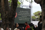
One landscape colour digital photograph taken 22 February 2017 showing brass band members at the Canterbury Earthquake Memorial Service. Behind the band is a digital screen showing words of thanks from survivors.
Digital Photograph: Guests Arriving at the Canterbury Earthquake Memorial …
Images, Canterbury Museum
One landscape colour digital photograph taken 22 February 2017 showing guests being seated prior to the Canterbury Earthquake Memorial Service.
Digital Photograph: First Responders at the Canterbury Earthquake Memorial…
Images, Canterbury Museum
One landscape colour digital photograph taken 22 February 2017 showing first responders at the Canterbury Earthquake Memorial Service.
Digital Photograph: Brass Band at the Canterbury Earthquake Memorial Servi…
Images, Canterbury Museum
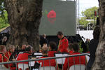
One landscape colour digital photograph taken 22 February 2017 showing brass band members at the Canterbury Earthquake Memorial Service. Behind the band is a digital screen showing an image of flowers floating in the Avon River.
Digital Photograph: Members of the Media at the Canterbury Earthquake Memo…
Images, Canterbury Museum
One landscape colour digital photograph taken 22 February 2017 showing cameramen and journalists at the Canterbury Earthquake Memorial Service.
Digital Photograph: Media Viewing Area at the Canterbury Earthquake Memori…
Images, Canterbury Museum
One landscape colour digital photograph taken 22 February 2017 showing the appointed media viewing area at the Canterbury Earthquake Memorial Service.
Digital Photograph: First Responders and Public Viewing Areas at the Cante…
Images, Canterbury Museum
One landscape colour digital photograph taken 22 February 2017 showing the appointed first responders and public viewing areas at the Canterbury Earthquake Memorial Service.
Digital Photograph: First Responders Laying Wreaths at the Canterbury Eart…
Images, Canterbury Museum
One landscape colour digital photograph taken 22 February 2017 showing first responders laying wreaths at the Canterbury Earthquake Memorial Service.
Digital Photograph: Commemoration Board at the Canterbury Earthquake Memor…
Images, Canterbury Museum
One landscape colour digital photograph taken 22 February 2017 showing a gentleman reading messages on a commemoration board at the Canterbury Earthquake Memorial Service.
Digital Photograph: Flowers Floating in the Avon River
Images, Canterbury Museum
One landscape colour digital photograph taken 22 February 2017 showing flowers floating in the Avon River as part of the Canterbury Earthquake Memorial Service.
Digital Photograph: Sunflower Atop a Road Works Cone
Images, Canterbury Museum
One landscape colour digital photograph taken 22 February 2017 showing a sunflower sitting atop a road works cone as part of the Canterbury Earthquake Memorial Service.
Digital Photograph: Earthquake Memorial Trellis
Images, Canterbury Museum
One landscape colour digital photograph taken 22 February 2017 showing an earthquake memorial trellis at the site of the former Canterbury Television building.
Digital Photograph: Commemorative Note to Andrew Bishop
Images, Canterbury Museum
One landscape colour digital photograph taken 22 February 2017 showing a commemorative note to, and photograph of, Andrew Bishop attached to an earthquake memorial trellis at the site of the former Canterbury Television building.
Digital Photograph: Flowers on an Earthquake Memorial Trellis
Images, Canterbury Museum
One landscape colour digital photograph taken 22 February 2017 showing a bouquet of flowers and a note attached to an earthquake memorial trellis at the site of the former Canterbury Television building.
Digital Photograph: Earthquake Memorial Trellis
Images, Canterbury Museum
One landscape colour digital photograph taken 22 February 2017 showing an earthquake memorial trellis at the site of the former Canterbury Television building.
Digital Photograph: Karen Bishop at an Earthquake Memorial Trellis
Images, Canterbury Museum
One landscape colour digital photograph taken 22 February 2017 showing Karen Bishop attaching a windmill to an earthquake memorial trellis in memory of her son Andrew Bishop at the site of the former Canterbury Television building.
Digital Photograph: Windmill Attached to an Earthquake Memorial Trellis
Images, Canterbury Museum
One landscape colour digital photograph taken 22 February 2017 showing a windmill attached to an earthquake memorial trellis by Karen Bishop in memory of her son Andrew Bishop at the site of the former Canterbury Television building.
Digital Photograph: Flowers at the Site of the Former Canterbury Televisio…
Images, Canterbury Museum
One landscape colour digital photograph taken 22 February 2017 showing a bouquet of flowers left at the site of the former Canterbury Television building by the Toyama Language School in memory of earthquake victims.
Digital Photograph: Flowers at the Site of the Former Canterbury Televisio…
Images, Canterbury Museum
One landscape colour digital photograph taken 22 February 2017 showing bouquets of flowers and gifts left at the site of the former Canterbury Television building in memory of earthquake victims.
Digital Photograph: Flowers at the Site of the Former Canterbury Televisio…
Images, Canterbury Museum
One landscape colour digital photograph taken 22 February 2017 showing a bouquet of flowers left at the site of the former Canterbury Television building by St John New Zealand in memory of earthquake victims and in appreciation of first responders.
The Great Outdoors - Peter Langlands
Audio, Radio New Zealand
Conservationist, forager, angler and former fisheries observer Peter Langlands talks about the many threats to our lakes and waterways. Lynn Freeman asked the Cantabrian how the earthquakes affected Christchurch birds, as there was talk that they left the city.
Recycling: Tim McGurk
Audio, Radio New Zealand
Over the summer on The Weekend we've been talking to recyclers and upcyclers, people who like the Wombles, are making good use of the things that they find, things that the everyday folks leave behind. This is true of Christchurch builder, artist and furniture maker, Tim McGurk. He says he works with whatever junk and materials he can find. Tim crafted several items from the materials salvaged from an earthquake damaged Christchurch house, as part of the Whole House Reuse project. He also made the news when he made a Star Wars inspired X-wing sculpture/lamp out of salvaged rimu.
Sign of the Kiwi re-opens in Christchurch - locals delight
Audio, Radio New Zealand
Built in June 1917, the popular 'Sign of the Kiwi' heritage building in Christchurch's Port Hills has re-opened today after being closed for six years due to earthquake damage.
Phoenix Rising
Audio, Radio New Zealand
The Christchurch earthquakes caused devastating damage to many of the city’s creative spaces. But rising from the rubble has been the Isaac Theatre Royal under the watchful eye of Neil Cox. He’s directed the resurrection of one of the premiere performance spaces in the country.
Earthquake survivor says Wgtn must cordon around unsafe sites
Audio, Radio New Zealand
A woman crushed to within milimetres of her life in the Christchurch earthquake says it is murderously cavalier for Wellington's council not to cordon off weak or prone buildings.
Chch's new super school opens in Aranui with a bumper roll
Audio, Radio New Zealand
Haeata is the first public school in Christchurch to cater for all ages, replacing three eastern suburbs schools that were closed after the earthquakes. RNZ joined more than 900 students for the first day.