
Search
found 417 results
Images for earthquake (February 2011); more images...


Digital Photograph: Earthquake Damage on Norwich Quay, Lyttelton
Images, Canterbury Museum
One landscape colour digital photograph taken on 25 February 2011 showing earthquake damage on Norwich Quay. The photograph is taken from approximately the intersection of Sutton and Norwich Quays looking east along Norwich Quay. The photograph also shows the eastern slope of Lyttelton and the damaged Timeball Station. Norwich Quay’s streetscap...
Book and DVD: Earthquake, Christchurch New Zealand 22 February 2011
Images, Canterbury Museum
One book titled "Earthquake, Christchurch New Zealand 22 February 2011" with text by Chris Moore and Press journalists and images by Press and Fairfax photographers; colour illustrations; published by A Random House New Zealand, Auckland, 2011; accompanying DVD. The sombre tone of this book and DVD reflects the attitudes of the greater Christch...
Digital Photograph: Brass Band at the Canterbury Earthquake Memorial Servi…
Images, Canterbury Museum
One landscape colour digital photograph taken 22 February 2017 showing brass band members at the Canterbury Earthquake Memorial Service. Behind the band is a digital screen showing an image of flowers floating in the Avon River.
Digital Photograph: Windmill Attached to an Earthquake Memorial Trellis
Images, Canterbury Museum
One landscape colour digital photograph taken 22 February 2017 showing a windmill attached to an earthquake memorial trellis by Karen Bishop in memory of her son Andrew Bishop at the site of the former Canterbury Television building.
Digital Photograph: Earthquake damage on corner of Canterbury and London S…
Images, Canterbury Museum
One landscape colour digital photograph taken on 25 February 2011 showing earthquake damage to the premises of Ground Delicatessen on the corner of Canterbury and London Streets. The photograph shows the building's Canterbury Street façade. This building was initially built around 1864 as the Albion Hotel. After many modifications and changes ...
Digital Photograph: Earthquake damage on Canterbury Street, Lyttelton
Images, Canterbury Museum
One landscape colour digital photograph taken on 25 February 2011 showing earthquake damage to houses on the western side of Canterbury Street between London and Winchester Streets. The photograph shows large sections of a brick firewall which have fallen onto the roof of the neighbouring house. The close proximity of buildings in Lyttelton led...
Stretcher: St John 'scoop' stretcher
Images, Canterbury Museum
One silver metal 'scoop' stretcher used by St John staff on 22 February 2011 in emergency first aid response to the Christchurch earthquakes.
Sign: Canterbury Museum Haere Mai, Welcome
Images, Canterbury Museum
One rectangular Canterbury Museum welcome sign displaying the Museum's opening hours. Affixed to the bottom of the sign is a notice demonstrating CERA's approval for the Museum to reopen from 2 September 2011 following the 22 February 2011 earthquake.
Right Rear Car Door: Mazda CX7
Images, Canterbury Museum
One right rear black Mazda CX7 car door damaged during the 22 February 2011 earthquake; white USAR spray paint markings 'P/T // CLE[AR]'. This panel once belonged to a Mazda CX7 car that was crushed by falling rubble during the 22 February 2011 earthquake. Considerably bent out of shape, it demonstrates the potential danger from falling masonry...
Digital Photograph: Earthquake damage to St John's Church, Winchester Stre…
Images, Canterbury Museum
One landscape colour digital photograph taken on 25 February 2011 showing earthquake damage to the Presbyterian Church of St John in Winchester Street Lyttelton. Photograph shows the main doors, roof and collapsed tower at southern end of church. Architect St John's Lyttelton was one of the oldest Presbyterian Churches in Canterbury. The New Ze...
Digital Photograph: Earthquake Damage to Road on Norwich Quay, Lyttelton
Images, Canterbury Museum
One landscape colour digital photograph taken on 25 February 2011 showing earthquake damage to the road, footpath and retaining wall on Norwich Quay. The photograph is taken from below the intersection of Norwich Quay and Canterbury Street looking east along Norwich Quay. Unlike most areas of Christchurch, land damage on the Port Hills was due ...
Digital Photograph: Earthquake damage to the London Street Restaurant on L…
Images, Canterbury Museum
One landscape colour digital photograph taken on 27 April 2011 showing damage to the London Street Restaurant. Photograph taken looking west from the intersection of London Street with Oxford Street and Sumner Road. Adaptability and quick thinking has become a key part of business survival in post earthquake Canterbury. The owner of this bui...
Digital Photograph: Earthquake damage to St John's Church, Winchester Stre…
Images, Canterbury Museum
One landscape colour digital photograph taken on 15 June 2011 showing earthquake damage to the Presbyterian Church of St John in Winchester Street, Lyttelton. Photograph shows the collapsed roof and tower. The photograph is taken from the southeast corner of the church. Architect St John's Lyttelton was one of the oldest Presbyterian Churches in...
Wristband: Bands 4 Hope
Images, Canterbury Museum
One black wristband with the words ‘Band 4 Hope’ machine inscribed. These wristbands were designed as a fundraiser following the 22 February 2011 earthquake. This wristband was left as a tribute at the Canterbury Television (CTV) building which collapsed during the 22 February 2011 earthquake killing 115 people. It is one of three identical bla...
Wristband: Bands 4 Hope
Images, Canterbury Museum
One red wristband with the words ‘Band 4 Hope’ machine inscribed. These wristbands were designed as a fundraiser following the 22 February 2011 earthquake. This wristband was left as a tribute at the Canterbury Television (CTV) building which collapsed during the 22 February 2011 earthquake killing 115 people. It is the only red wristband left ...
Book: Quaky Cat
Images, Canterbury Museum
One blue soft cover children’s book titled 'Quaky Cat' with text by Diana Noonan and colour illustrations by Gavin Bishop. The earthquakes and accompanying aftershocks in Canterbury proved to be a very frightening experience, especially for children. This book was written in response to the 4 September 2010 earthquake to help children understan...
Digital Photograph: Earthquake damage on corner of Canterbury and London S…
Images, Canterbury Museum
One landscape colour digital photograph taken on 25 February 2011 showing earthquake damage to the corner of Canterbury and London Streets. The photograph is taken from Canterbury Street looking down hill. The buildings visible are The Volcano Restaurant, the Lyttelton Library, the Lyttelton Working Mens' Club (The Loons), and the Royal Hotel (o...
Digital Photograph: Earthquake Damage to Lyttelton Coffee Company, London …
Images, Canterbury Museum
One landscape colour digital photograph taken on 9 March 2011 showing earthquake damage to the Lyttelton Coffee Company Building on London Street. The photograph shows a fenced off section of the south side of London Street. Also visible in the photograph are the Lyttelton Four Square, and the gateway leading to the Wunderbar. Due to prior eart...
Digital Photograph: Former Convent of Our Lady of Mercy, Exeter Street, Ly…
Images, Canterbury Museum
One landscape colour digital photograph taken on 12 April 2011 showing earthquake damage to the former Convent of Our Lady of Mercy. St Mary's School, run by the Sisters of Mercy, was also housed in this building. At the time of the 4 September 2010 earthquake the building was a private residence. The sense of loss felt when confronted with the...
Digital Photograph: Earthquake damage to St Joseph's Church, Winchester St…
Images, Canterbury Museum
One portrait colour digital photograph taken on 19 April 2011 showing earthquake damage to the Catholic Church of St Joseph the Worker in Winchester Street Lyttelton. Photograph shows the southern end of church. The fencing erected around the Catholic Church of St Joseph the Worker shows the emphasis which was placed on public safety in the mon...
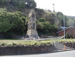
Digital Photograph: Earthquake damage to Lyttelton Cenotaph on Simeon Quay…
Images, Canterbury Museum
One landscape colour digital photograph taken on 12 March 2011 showing earthquake damage to the Lyttelton Cenotaph on Simeon Quay. The unstable top of the memorial has been deconstructed and is visible on the surrounding grass, a plastic tarpaulin has been used to cover the top of the newly exposed stonework and a temporary fence has been erecte...
Picture: Forget-Me-Nots
Images, Canterbury Museum
One picture of forget-me-nots with a message to Saori Kikuda left as an earthquake tribute at the Canterbury Television site and collected on 21 October 2013.
Digital Photograph: Flowers Floating in the Avon River
Images, Canterbury Museum
One landscape colour digital photograph taken 22 February 2017 showing flowers floating in the Avon River as part of the Canterbury Earthquake Memorial Service.
Digital Photograph: Sunflower Atop a Road Works Cone
Images, Canterbury Museum
One landscape colour digital photograph taken 22 February 2017 showing a sunflower sitting atop a road works cone as part of the Canterbury Earthquake Memorial Service.
Artwork: Encode by Jo Nicholls-Parker
Images, Canterbury Museum
One rectangular colour artwork compiled of photographs of Urban Search and Rescue team markings following the Canterbury earthquakes. The artwork is entitled 'Encode' and was created by Mayoress Jo Nicholls-Parker.
Digital Photograph: Earthquake Damage to Lyttelton Historical Museum on Gl…
Images, Canterbury Museum
One landscape colour digital photograph taken on 14 July 2011 showing damage to the Lyttelton Historical Museum on the corner of Gladstone Quay and Donald Street. The photograph shows the safety fencing and containers installed after the 22 February 2011 earthquakes. Architect Closed after the September 2010 earthquakes, the Lyttelton Museum bu...
3-D Model: Port Hills Faults
Images, Canterbury Museum
One oblong perspex covered 3-D model of the fault plains that ruptured to cause the 22 February and 13 June 2011 earthquakes; top of the model also acts as a map overlay. This model provides a visual demonstration of the geological forces that caused the 22 February and 13 June 2011 earthquakes. These forces were so strong that parts of the Por...
Digital Photograph: Commemorative Note to Andrew Bishop
Images, Canterbury Museum
One landscape colour digital photograph taken 22 February 2017 showing a commemorative note to, and photograph of, Andrew Bishop attached to an earthquake memorial trellis at the site of the former Canterbury Television building.