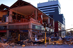
Helicopter Flight over Christchurch
New Zealand

Helicopter Flight over Christchurch
New Zealand

None

An infographic showing planned changes to transport in the central city.

A map showing proposed public transport routes in the central city.

A map showing proposed cycling and walking routes in the central city.

A map showing proposed changes to speed limits on roads in the central city.

None

None

Shows a man representing Christchurch holding aloft the words 'belief', 'optimism' and 'faith' on a plate. Refers to the blueprint for central Christchurch developed by the Christchurch Central Development Unit, which was unveiled on 30 July 2012.
Quantity: 1 digital cartoon(s).

A graphic illustrating quotes from young people about the central city.

The Christchurch Cathedral after loosing its tower and spire after the 6.3 quake hit Christchurch 22 February 2011. This image shows the centre of the city still cordoned off. I took this image on Good Friday, Easter weekend, as the sun rose to shine over the city giving a feeling of hope and resurrection of Christchurch to come in...

A graphic showing proposed central city developments.

A map showing the locations of proposed developments in the central city.

A map showing road closures in the central city.

A map showing areas of the central city where brothels will be allowed.

20131231_8484_EOS M-22 Quake City exhibit
Another city walk around, this time with my brother-in-law from Auckland. Also went to the Quake City exhibition in the city organised by the Canterbury Museum. First fine day for a while.
#4502

A map showing details of the Central City Plan.

A map showing road closures in the central city.

A map showing road closures in the central city.

Another city walk around, this time with my brother-in-law from Auckland. Also went to the Quake City exhibition in the city organised by the Canterbury Museum. First fine day for a while.

A infographic giving the status of large buildings in the central city.

None

Pigeons sit on the remains of one of the tallest buildings in Christchurch that was 95% demolished two or three years ago. The basement (now filled with water) and the columns remain.
Demolished due to damage from the Christchurch 2011 earthquake.

20131231_8503_EOS M-22 From Cashel Street
Another city walk around, this time with my brother-in-law from Auckland. Also went to the Quake City exhibition in the city organised by the Canterbury Museum. First fine day for a while.
#4504

Hit at 4.35am (local time) on Saturday, September 4th 2010, measuring a 7.1 and centered 40km west of the city

Hit at 4.35am (local time) on Saturday, September 4th 2010, measuring a 7.1 and centered 40km west of the city

Hit at 4.35am (local time) on Saturday, September 4th 2010, measuring a 7.1 and centered 40km west of the city

Hit at 4.35am (local time) on Saturday, September 4th 2010, measuring a 7.1 and centered 40km west of the city

Hit at 4.35am (local time) on Saturday, September 4th 2010, measuring a 7.1 and centered 40km west of the city
