
A view down Cashel Street. The Crossing building can be partially seen and the Westpac building is in the background. Taken on a day when a walkway was opened up between Re:Start Mall and Cathedral Square to allow temporary public access.

A view across Cambridge Terrace to the former Canterbury Public Library. Masonry from the building's corners and end gable has fallen onto the footpath below. Wire fencing has been placed around the building as a cordon.

A photograph of holes in the ground on Colombo Street, left by the foundations of a demolished building. A remaining wall of the building previously housing Sergio's Menswear is still standing on the left.

A scanned copy of a double-page spread from an issue of Canta published in April 1971. The pages feature the plans for an extension to the Students' Association building.

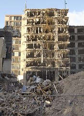
The top story of Fuze Restaurant and Cafe is dismantled by construction workers. The building formerly housed the Harbour Board offices, and was built in 1880.

Photograph captioned by Fairfax, "Kaiapoi businesses and retail outlets are struggling post-earthquake leading into Christmas. The Rooster cafe operating out of a prefab building after their building was demolished".

Detail of the partially-demolished Henry Africa's building. The photographer comments, "A building housing a restaurant and a great little neighbourhood bar is finally coming down because of earthquake damage. Henry's doorway. Still standing - the zebra striped doorway into Henry Africa's".

A photograph of a corrugated-iron clad building on Oxford Street, which is all that remains standing after the buildings around it have been demolished. The photograph is captioned by BeckerFraserPhotos, "13 Oxford Street in Lyttelton".

A crane sits beside the damaged Cranmer Courts building. The stone cladding of a gable end of the building has collapsed, exposing the wooden framework beneath. The photographer comments, "A bike ride around the CBD. Cranmer Courts, Montreal St".

Damage to buildings on the corner of Victoria and Bealey Street with a pile of brick on the side. Two front windows have been spray-painted with the words 'No Go' and the time the building was checked.

A Red Sticker on the window, the heading says 'Do not approach or enter this building'. These placards were used following the September earthquake to inform the public about the status of a building after it had been checked by engineers.

It's five years since the earthquake, and for the first time I feel a sense that the rebuild is taking effect.
In this photo - the left hand building is on the way up, and the right hand building is on the way down.

A photograph of an vacant site on Madras Street where the YWCA used to stand.

A black and white historic photograph of the public viewing the 1931 election results posted on The Press building, taken ca. 1931 by The Press (Christchurch).

A photograph of a window of 268 Madras Street.

A black and white historic photograph of buildings in Cathedral Square, Christchurch, circa 1920s. From left to right: The Weekly Press, H M Customs, Christchurch Tramway Board/Lyttelton Harbour Board.
Being demolished.

Built in the early 1960s for the Lyttelton Road Tunnel, it was severley damaged in the February 2011 earthquake and is not currently used.

None

A lecturer teaches students in the Forestry Building.

A photograph of a damaged building in Lyttelton.

Loose bricks on the corner of a building.

A photograph of damaged buildings along Colombo Street.

A graph showing changes in residential building work.

Damage to a building in the central city.

Photograph captioned by Fairfax, "Blacketts building closed, unsafe".

A photograph of a damaged building in Lyttelton.

A photograph of a damaged building in Lyttelton.

Damage to a building in the Arts Centre.

A photograph of damaged buildings on Colombo Street.