
Band Together - Concert for Canterbury
www.bandtogetherforcanterbury.co.nz
23rd October 2010
Free concrete in Hagley Park following the 4th September 2010 earthquake

An army truck in Avonside after the September 4th earthquake.
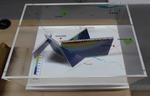
One oblong perspex covered 3-D model of the fault plains associated with the 4 September 2010 Darfield earthquake; top of the model also acts as a map overlay. Geologists continue to study the 4 September 2010 earthquake and consider it is likely to have been a complex event with several faults rupturing simultaneously. This model provides one ...

None

None

None
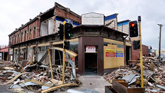
Aftermath of September 4th Earthquake in Canterbury. Shops on Colombo Street in Christchurch - damaged in earthquake and then partially demolished to reduce risk from unstable materials which might otherwise be dislodged in strong winds or subsequent aftershocks. The 1590 aftershocks recorded to date have continued to cause further damage.

NZi3 building reopens after the September earthquakes.

NZi3 building reopens after the September earthquakes.

NZi3 building reopens after the September earthquakes.

NZi3 building reopens after the September earthquakes.

NZi3 building reopens after the September earthquakes.

NZi3 building reopens after the September earthquakes.

NZi3 building reopens after the September earthquakes.

One expandable oblong brown fabric bag produced by Christchurch church group Rechurch; black and green writing on the front and back. Used to deliver lunch to Student Volunteer Army clean up parties after the 4 September 2010 earthquake. This reusable fabric bag from the church group Rechurch, Christchurch was used to deliver lunches to the stu...

One white dust mask with elastic strap to secure around the head. Black printing on the front reads: '3M 8000 / P1 / AS/NZS 1716'. Used by Student Volunteer Army in the clean up after 4 September 2010 earthquake. Face masks were recommended by Christchurch Public Health staff as a safety precaution for those handling liquefaction. Liquefaction ...

One black plastic barrelled wheelbarrow with a blue metal frame, black rubber handles and a pneumatic tyre; manufacturer's name in white on long sides and torn promotional label on short side near handles. Barrel is well used and contains remnants of liquefaction. Used by Student Volunteer Army in the clean up after 4 September 2010 earthquake. ...

Cracks on the road in Avonside after the September 4th earthquake.

Liquefaction in the drains in Avonside after the September 4th earthquake.

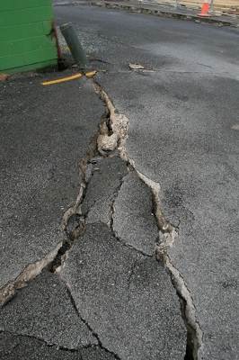
Cracks across the road in Avonside after the September 4th earthquake.
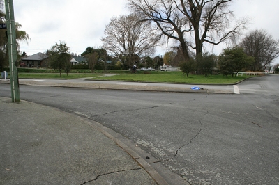
Cracks across the road in Avonside after the September 4th earthquake.
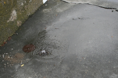
Water surging out of a drain after the September 4th earthquake.

A lopsided powerline pole in Avonside after the September 4th earthquake.

Cracks along the ground in Kaiapoi, after the September 4th earthquake.
Cracks in a road in Kaiapoi, after the September 4th earthquake.

One metal hanging light fixture with three globes. Frame features a stylized plants motif. The globes feature green, brown and white glass petals welded into a globe shape. Owner of Hadleigh House 1904-1921

One landscape colour digital photograph taken on 26 May 2013 showing the southern cliffs of Godley Head. Taken from the middle of the shipping channel. Some earthquake damage to the cliffs is visible. There were several major rock falls along the coastal cliffs near Christchurch and Lyttelton Harbour. At Godley Head these caused damage to the W...

One landscape colour digital photograph taken on 15 June 2011 showing earthquake damage to the Anglican Church of The Most Holy Trinity in Winchester Street, Lyttelton. Photograph shows collapsed roof of the nave and north transept. Photograph taken from the north side of the church. Architect The collapse of the Church of the Most Holy Trinity ...
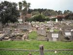
One landscape colour digital photograph taken on 30 June 2011 showing earthquake damage to graves in Lyttelton Roman Catholic and Dissenters (Public) Cemeteries in Reserve Terrace. Most of the headstones and grave surrounds in the photograph show damage. Looking east in the Dissenters (Public) section of the cemetery. The Lyttelton cemeteries a...

One landscape colour digital photograph taken on 30 June 2011 showing earthquake damage to a section of retaining wall in Sumner Road. Plastic sheeting installed to stabilise previous damage and protect from water erosion is visible to the right of the photograph. Also visible in the photograph is a boarded up broken window and temporary safety ...