
Photograph captioned by BeckerFraserPhotos, "This loop of the Avon encircles Horseshoe Lake and gives the area its name and its attraction as a place to live. The land close to the Avon River has severe issues with slumping, lateral movement and liquefaction, so that much of it is red zoned and the houses will be demolished".

A large sign outside QEII stadium advertising a IPC Athletics World Championships event 21-30 January 2011. The photographer comments, "A Sunday afternoon ride to New Brighton, then back via Aranui, Wainoni, Dallington, and Richmond. Not a cheerful experience. QE2 sign. This must have still been in place on Feb 22, 2011. It advertises an athletics meet three weeks earlier".

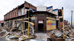
One landscape colour digital photograph taken on 15 April 2011 showing the demolition of the Volcano Restaurant, the Lava Bar, Lyttelton Fisheries and Coastal Living Design Store on the corner of London and Canterbury Streets. In Christchurch's Central Business District many of the high profile demolitions took place out of public view in the ...
One landscape colour digital photograph taken on 15 April 2011 showing the demolition of Coastal Living Design Store on London Street. In Christchurch's Central Business District many of the high profile demolitions took place out of public view in the Red Zone. By contrast, the demolitions on London Street after the 22 February 2011 earthquake...

Friday 22 February 2013.
Official Supported Site for River of Flowers: Horseshoe Lake
Riverbank on Lake Terrace Road, opposite the bus stop between Oregon and Tangmere Places
Hosted by: Burwood Primary School and Community.
File reference:
CCL-2013-02-22-River-of-FlowersDSC_03401.JPG
From the collection of Christchurch City Libraries.
...

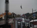
The old New Brighton Power Boat Club building was badly damaged in the February 2011 earthquake, and is only now (July 2012) being demolished.
The building is just down the road from where I grew up and is a New Brighton iconic building.

The old New Brighton Power Boat Club building was badly damaged in the February 2011 earthquake, and is only now (July 2012) being demolished.
The building is just down the road from where I grew up and is a New Brighton iconic building.

one of Christchurch's abandoned suburbs. The land moved - bricks and block walls everywhere collapsed - two multi story buildings folded - 184 people died.
Wooden framed houses largely stayed up, many concrete slabs cracked, power poles leaned in liquid ground, surface bubbled, services ruptured .... damage to the cbd still gets the most cover...

Taken one week after the 6.3 magnitude quake hit Christchurch 22 February 2011. Processed in HDR.
We stood near here during the 2 minute silence observed by all New Zealanders.

Revisiting some of my images coming up to our one year anniversary of the 22 February 2011 Christchurch 6.3 earthquake.

Taken several days after the 6.3 magnatude quake hit Christchurch 22 February 2011. Processed in HDR to capture some of the "feeling" when thinking about the loss of lives when the quake hit.

A view after the 7.1 magnitude earthquake in Christchurch 4 September 2010.
Corner of Colombo and Byron Streets.
Given a bit of a HDR process to add some of what I was "feeling" at the time.

Taken soon after the 6.3 magnatude quake hit Christchurch 22 February 2011. Done in HDR to capture some of the "feeling" of what I felt.

Telegraph Road was a straight road before the recent 7.1 magnitude earthquake. The fault ran right through here and now the road has a dramatic kink in it.
Aftermath of September 4th Earthquake in Canterbury. Shops on Colombo Street in Christchurch - damaged in earthquake and then partially demolished to reduce risk from unstable materials which might otherwise be dislodged in strong winds or subsequent aftershocks. The 1590 aftershocks recorded to date have continued to cause further damage.

Taken one week after the 6.3 magnatude quake hit Christchurch 22 February 2011. Processed in HDR. Great to see the clean up already - lifts our spirits!.

Taken soon after the 6.3 magnatude quake hit Christchurch 22 February 2011. Done in HDR to capture some of the "feeling" of what I felt.

Laura Young and I tying down tarps over the hole in the roof. We did what we could to tie it down with tension and weigh it down with bricks tied to the tarps. Why? Because gale-force winds are predicted for tomorrow (Sunday) and rain on Tuesday.

Taken soon after the 6.3 magnatude quake hit Christchurch 22 February 2011. Done in HDR to capture some of the "feeling" of what I felt.

The September Canterbury earthquake. These pictures were taken of Colombo Street in Sydenham. A lot of masonry in this area has been damaged/fallen down.
The New Zealand Army, along with Police, were minding the cordons.
Note: these photos were taken on a cellphone; mind the quality.

The September Canterbury earthquake. These pictures were taken of Colombo Street in Sydenham. A lot of masonry in this area has been damaged/fallen down.
The New Zealand Army, along with Police, were minding the cordons.
Note: these photos were taken on a cellphone; mind the quality.

The September Canterbury earthquake. These pictures were taken of Colombo Street in Sydenham. A lot of masonry in this area has been damaged/fallen down.
The New Zealand Army, along with Police, were minding the cordons.
Note: these photos were taken on a cellphone; mind the quality.

The September Canterbury earthquake. These pictures were taken of The New Zealand Army, along with Police, minding the cordons. This was beside The Press building, and behind the Christchurch Cathedral.
Note: these photos were taken on a cellphone; mind the quality.

The September Canterbury earthquake. These pictures were taken of Colombo Street in Sydenham. A lot of masonry in this area has been damaged/fallen down.
The New Zealand Army, along with Police, were minding the cordons.
Note: these photos were taken on a cellphone; mind the quality.

A view after the 7.1 magnitude earthquake in Christchurch 04 September 2010.
Victoria Street. So sad to see history die - both buildings and business.
Given a bit of a HDR process to add some of what I was "feeling" at the time.
Victoria Apartments demolition is under way on a walk around the city to find out what is happening in the city. Feb 17, 2014 Christchurch New Zealand.
"soft-stripped", which means that any remaining belongings will be removed, as well as furnishings and internal walls.

Working at getting things out of the Victoria Square before it is demolished.
www.stuff.co.nz/the-press/news/christchurch-earthquake-20...
What I found on my walk around the city January 15, 2014 Ch...

After my visit at the hospital for physiotherapy on my hand I took a walk around the city on my way home.
Demolition of the Victoria Square apartments February 12, 2014 Christchurch New Zealand.
www.s...
What I found on a walk around the city Christchurch November 20, 2013 New Zealand.
www.isaactheatreroyal.co.nz/
en.wikipedia.org/wiki/2011_Christchurch_earthquake

A photograph submitted by Scott Thomas to the QuakeStories website. The description reads, "The picture is of St Martins, a suburb just 2 minutes drive up the street from my place. The photo does not do it justice but this road was like the moon, it used to be flat and it is wet due to burst pipes. Photo taken shortly after the 22 Feb 2011 earthquake".