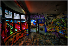
Christchurch's Graffiti House...
This Cranford Street house was damaged in the earthquakes and is due for demolished this week but has been given a Graffiti Makeover by local Street Artists.

A photograph looking east down Hereford Street from the intersection with Manchester Street. In the distance, an excavator can be seen filling a truck with the rubble from a demolished building.

A photograph looking south-east across Lichfield Street from near the intersection with Colombo Street. Many of the buildings on Lichfield Street have been demolished, with others patched up with plywood.

A crane driving piles in for the foundations of the new New World supermarket in Kaiapoi. The old New World was demolished after being damaged in the 4 September 2010 earthquake.

A photograph submitted by Raymond Morris to the QuakeStories website. The description reads, "St. Elmo courts was situated on the corner of Hereford St. and Montreal St. Since demolished after the 2010-2011 earthquakes.".

A photograph submitted by Raymond Morris to the QuakeStories website. The description reads, "Domo store (McKenzie and Willis) 236 Tuam St. is one of many paintings completed by artist Raymond Morris of earthquake demolished buildings.".

The damaged Sumner Surf Lifesaving Club building. The rear of the building has been demolished, and spray-painted notices on the walls read "No entry, not safe" and "No parking, not safe".

Double Dipper', a Gap Golf course on a the site of a demolished building. It has been built by Gap Filler out of planks of wood, stones, bricks and green felt.

The soon-to-be demolished ANZ building in Cathedral Square. A walkway from Gloucester Street to the Square was opened up for a few days to allow the public a closer look at the Cathedral.

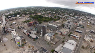
A snapshot from GPS Boomerang's SmartBird flight over the Christchurch red zone on 23 December 2012, looking over Cathedral Square with the Cathedral and the Post Office visible. The BNZ Building has been partially demolished.
A snapshot from GPS Boomerang's SmartBird flight over the Christchurch red zone on 23 December 2012, looking over Bedford Row with Latimer Square in the distance to the left. The Newstalk ZB Building has been demolished.

The stitching of felt hearts on the anniversary of the first earthquake on the site of the demolished Ground Culinary Centre, which is now the Lyttelton Petanque Club grounds, a gathering spot for many community events and activities.

View of the corner of Montreal and Victoria Street. In the background is a vacant lot left by buildings that has been demolished, and on the right is Gordon Smith & Sons fruit and vegetable shop.

Two excavators and building rubble in front of the Terrace on the Park apartment complex. Two buildings in the complex required urgent demolition, and the other buildings in the complex will eventually be demolished.

Two excavators and building rubble in front of the Terrace on the Park apartment complex. Two buildings in the complex required urgent demolition, and the other buildings in the complex will eventually be demolished.

A crane driving piles in for the foundations of the new New World supermarket in Kaiapoi. The old New World was demolished after being damaged in the 4 September 2010 earthquake.

A hording erected on an empty section where a building was demolished advertises an office development to be built there. "Modern design built to code" is one of the key features advertised.

The site of a demolished building on Hereford Street, with a crane and two skips. Piles of rubble can be seen to the left. The site has been cordoned off with wire fencing.

A demolition site on Welles Street, where the interior structures have been removed. View into the building site through the partial demolished exterior wall. A crane and demolition workers can be seen on site.

A demolition site on Welles Street, where the interior structures have been removed. View into the building site through the partial demolished exterior wall. A crane and demolition workers can be seen on site.

A demolition site on Welles Street, where the interior structures have been removed. View into the building site through the partial demolished exterior wall. A crane and demolition workers can be seen on site.
A demolition site with the words "No Go" spray painted on a fence that has been mostly demolished. Demolition rubble is still contained within the grounds. A portaloo can be seen on the footpath.

Now empty and soon to be demolished - sadly for the family and all the customers. Fortunately all plant and stock saved and the search to go on for another suitable space

A photograph of Doug Sexton's garden at 378 Oxford Terrace, now overgrown. In the background is his partially-demolished garage. The photographer comments, "Sexton's garden was once published in Small Gardens".

Photograph captioned by Fairfax, "Major earthquake hits Christchurch. The Valley Inn in Heathcote gets demolished. Local Kerry McCarthy sits with daughter Maeve (4) and watches the pub get knocked down".

A photograph of the former site of a house at 466 Oxford Terrace. The house was demolished after the land was zoned Red. Grass has begun to grow on the site.

A photograph of an excavator demolishing the Art Gallery Apartments Building on Gloucester Street. To the left, a truck has been parked on the site in order to collect the rubble.

A photograph looking north along the footpath of Bangor Street. To the right there are the former sites of several houses. The houses were demolished after the land was zoned Red.

Photograph captioned by BeckerFraserPhotos, "207-211 Manchester Street demolished. The man on the roof (centre, slightly right) is throwing bricks off the collapsed roof of the old church hall".

This block of shops on Victoria Street was so badly damaged that it had to be demolished following the magnitude 7.1 earthquake that struck Christchurch on Saturday 4 September 2010.