
A photograph of a volunteer from Wellington Regional Emergency Management placing items in the back of a van. The van has a small kitchen in the back.

Photograph captioned by Fairfax, "Cassia Place brothers Daniel and Josh Evans walk armed with a shovel to borrow fuel, after waking up to find their garden under silt".

A photograph captioned by BeckerFraserPhotos, "A residential property on the corner of Liggins Street and Jean Batten Place in the Horseshoe Lake district".

A photograph captioned by BeckerFraserPhotos, "A residential property on the corner of Jean Batten Place and Liggins Street in the Horseshoe Lake district".

A photograph looking north up Colombo Street from near the intersection with Tuam Street. Building rubble litters the left side of the road, as well as the right in some places in the distance.

An aerial photograph of the Horseshoe Lake area, with Queensbury Street in the centre.

A photograph captioned by BeckerFraserPhotos, "A residential property on the corner of Liggins Street and Jean Batten Place in the Horseshoe Lake district".

A photograph captioned by BeckerFraserPhotos, "A residential property on the corner of Jean Batten Place and Liggins Street in the Horseshoe Lake district".

A photograph of the earthquake damage to the curb of a street in Christchurch. The curb has cracked in two places and slumped, exposing the earth beneath the grass turf.

A photograph captioned by BeckerFraserPhotos, "A residential property on the corner of Liggins Street and Jean Batten Place in the Horseshoe Lake district".

Cracking along the pavement at Halswell Primary School. The ground has risen and fallen in places leaving an uneven surface where the children usually play.

A photograph captioned by BeckerFraserPhotos, "A residential property on the corner of Liggins Street and Jean Batten Place in the Horseshoe Lake district".
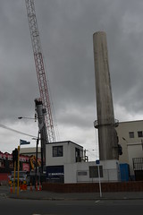
Christchurch Hospital Chimney.
File reference:
CCL-2012-02-20-CanterburyBrewery-February-2012 DSC_148.JPG
From the collection of Christchurch City Libraries.

Canterbury Brewery, St Asaph Street, Christchurch.
File reference:
CCL-2012-02-20-CanterburyBrewery-February-2012 DSC_144.JPG
From the collection of Christchurch City Libraries.

Canterbury Brewery, St Asaph Street, Christchurch.
File reference:
CCL-2012-02-20-CanterburyBrewery-February-2012 DSC_147.JPG
From the collection of Christchurch City Libraries.

Canterbury Brewery, St Asaph Street, Christchurch.
File reference:
CCL-2012-02-20-CanterburyBrewery-February-2012 DSC_142.JPG
From the collection of Christchurch City Libraries.

Canterbury Brewery, St Asaph Street, Christchurch.
File reference:
CCL-2012-02-20-CanterburyBrewery-February-2012 DSC_146.JPG
From the collection of Christchurch City Libraries.

Manchester Street near the corner of Gloucester Street.

Hit at 4.35am (local time) on Saturday, September 4th 2010, measuring a 7.1 and centered 40km west of the city

Canterbury Provincial Council and Supreme Court Buildings, Durham Street North.

Montreal Street and Armagh Street, Cranmer Square.

Canterbury Provincial Council and Supreme Court Buildings, Durham Street North.

Colombo Street looking south towards Cathedral Square, taken from Armagh Street.

Montreal Street and Armagh Street, Cranmer Square.

Montreal Street and Armagh Street, Cranmer Square.

Christchurch Cathedral, photo taken from the Warners Novotel, Cathedral Square.

Montreal Street and Armagh Street, Cranmer Square.

St Elmo Courts corner of Montreal & Hereford Streets

PWS-2010-12-09-05560

Gloucester Street looking west, near the corner of Manchester Street.