
A map showing the locations of tall buildings to be demolished.

A map showing Green, Orange, Red, and White Zones in Kaiapoi.

A map showing newly Green-Zoned properties in the Port Hills.

An map showing an area where sewers have been declared useable.

A map showing the site of the new central police station.

A map showing streets with a 30 km/h speed limit.

A map showing the route of the Red Zone bus tour.

A map showing the location of streams under the central city.

A map showing the location of a proposed subdivision in Kaiapoi.

A map showing the locations of damaged heritage homesteads in Canterbury.

A map showing the locations of arsons in the eastern suburbs.

A map of Canterbury Earthquake Recovery Authority residential zones in Christchurch.

A photograph of the front cover of a folded AWA Trails map. In the background are posters from phase 2 of the All Right? campaign. The photograph was taken at the launch of the AWA Trails. All Right? posted the photograph on their Facebook page on 23 September 2015 at 9:09am. The Facebook image is captioned, "To download a free map visit www.AllRight.org.nz/AWA today!".

A photograph of a map used by emergency management personnel to inspect buildings after the 22 February 2011 earthquake. The map is of the block bordered by Barbadoes Street, Worcester Street, Gloucester Street, and Fitzgerald Avenue. Many of the buildings have been highlighted in blue, with some smaller buildings highlighted in orange. Numbers and messages have been written on the map with biro.

A map showing the location of heritage buildings in the residential red zone.

A map showing the locations of proposed developments in the central city.
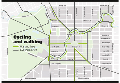
A map showing proposed cycling and walking routes in the central city.

A map showing the location of major building consents issued in Christchurch.

A map showing proposed alcohol ban zones in Riccarton, Merivale, and Papanui.

A map comparing changes in property values in Christchurch and surrounding areas.

A map showing likely residential land availability in the Eastern Waimakariri district.

A map showing the location of red-stickered buildings in the CBD.

A graphic promoting an interactive map of subdivisions on press.co.nz.

A map showing the precincts proposed in the Christchurch Central Recovery Plan.

A map showing the proposed location of the central city retail precinct.

An incomplete map showing the location of schools relative to new subdivisions.

A map showing the gathering point for a protest against the council.

A map showing changes in property values in Christchurch and surrounding areas.

A map showing the epicentres of the 4 September earthquake and aftershocks.

A map showing the epicentres of aftershocks over a 36-hour period.