
185 pieces of Rock from Halswell Quarry to represent the 185 lives lost as a result of the 22/02/11 earthquake.

Following the 5.8 and 6.0 quakes of 23/12/11 there is further damage to the track separating the Bexley Wetlands from the Pacific Park housing area.

Houses teeter over the edge above Redcliffs School.

20120131_8174_1D3-400 Eathquake damage
Houses above Main Road, Sumner.
#2153

Damaged houses above Shag Rock.

20120805_7586_1D3-600 30 seconds later the dust drifts across the city.
Following the demolition of the earthquake damaged Newstalk ZB building.
#2649

Following the 5.8 and 6.0 quakes of 23/12/11 there is further damage to the track separating the Bexley Wetlands from the Pacific Park housing area.

20100905_3336_1D3-24 Ground movement Pacific Park - Christchurch earthquake
A house in Pacific Park (Bexley) that borders the Bexley Wetlands. Land moved towards the wetlands and the closer to wetlands the more severe the damage.
#382
Went for a drive down to South New Brighton/Southshore after work today to see what interesting birds I could find on the Estuary (godwits, skuas, terns etc), but passing Jellico Street, I saw this. T-Rex the seismic survey truck from the University of Texas that is visiting the city (first time out of USA). Weighs 30 tonne and from the marks o...

Went for a drive down to South New Brighton/Southshore after work today to see what interesting birds I could find on the Estuary (godwits, skuas, terns etc), but passing Jellico Street, I saw this. T-Rex the seismic survey truck from the University of Texas that is visiting the city (first time out of USA). Weighs 30 tonne and from the marks o...

Went for a drive down to South New Brighton/Southshore after work today to see what interesting birds I could find on the Estuary (godwits, skuas, terns etc), but passing Jellico Street, I saw this. T-Rex the seismic survey truck from the University of Texas that is visiting the city (first time out of USA). Weighs 30 tonne and from the marks o...

Awaiting the demolition ball! See the hole punched in by the neighbouring building (now demolished) during the February 22 2011 earthquake. This building is leaning to the north (left) while it's now demolished neighbour was leaning to the south (right).
All because the crap land gave way underneath!

Part of a house that fell can be seen on the rocks above right hand containers.

This is the Summit Road below Mt Cavendish and shows a few remaining high buildings in the central city beyond (in setting sun). Just above centre is the doomed AMI Stadium (1) aka Lancaster Park, home to Canterbury cricket and rugby till the erathquakes.

Exactly 2½ years (27/02/11 - 27/08/13) since the Queensland (Australia) SAR team TF1 spray painted this on a concrete fence in Armagh Street. Not many of these signs left now as many buildings have been demolished.

20130312_4425_1D3-150 South New Brighton boardwalk track [Explored]
Damaged in the earthquakes, now with more bends and not level as it was before.
Selected for Explore. #306 12/05/13
#3402
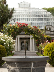
Cunningham House at the Christchurch Botanic Gardens is still closed due to earthquake damage. I wonder if it will ever re-open or suffer the demolition fate many other iconic structures in Christchurch have.

Part of the container wall to stop rock falls on Main Road, Sumner.
The jetty in the South New Brighton Domain was rebuilt a few years ago. It was straight and level till the earthquakes. Has been closed for 2½ years now.

20100905_3347_1D3-32 Bridge Street split depth - Christchurch earthquake
The city side of the South Brighton bridge. Approaches on both sides will need extensive work before this bridge can re-open.
Bridge opened for traffic less than a week later, but still (23/09) has 30kmh speed restriction.
#378

Pigeons sit on the remains of one of the tallest buildings in Christchurch that was 95% demolished two or three years ago. The basement (now filled with water) and the columns remain.
Demolished due to damage from the Christchurch 2011 earthquake.

20161211_0216_1D3-24 Six years on
A view that was impossible six years ago. There was a group of buildings including another high-rise in the vacant area in the middle ground.
#7986

What more can one say except that Shag Rock is now about one third it's original height. Whitewash Head in the background with the road that now drops over a cliff.

Nearly 80 40 foot containers (most two high) protect Wakefield Avenue in Sumner from further rock falls. Behind these (to the left) are houses, church, bowling club, RSA (Returned Servicemens Association) and other community buildings that have been isolated now for nearly two years now. On the right upper third boundary (just behind two stand a...

The small wharf area of the now gone Pleasant Point Yacht Club has already been taken over by the Pied Shags (cormorants).
It is under water now except for low tide. Note the dead pine tree in background. Many have died because of the salt water their roots are in.

20111230_7222_1D3-70 New Brighton
Further damage to the bank following the two quakes on 23/12/11. The sewer line broke here and was repaired (patched) by council staff on Christmas Eve. It is hard to beleve that this rock wall was level with the land here, before any of the quakes.
#2004

The jetty in the South New Brighton Domain was rebuilt a few years ago. It was straight and level till the earthquakes. Has been closed for 2½ years now. The shags like it though!

Shot from up Hunstbury Hill with a 600mm f/4 on a very grey morning. 8am demolition. The guy behind me only looked up when the sounds of the explosion reahed us and the building was half way down!

20100904_3309_1D3-24 Christchurch earthquake
Wairoa Street
Another web site used this image (with a link to this Flickr page), so the view count sky rocketed.
CERA (Canterbury Earthquake Recovery Authority)/Tonkin & Taylor also used this image on page 13 of a Land Damage presentation on 23/06/11. This was also released as a PDF. A few mo...

20100913_3424_1D3-400 Castle Rock
The damage to Castle Rock, overlooking the Heathcote Valley from the 7.1 earthquake on September 4th.
#385