Search
found 19737 results
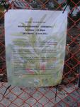
Digital Photograph: Sign Advertising Whakahorohoro Ceremony in Lyttelton
Images, Canterbury Museum
One portrait colour digital photograph taken on 8 June 2011 of a sign advertising a Whakahorohoro Ceremony in Lyttelton. The sign is a printed piece of paper which has been laminated and attached to the fence on the site of Ground Delicatessen on the corner of London and Canterbury Streets. The cleared site is visible through the fence in the ba...

Digital Photograph: Lyttelton Main School from the Gaol Steps, Lyttelton
Images, Canterbury Museum
One landscape colour digital photograph taken on 13 May 2011 showing Lyttelton Main School viewed from above near the top of the Gaol Steps between Oxford and St Davids Streets. The photograph is taken at an angle. Several subsequently demolished buildings are visible beyond the school including (from left to right) Lyttelton Police Station, th...

Digital Photograph: Former Convent of Our Lady of Mercy, Exeter Street, Ly…
Images, Canterbury Museum
One landscape colour digital photograph taken on 12 April 2011 showing earthquake damage to the former Convent of Our Lady of Mercy. St Mary's School, run by the Sisters of Mercy, was also housed in this building. At the time of the 4 September 2010 earthquake the building was a private residence. The sense of loss felt when confronted with the...

Digital Photograph: Gaol Steps and Lyttelton Main School, Oxford Street, L…
Images, Canterbury Museum
One landscape colour digital photograph taken on 13 May 2011 showing the damage to the Gaol Steps between Oxford and St Davids Streets and the upper playground of Lyttelton Main School. The Gaol Steps are a pedestrian link between Oxford and St Davids Streets. In October 2013 these steps were closed and barricaded with temporary fencing because...

Digital Photograph: Earthquake damage to St Joseph's Church, Winchester St…
Images, Canterbury Museum
One portrait colour digital photograph taken on 19 April 2011 showing earthquake damage to the Catholic Church of St Joseph the Worker in Winchester Street Lyttelton. Photograph shows the southern end of church. The fencing erected around the Catholic Church of St Joseph the Worker shows the emphasis which was placed on public safety in the mon...

Digital Photograph: The site of the Harbourlight Theatre, London Street, L…
Images, Canterbury Museum
One landscape colour digital photograph taken on 8 June 2011 showing the site of the Harbourlight Theatre on London Street. The site is fenced off, on the fence is the same heart shape which appears tied to a fence in a different part of London Street in 2013.17.39 A white painted wooden cross has been placed in the ground with 24 [street numbe...

Digital Photograph: Earthquake damage to Lyttelton Cenotaph on Simeon Quay…
Images, Canterbury Museum
One landscape colour digital photograph taken on 12 March 2011 showing earthquake damage to the Lyttelton Cenotaph on Simeon Quay. The unstable top of the memorial has been deconstructed and is visible on the surrounding grass, a plastic tarpaulin has been used to cover the top of the newly exposed stonework and a temporary fence has been erecte...

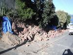
Digital Photograph: Temporary Repairs to Retaining Wall in Ripon Street, L…
Images, Canterbury Museum
One landscape colour digital photograph taken on 14 July 2011 showing the temporary repairs made to the retaining wall in the middle of Ripon Street. The temporary wall replaces two sections of red stone wall which collapsed in the June 2011 Earthquake. It is made from stacked concrete cubes with coarse fill and the top is covered with black pla...

Digital Photograph: Demolition of the former Library, Council Chambers and…
Images, Canterbury Museum
One landscape colour digital photograph taken on 11 June 2011 showing the demolition of the old Lyttelton Library, Council Chambers and Magistrates' Court on the corner of Oxford Street and Sumner Road. The photograph shows the upper floor of the building being demolished with a high reach digger. At the time of the 22 February 2011 Earthquake...

Digital Photograph: Departure of Her Majesty's New Zealand Ship Canterbury…
Images, Canterbury Museum
One landscape colour digital photograph taken on 7 March 2011 showing Her Majesty's New Zealand Ship (HMNZS) Canterbury departing Lyttelton following the completion of her support role in Canterbury following the 22 February 2011 Earthquake. The photograph shows HMNZS Canterbury passing through the Moles out of the Inner Harbour and turning to ...

Digital Photograph: Demolition of Former Canterbury Hotel, corner of Norwi…
Images, Canterbury Museum
One landscape colour digital photograph taken on 14 July 2011 showing the demolition of the former Canterbury Hotel on the corner of Norwich Quay and Oxford Street. At the time of demolition the ground floor was occupied by the Magma Gallery. Also visible in the photograph are the Old Post Office, Lyttelton Takeaways (corrugated iron walls) and ...

Digital Photograph: Partial demolition of the Old Lyttelton Harbour Board …
Images, Canterbury Museum
One landscape colour digital photograph taken on 19 May 2011 showing the partial demolition of the old Lyttelton Harbour Board Offices on the corner of Oxford Street and Norwich Quay. The photograph shows the upper floor of the original part of the building being removed and a temporary roof being constructed over the ground floor. At the time o...
Digital Photograph: Earthquake Damage to Retaining Wall, corner of Oxford …
Images, Canterbury Museum
One landscape colour digital photograph taken on 15 June 2011 showing earthquake damage to the retaining wall on the northeast corner of Oxford and Exeter Streets. The wall was constructed from unreinforced blocks of local red volcanic rock held together with mortar. Retaining walls in Lyttelton were built of unreinforced soft volcanic stone in...

Digital Photograph: Demolition of the former Library, Council Chambers and…
Images, Canterbury Museum
One landscape colour digital photograph taken on 11 June 2011 showing the demolition of the old Lyttelton Library, Council Chambers and Magistrates' Court on the corner of Oxford Street and Sumner Road. The photograph shows the upper floor of the building being demolished with a high reach digger and a jet of water being played on the building ...

Digital Photograph: Demolition of Former Canterbury Hotel, corner of Norwi…
Images, Canterbury Museum
One landscape colour digital photograph taken on 14 July 2011 showing the demolition of the former Canterbury Hotel on the corner of Norwich Quay and Oxford Street. At the time of demolition the ground floor was occupied by the Magma Gallery. Also visible in the photograph are 'Tin Palace' and a former office building which shows repairs made by...

Digital Photograph: Earthquake Damage to Canterbury Hotel and shops. Oxfor…
Images, Canterbury Museum
One landscape colour digital photograph taken on 15 June 2011 showing earthquake damage to the former Canterbury Hotel and adjoining row of shops on Oxford Street. This photograph was taken on Oxford Street and shows the collapsed façade of the row of shops behind safety fencing, the interior of the building is exposed. Shadbolt House is visib...

Digital Photograph: Temporary Theatre, London Street, Lyttelton
Images, Canterbury Museum
One landscape colour digital photograph taken on 6 September 2011 showing the temporary theatre erected on the site of the Volcano Café on London Street for a production of Macbeth by The Loons Circus Theatre Company. The green canopy supported on shipping containers was used to shelter the audience. The stage area was the demolition site partia...

Digital Photograph: Partial Demolition of the Old Lyttelton Harbour Board …
Images, Canterbury Museum
One landscape colour digital photograph taken on 16 June 2011 showing the partial demolition of the old Lyttelton Harbour Board Offices on the corner of Oxford Street and Norwich Quay. The photograph shows the temporary roof being constructed over the original ground floor of the building. At the time of the 22 February 2011 earthquake the build...

Digital Photograph: Earthquake Damage to Canterbury Hotel and shops. Oxfor…
Images, Canterbury Museum
One landscape colour digital photograph taken on 15 June 2011 showing earthquake damage to the former Canterbury Hotel and adjoining row of shops on Oxford Street. This photograph was taken on Oxford Street and shows the collapsed façade of the row of shops behind safety fencing, the interior of the building is exposed. The design of many older...

Digital Photograph: Earthquake damage to St John's Church, Winchester Stre…
Images, Canterbury Museum
One landscape colour digital photograph taken on 15 June 2011 showing earthquake damage to the Presbyterian Church of St John in Winchester Street, Lyttelton. Photograph shows the collapsed roof and tower. The photograph is taken from the southeast corner of the church. Architect St John's Lyttelton was one of the oldest Presbyterian Churches in...
Evans, Malcolm Paul, 1945-: "Worried about holidaying in New Zealand - wel…
Images, Alexander Turnbull Library
A couple sits in a Travel Agency discussing places to go for a holiday. The travel agent says 'Worried about holidaying in New Zealand - well how about...' and she turns to the display of countries to visit on the wall behind her. Each of the countries is illustrated with a very negative image; e.g. 'Japan' with a nuclear symbol, 'Thailand' with a pile of human ashes, 'Sth Africa' with two arms raised in desperate supplication... Context - The couple do not want to visit New Zealand because of the Canterbury earthquakes and there seem to be an awful lot of natural disasters or wars or high expense etc. recently. Colour and black and white versions available Quantity: 2 digital cartoon(s).

La Boheme Restaurant
Images, eqnz.chch.2010
This restaurant used to do bookings for large groups only and you all had to pick and wear funny hats from hooks around the walls.

Monumental Masons collapsed roof
Images, eqnz.chch.2010
The side wall of the building on the left collapsed onto their roof, collapsing it into the stonemasons store. Several gravestones were also damaged!

St Pauls Church - other end of building subsided by about 50 cm
Images, eqnz.chch.2010
The base of the tower on the right of this picture has sunk about 25cm so that the lower course of bricks have disappeared below ground level. Meanwhile the other end of the building has sunk about 50cm splitting the building into thirds. The sand you can see is what came bubbling up out of the ground due to liquifaction. Unfortunately the build...

Sydenham Churchills Tavern - the black canopy under all those bricks is wh…
Images, eqnz.chch.2010
Reasons why it pays not to be a smoker - if the quake had hit during opening hours there would have been probably half a dozen smokers underneath the black awning crushed by falling bricks.

St Pauls school playground adjacent to church - that is not a wall at the …
Images, eqnz.chch.2010
The line that runs across this picture is the subsidence line - everything this side of the line has sunk by about 50 cm.

St Pauls Church - tower has subsided about 25cm
Images, eqnz.chch.2010
The base of the tower on the right of this picture has sunk about 25cm so that the lower course of bricks have disappeared below ground level. Meanwhile the other end of the building has sunk about 50cm splitting the building into thirds. The sand you can see is what came bubbling up out of the ground due to liquifaction. Unfortunately the build...

St Pauls church tower subsidence - first course of bricks no longer visible
Images, eqnz.chch.2010
The base of the tower on the right of this picture has sunk so that the lower course of bricks have disappeared below ground level. The sand you can see is what came bubbling up out of the ground due to liquifaction.

View from the back of the room
Images, eqnz.chch.2010
If you look very closely, running from the nearest right desk to the second desk on the left hand side, you can see my 'fault-line', - the crack that runs the length of the classroom under the lino.

St Pauls Church on Gayhurst Road Dallington
Images, eqnz.chch.2010
The base of the tower on the right of this picture has sunk about 25cm so that the lower course of bricks have disappeared below ground level. Meanwhile the other end of the building has sunk about 50cm splitting the building into thirds. The sand you can see is what came bubbling up out of the ground due to liquifaction. Unfortunately the build...