
One landscape colour digital photograph taken on 25 February 2011 showing earthquake damage to the Anglican Church of The Most Holy Trinity in Winchester Street Lyttelton. Photograph shows the bracing to the northern transept erected after the 4 September 2010 earthquake. Architect The earthquake damaged northern wall of the Anglican Church of t...

One landscape colour digital photograph taken on 14 July 2011 showing damage to the Lyttelton Historical Museum on the corner of Gladstone Quay and Donald Street. The photograph shows the safety fencing and containers installed after the 22 February 2011 earthquakes. Architect Closed after the September 2010 earthquakes, the Lyttelton Museum bu...

Multicolour softcover book titled "Quake, the Big Canterbury Earthquake of 2010" with colour photographs by David Wethey and text by Ian Stuart; published by Harper Collins Publishers (New Zealand) Limited, Auckland, 2010. ‘Quake: The Big Canterbury Earthquake of 2010’ contains aerial photographs of the damage to many major heritage sites in Ca...

One white hard hat with a SCIRT logo at the front.

One orange High Viz vest with a SCIRT logo on the front.
One landscape colour digital photograph taken 22 February 2017 showing a gentleman reading messages on a commemoration board at the Canterbury Earthquake Memorial Service.

The September Canterbury earthquake. These pictures were taken of Colombo Street in Sydenham. A lot of masonry in this area has been damaged/fallen down.
Note: these photos were taken on a cellphone; mind the quality.

Photos taken in Lyttelton following the February 22 earthquake.
File ref: CCL-2011-03-05-After-The-Earthquake-P1110551
From the collection of Christchurch City Libraries

One multi-coloured softcover book titled 'Trapped' by Martin van Beynen with colour illustrations and maps. Collected experiences of some of those trapped following the 22 February earthquake. Mainstream media coverage of the 22 February 2011 earthquake understandably focussed on the devastating damage and loss of life caused by the earthquake....
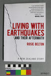
One softcover book titled 'Living with Earthquakes and the Aftermath: A New Zealand Story' by Rosie Belton. 185 pages. Signed by the author with a dedication to Canterbury Museum.

Canterbury Provincial Council and Supreme Court Buildings, Durham Street North.

Canterbury Provincial Council and Supreme Court Buildings, Durham Street North.

The September Canterbury earthquake. These pictures were taken of Colombo Street in Sydenham. A lot of masonry in this area has been damaged/fallen down.
Monumental masons is a gravestone maker.
Note: these photos were taken on a cellphone; mind the quality.

The September Canterbury earthquake. These pictures were taken of Colombo Street in Sydenham. A lot of masonry in this area has been damaged/fallen down.
This was a headstone makers store.
Note: these photos were taken on a cellphone; mind the quality.

Earthquake damage at the Arts Centre, Christchurch
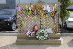
One landscape colour digital photograph taken 22 February 2017 showing an earthquake memorial trellis at the site of the former Canterbury Television building.
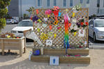
One landscape colour digital photograph taken 22 February 2017 showing an earthquake memorial trellis at the site of the former Canterbury Television building.

A view after the 7.1 magnitude earthquake in Christchurch.

Aftermath of September 4th Earthquake in Canterbury NZ. Bridge Street, South Brighton, Christchurch.

Aftermath of September 4th Earthquake in Canterbury NZ. Bridge Street, South Brighton, Christchurch.

One landscape colour digital photograph taken on 25 February 2011 showing damage to the Lyttelton Historical Museum on the corner of Gladstone Quay and Donald Street. The photograph shows bracing and safety fencing installed after the September 2010 earthquakes. Architect Closed after the September 2010 earthquakes, the Lyttelton Museum buildin...

One landscape colour digital photograph taken on 15 June 2011 showing earthquake damage to the Presbyterian Church of St John in Winchester Street, Lyttelton. Photograph shows the collapsed roof and tower. The photograph is taken from the southern side of the church. Architect The destructive force of the 14 June 2011 earthquakes on buildings in...

Aftermath of September 4th Earthquake in Canterbury NZ. Storm drains - Lower Styx Road, Brooklands.

One framed certificate issued to SCIRT in 2013 to mark winning The Press Champion Canterbury Supreme Award in the Medium-Large Enterprise category.

A view after the 7.1 magnitude earthquake in Christchurch.

Photos taken in Lyttelton on March 20 following the February 22 earthquake.
File reference: CCL-2011-03-20-After-The-Earthquake-P1110736
From the collection of Christchurch City Libraries
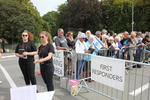
One landscape colour digital photograph taken 22 February 2017 showing the appointed first responders and public viewing areas at the Canterbury Earthquake Memorial Service.
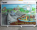
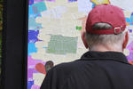
One large display board featuring an illustration of the various pipes under the roads.

Aftermath of September 4th Earthquake in Canterbury, NZ. Damage to store - corner of Gloucester and Woodham Road, Christchurch.

Telegraph Road was a straight road before the recent 7.1 magnitude earthquake. The fault ran right through here and now the road has a dramatic kink in it.