
None

None
None

This one was really flowing out of the ground.

Liquefaction and flooding on Avonside Drive. The street is closed off with cones and a "Road closed" sign, and portaloos line the street. The banks of the Avon River have been built up with gravel.

A photograph of a car and digger parked in front of a house. The photograph is captioned by BeckerFraserPhotos, "Odd juxtaposition of the digger with the car in Kingsford Street, Horseshoe Lake, Burwood".

A large crack between the road and a concrete slab in New Brighton. The photographer comments, "This is the gap that has been growing during all the Christchurch earthquakes. It is between Robbie's Restaurant and the car park in New Brighton".

Bare patches of ground at Sullivan Park in Avonside. The bare patches mark where liquefaction covered the grass after the 4 September 2010 earthquake. Damage to the footpath and road on Galbraith Avenue can also be seen.

Photograph captioned by BeckerFraserPhotos, "Bexley, Morganwood Street is in the centre of this picture. Also includes Velsheda Street, Wetlands Grove and Birch Street".

A photograph of tents and shipping containers in Hagley Park which were to be part of the Ellerslie International Flower Show. The show was cancelled in the aftermath of the 22 February 2011 earthquake.

University of Canterbury Vice-Chancellor Rod Carr, UCSA President Kohan McNab, and former Chancellor Rex Williams, speaking with a woman in the UCSA car park.

Photograph captioned by BeckerFraserPhotos, "25 Seabreeze Close, Bexley. View through the window shows the crack in the floor slab, and a pile of silt in the corner of the room".

A misaligned brick wall in front of a property with silt still piled up around it. During the earthquake, liquefaction drove silt to the surface where it erupted out of the ground like a volcano and formed a pile like the one seen here.

A flow chart depicting potential hazards earthquakes pose to coastal geography.

Buckled curbing along Jones Street in Kaiapoi. A pile of liquefaction can be seen in the foreground as well as a few plastic pipes. A number of portaloos line the street in the distance as well as road cones.

A photograph captioned by BeckerFraserPhotos, "A view down a driveway of houses on crazy angles. Liquefaction has been a problem here and slumping occurred under all these houses. The houses have been affected in different ways".

An abandoned residential property at 34 Waygreen Avenue in New Brighton. The front of the section is overgrown with weeds and silt from liquefaction. Cushions lie on the footpath. A blue sticker can be seen on the window.

The sunken footpath around the base of a power pole on Bracken Street in Avonside. Dry silt from liquefaction can be seen mixed in with the gravel around it as a result of the 4 September 2010 earthquake.

A view down New Brighton Road where silt from liquefaction still remains on the street curb. A power pole in the foreground is on a noticeable lean and a Port-a-loo can be seen to the right.

Damage to Medway Street in Richmond. The road surface is cracked and buckled, and covered in liquefaction silt. A temporary road sign restricting speed to 30 is visible, with road cones behind. The photographer comments, "Medway St, Woodchester Ave on right just beyond the 30 sign".

None

These were scattered across the park.

Robbie watches a sand volcano smother his driveway.

Damage to Christchurch city following the 22 February earthquake 2011. A crack in the road where the asphalt has lifted, possibly due to liquefaction. Cones have been placed along the crack to warn drivers of the irregular surface.

Severe damage on a New Brighton Road. It had to be reformed and raised up 40 cm. A pile of dried liquefaction has been shovelled onto the footpath. Road cones mark out the uneven surfaces on the road.

Photograph captioned by Fairfax, "Acland Ave and other nearby residents upset about houses that are green stickered being unliveable. They cannot access any relief funds. A meeting in the cul-de-sac where there are still piles of liquefaction".

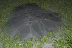
A sand volcano in the Halswell Primary School grounds. Sand volcanoes were caused by liquefaction where the soil loses its strength during the earthquake and the silt rises upwards, ejecting out of a hole like magma in a volcano.

A photograph captioned by BeckerFraserPhotos, "Down this drive at 193 New Brighton Road a group of eight units are sitting at a variety of angles. It's very hard to know what is vertical. Look at the liquefaction".

Cleaning up Manning Signs of the silt from liquefaction. Three fellow workers man the shovels while two building engineers talk to the boss (hidden). After doing the car park we then turned our hands to the inside of the factory, once clearance was given that we could go inside.

An abandoned residential property at 20 Waygreen Avenue in New Brighton. The section is covered with weeds and silt from liquefaction. 'HM' has been spray painted in green on the front wall of the house. The gutter has partly flooded.