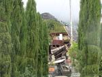
One landscape colour digital photograph taken on 25 February 2011 showing the damage to the former Anglican Vicarage on Ripon Street Lyttelton. Taken from the footpath. Architect The sense of loss felt when confronted with the collapse or demolition of an historic building is compounded when that building is also a home. While the community sees...

One landscape colour digital photograph taken on 25 February 2011 showing the temporary water tank installed on the grassy [local name for Lyttelton Main School Field] to provide drinking water for residents to collect when there was no town supply water. A temporary source of drinking water was needed following the 22 February 2011 earthquake...
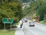
One landscape colour digital photograph taken on 1 March 2011 showing the road between Franklin and Queenstown with an electronic road work sign depicting the words 'Kia Kaha Christchurch'. People all around New Zealand participated in gestures of support for Christchurch following the 6.3 magnitude earthquake on 22 February 2011. In Queenstown...

One landscape colour digital photograph taken on 1 March 2011 showing the road between Franklin and Queenstown with an electronic road work sign depicting the words '12.51pm 2 minutes silence'. People all around New Zealand participated in gestures of support for Christchurch following the 6.3 magnitude earthquake on 22 February 2011. In Queens...

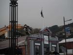
One landscape colour digital photograph taken on 22 March 2011 showing the demolition of the Dry Dock Pump House. Photograph taken from Brittan Terrace looking east over the Inner Harbour. Engineer The brick pump house for the Lyttelton Graving or Dry Dock was damaged in the 22 February 2011 Earthquake. Lyttelton Port of Christchurch decided to...

One landscape colour digital photograph taken on 22 March 2011 showing the demolition of the Dry Dock Pump House. Photograph taken from Cyrus Williams Quay beside the Cattle Jetty showing the southern side of the building. Engineer The brick pump house for the Lyttelton Graving or Dry Dock was damaged in the 22 February 2011 Earthquake. Lyttelt...

One landscape colour digital photograph taken on 11 May 2011 showing the town of Lyttelton looking north from the footpath of the Oxford Street Over bridge. The Lyttelton streetscape has changed dramatically from its pre-earthquake appearance and will continue to change as new buildings are erected on empty sections. In this photograph the dome...
One landscape colour digital photograph taken on 15 April 2011 showing the demolition of Coastal Living Design Store on London Street. In Christchurch's Central Business District many of the high profile demolitions took place out of public view in the Red Zone. By contrast, the demolitions on London Street after the 22 February 2011 earthquake...

Photograph captioned by Fairfax, "Christchurch earthquake. Canterbury University. Steven Joyce Tertiary Education Minister's visit to Central Library. Earthquake damage to computers and shelves and ceiling".

Photograph captioned by Fairfax, "Christchurch earthquake. Canterbury University. Steven Joyce Tertiary Education Minister's visit to Central Library. Earthquake damage to computers and shelves and ceiling".

Photograph captioned by Fairfax, "Christchurch earthquake. Canterbury University. Steven Joyce Tertiary Education Minister's visit to Central Library. Earthquake damage to computers and shelves and ceiling".

Band Together - Concert for Canterbury
www.bandtogetherforcanterbury.co.nz
23rd October 2010
Free concrete in Hagley Park following the 4th September 2010 earthquake

Damage to the facade of the Church of St Luke the Evangelist after the 4th of September earthquake. Barred off with "KEEP CLEAR" tape and road cones.

Damage to the Visitors Centre in Kaiapoi, after the September 4th earthquake. The foundations have lifted at the back of the building, giving it a forward lean.

The cartoon shows the letters of the name 'Christchurch' as blocks of stone that have collapsed into a pile of rubble; on top is a single rose. Refers to the Christchurch earthquake of Saturday 4th September 2010.
Quantity: 1 digital cartoon(s).

Neighbours across the river showing earthquake damage. Hotel Grand Chancellor in the background.
File reference: CCL-2011-08-12-CanterburyPublic Library pre-demolition-044
From the collection of Christchurch City Libraries.

A photograph captioned by Paul Corliss, "Creyke Road, Ilam. Post earthquake".

Reinforcing the apex of the clocktower gable.

A photograph of the earthquake damage to the Canterbury Provincial Chambers Building on Durham Street.

A photograph of the earthquake damage to the Canterbury Provincial Chambers Building on Durham Street.

A photograph of the earthquake damage to the Canterbury Provincial Chambers Building on Durham Street.

A photograph of the earthquake damage to the Canterbury Provincial Chambers Building on Durham Street.

A photograph of the earthquake damage to the Canterbury Provincial Chambers Building on Durham Street.

A photograph of the earthquake damage to the Canterbury Provincial Chambers Building on Durham Street.

A photograph of the earthquake damage to the Canterbury Provincial Chambers Building on Durham Street.

A photograph of the earthquake damage to the Canterbury Provincial Chambers Building on Durham Street.

A photograph of the earthquake damage to the Canterbury Provincial Chambers Building on Durham Street.

A photograph of the earthquake damage to the Canterbury Provincial Chambers Building on Durham Street.

A photograph of the earthquake damage to the Canterbury Provincial Chambers Building on Durham Street.

A photograph of the earthquake damage to the Canterbury Provincial Chambers Building on Durham Street.