
An aerial view of the Port Hills a week after the 22 February 2011 earthquake. An army truck can be seen.

Aerial image of the CTV Building site on Madras Street, taken by the Royal New Zealand Air Force for the Earthquake Commission.

An aerial photograph looking south west over the Christchurch CBD with the Avon River visible to the left and Hagley Park in the distance.

An aerial view of Lyttelton a week after the 22 February 2011 earthquake.

An aerial photograph captioned by BeckerFraserPhotos, "High, Lichfield, and Manchester Streets intersection".

An aerial photograph of the Horseshoe Lake area, with Queensbury Street in the centre.

An aerial photograph of Jean Batten Place in the Horseshoe Lake residential area.

An aerial photograph of a residential area in Burwood with the demolished site of the QE II stadium in the background.

An aerial photograph of Armagh Street near New Regent Street with the Forsyth Barr building to the left.

An aerial view of Christchurch a week after the 22 February 2011 earthquake. High Street can be seen.

Aerial image of Cathedral Square taken by the Royal New Zealand Air Force for the Earthquake Commission. The damaged Press Building can be seen.

An aerial photograph looking south west over Armagh Street with Victoria Square in the bottom right, the Forsyth Barr Building to the left and the Victoria Apartments to the right.

An aerial photograph of a residential area in New Brighton, with the New Brighton Mall and the pier in the distance.

An aerial view of Christchurch a week after the 22 February 2011 earthquake. The PGC Building on Cambridge Terrace can be seen.

An aerial view of Christchurch a week after the 22 February 2011 earthquake. The Oxford Terrace Baptist Church can be seen.

An aerial view of Christchurch a week after the 22 February 2011 earthquake. Manchester and Gloucester Streets can be seen.

An aerial view of Christchurch a week after the 22 February 2011 earthquake. The Hotel Grand Chancellor can be seen.

An aerial photograph looking south west over Armagh Street, with the Forsyth Barr Building and Victoria Apartments to the left, and Victoria Park to the right.

Aerial image of Lyttelton taken by the Royal New Zealand Air Force for the Earthquake Commission.

Aerial image of Lyttelton taken by the Royal New Zealand Air Force for the Earthquake Commission.

Aerial image of the Cathedral of the Blessed Sacrament on Barbadoes Street, taken by the Royal New Zealand Air Force for the Earthquake Commission.

Aerial image of the Christchurch City Centre taken by the Royal New Zealand Air Force for the Earthquake Commission. The Knox Church can be seen.

An aerial photograph of Victoria Square and the Crowne Plaza Hotel.

Aerial image of a residential area of Christchurch taken by the Royal New Zealand Air Force for the Earthquake Commission. Porritt Park is visible on the right of the photograph.

An aerial view of Christchurch a week after the 22 February 2011 earthquake. The Hotel Grand Chancellor can be seen.

An aerial view of Hagley Park a week after the 22 February 2011 earthquake, with liquefaction visible on the golf course.

An aerial view of Christchurch a week after the 22 February 2011 earthquake. The PGC Building on Cambridge Terrace can be seen.

An aerial view of Christchurch a week after the 22 February 2011 earthquake. Christ's College and the Canterbury Museum can be seen.
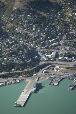
Aerial image of Lyttelton taken by the Royal New Zealand Air Force for the Earthquake Commission.

An aerial photograph of the Christchurch central city with Gloucester Street running through the centre of the photograph, and Clarendon Towers in the middle.