
Demolition (Deconstruction) of the partially pancaked multi story car park above the old Smith City building. Taken from the Moorhouse-Colombo Street flyover.

Photo taken Jan 2011 as the church is demolished.

Another hole has appeared in the street where a building has been demolished. Selwyn Dealers next door sensibly moved all their stock away from the adjoining wall just in case.

The base of the tower on the right of this picture has sunk about 25cm so that the lower course of bricks have disappeared below ground level. Meanwhile the other end of the building has sunk about 50cm splitting the building into thirds. The sand you can see is what came bubbling up out of the ground due to liquifaction. Unfortunately the build...

The bridge on River Road just before the Banks Ave turn off. Looking down at the Avon River side of the Shirley Stream bridge showing how much the ground has slumped by - notice the unpainted concrete now exposed.

Looked like a nice stereo they had.

Lyttelton Harbour at dusk.

Text reads 'Uses for Christchurch rubble?...' The cartoon shows a bridge made partially of earthquake rubble leading from Lyttelton Harbour to Diamond Harbour on Banks Peninsula. Someone in a van says 'At long last... A bridge to Diamond Harbour!' And someone else says 'And somewhere to fish!' Context - Rubble from the earthquake may be used for the construction of watersides and bridges. This cartoon is a fanciful use for Christchurch earthquake rubble. Currently a ferry connects Diamond Harbour to Lyttelton, on the harbour's northern shore. In combination with buses from Lyttelton to downtown Christchurch, this allows residents of Diamond Bay to commute to the city.
Quantity: 1 digital cartoon(s).

Photograph captioned by BeckerFraserPhotos, "Lyttelton Harbour looking jewel-like in spring sunshine".
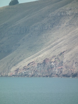
Landslides around Lytteton Harbour.

Landslides around Lytteton Harbour.
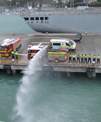
Members of the New Zealand Fire Service spraying water into Lyttelton Harbour.

Photograph captioned by Fairfax, "Quake: Lyttelton: Volunteer fireman in Diamond Harbour Karl Lloyd, picking up food from Diamond Harbour Jetty delivered by the navy".

Photos taken in Lyttelton on March 20 following the February 22 earthquake.
File reference: CCL-2011-03-20-After-The-Earthquake-P1110736
From the collection of Christchurch City Libraries

Members of the New Zealand Fire Service spraying water into Lyttelton Harbour as the HMNZS Otago departs.

An image from a Navy Today April 2011 article titled, "The Port". The image is a chart of the Lyttelton Harbour, Whakaraupo.

Photos taken in Lyttelton following the February 22 earthquake.
File ref: CCL-2011-03-05-After-The-Earthquake-P1110602
From the collection of Christchurch City Libraries

Photograph captioned by Fairfax, "Lyttelton harbour".

Photograph captioned by BeckerFraserPhotos, "87 Harbour Road in Brooklands, now an empty site. The land has now been red zoned".

None

A camera operator filming the return of the HMNZS Canterbury to the Lyttelton Harbour after a trip to Wellington to resupply.

Photograph captioned by BeckerFraserPhotos, "Lyttelton Harbour".

A graphic showing cruise ships in Akaroa harbour.

A view of Lyttelton Harbour from Dyer's Pass.

Due to the 7.1 earthquake on 4th September 2010 and then the following earthquakes Godley House has suffered severe damage. Godley house was built in 1880 by Harvey Hawkins - see www.godleyhouse.co.nz/

A photograph of the Harbour Board building in Lyttelton.

Photograph captioned by Fairfax, "Lyttelton harbour following Canterbury's earthquakes".

An aerial photograph captioned by BeckerFraserPhotos, "Lyttelton Harbour".

A photograph captioned by Paul Corliss, "Lyttelton inner harbour moorings".

A photograph captioned by Paul Corliss, "Lyttelton inner harbour moorings".