
Detail of damage to a building on Ferry Road. The side walls have partially collapsed, and part of the brick wall is bowing outwards in danger of further collapse.

Damage to a building on Ferry Road. The side walls have partially collapsed, and bricks are scattered on the ground below. The building is cordoned off with security fencing.

Damage to a building on Ferry Road. The side walls have partially collapsed, and bricks are scattered on the ground below. The building is cordoned off with security fencing.

Damage to a building on Ferry Road. The side walls have partially collapsed, and bricks are scattered on the ground below. The building is cordoned off with security fencing.

Detail of damage to a building on Ferry Road. The side walls have partially collapsed, and part of the brick wall is bowing outwards in danger of further collapse.

Damage to a building on Ferry Road. The side walls have partially collapsed, and bricks are scattered on the ground below. The building is cordoned off with security fencing.

Damage to a building on Ferry Road. The side walls have partially collapsed, and bricks are scattered on the ground below. The building is cordoned off with security fencing.

Shops and buildings down Ferry Road.

Silt from liquefaction and road damage around businesses on Ferry Road in Woolston.

Silt from liquefaction and road damage around businesses on Ferry Road in Woolston.

Photograph captioned by BeckerFraserPhotos, "Demolition site of the Salvation Army shop, 636 Ferry Road".

Photograph captioned by BeckerFraserPhotos, "689 Ferry Road - demolition site of Woolston Community Library".

Photograph captioned by BeckerFraserPhotos, "Liquefaction almost one metre deep in the car park at 1070 Ferry Road, Christchurch".

The brick wall of a building in Redcliffs that has cracked and fallen away in some places. Sections of the wall have buckled out from the building's structure.
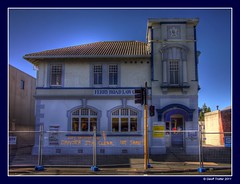
Sadly the days are numbered after the 6.3 quake that hit Christchurch 22 February 2011! You can see the blue streel strengthening on the tower from the earthquake on 4 September 2010. Also if you look closely you can see the cracks that have determained its fate! Press L.

A digital copy of a pen and ink and watercolour painting by Raymond Morris, titled, 'Woolston Community Library, Ferry Road'.

Liquefaction silt beside buildings on Ferry Road.

Liquefaction silt beside buildings on Ferry Road.

Liquefaction silt beside buildings on Ferry Road.

Liquefaction silt beside buildings on Ferry Road.

A building being demolished on Ferry Road.

Ferry Road, heading towards Redcliffs and Sumner.

A photograph captioned by Paul Corliss, "Old A & T Burts building, Ferry Road, Woolston".

Photograph captioned by BeckerFraserPhotos, "Demolition site of Big Ed's Fish and Chips, 628 Ferry Road".

A photograph of street art on Ferry Road. The photographer attributes the work to APEK.

A photograph taken out the window of a car on Ferry Road near the intersection with Ensors Road. In the distance, a group of people in high-visibility vests and hard hats can be seen congregating in front of a shop.

A photograph of the earthquake damage to a block of shops along Ferry Road. The top of the brick walls have crumbled. The fallen bricks have been cleared from the footpath below. Wire fencing, road cones and police tape have been used as a cordon.

Liquefaction silt which has been partly cleared from in front of businesses on Ferry Road. A damaged part of the footpath has also been filled in with gravel.

A photograph captioned by BeckerFraserPhotos, "580 Ferry Road. Many demolition sites have been planted with wildflowers by local schools. This is one of the more exuberant".

A photograph captioned by BeckerFraserPhotos, "580 Ferry Road. Many demolition sites have been planted with wildflowers by local schools. This is one of the more exuberant".