
Search
found 12650 results
Digital Photograph: Earthquake Damage to Lyttelton Historical Museum, Glad…
Images, Canterbury Museum
One landscape colour digital photograph taken on 25 September 2011 showing the site of the Lyttelton Historical Museum on the corner of Gladstone Quay and Donald Street. The photograph shows the temporary fencing around the levelled site. The building visible at the rear is the former Municipal Stables on Donald Street. To the right of the phot...

Digital Photograph: Earthquake Damage to Lyttelton Historical Museum on Gl…
Images, Canterbury Museum
One landscape colour digital photograph taken on 14 July 2011 showing damage to the Lyttelton Historical Museum on the corner of Gladstone Quay and Donald Street. The photograph shows the safety fencing and containers installed after the 22 February 2011 earthquakes. Architect Closed after the September 2010 earthquakes, the Lyttelton Museum bu...

Digital Photograph: Artwork on the Site of the Harbourlight Theatre, Londo…
Images, Canterbury Museum
One portrait colour digital photograph taken on 23 July 2011 showing the artwork by Trent Hiles erected on the site of the Harbourlight Theatre on London Street. The artwork presents part of James K Baxter's poem 'High Country Weather' using the international code of signal flags. The artwork was installed as a Gap Filler project. The artwork r...

Digital Photograph: Former Convent of Our Lady of Mercy, Exeter Street, an…
Images, Canterbury Museum
One landscape colour digital photograph taken on 30 June 2011 showing earthquake damage to the former Convent of Our Lady of Mercy and to the Catholic Church of St Joseph the Worker. Photograph taken from St. Davids Street The sense of loss felt when confronted with the collapse or demolition of an historic building is compounded when that bui...

Digital Photograph: Temporary Premises of Lyttelton Bakery, corner of Norw…
Images, Canterbury Museum
One landscape colour digital photograph taken on 16 June 2011 showing the Lyttelton Bakery operating from a portable building on the Corner of Canterbury Street and Norwich Quay. This portable building has been placed on the site of the Royal Hotel. Also visible in the photograph are Shadbolt House and the rear of the buildings on the south side...

Digital Photograph: Earthquake damage to the Lyttelton Timeball Station.
Images, Canterbury Museum
One landscape colour digital photograph taken on 16 June 2011 showing the site of the Timeball Station after its collapse. Part of the ground floor remains visible. Photograph taken from Oxford Street Overbridge. Architect The 13 June 2011 earthquakes caused the collapse of the already damaged Lyttelton Timeball Station. After the 22 February ...

Digital Photograph: Earthquake damage to Church of the Most Holy Trinity, …
Images, Canterbury Museum
One landscape colour digital photograph taken on 15 June 2011 showing earthquake damage to the Anglican Church of The Most Holy Trinity in Winchester Street, Lyttelton. Photograph shows collapsed roof of the nave and north transept. Photograph taken from the north side of the church. Architect The collapse of the Church of the Most Holy Trinity ...
Digital Photograph: Earthquake Damage to Lyttelton Roman Catholic and Diss…
Images, Canterbury Museum
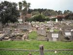
One landscape colour digital photograph taken on 30 June 2011 showing earthquake damage to graves in Lyttelton Roman Catholic and Dissenters (Public) Cemeteries in Reserve Terrace. Most of the headstones and grave surrounds in the photograph show damage. Looking east in the Dissenters (Public) section of the cemetery. The Lyttelton cemeteries a...

Digital Photograph: Earthquake Damage to Lyttelton Roman Catholic and Diss…
Images, Canterbury Museum
One landscape colour digital photograph taken on 30 June 2011 showing signs warning of the danger posed by unstable headstones in Lyttelton Roman Catholic and Dissenters (Public) Cemeteries in Reserve Terrace. Several toppled headstones and collapsed grave surrounds are visible in the photograph. Looking east from the main gate. The Lyttelton c...

Digital Photograph: Earthquake damage to a retaining wall, Lyttelton
Images, Canterbury Museum
One landscape colour digital photograph taken on 30 June 2011 showing earthquake damage to a section of retaining wall in Sumner Road. Plastic sheeting installed to stabilise previous damage and protect from water erosion is visible to the right of the photograph. Also visible in the photograph is a boarded up broken window and temporary safety ...

Digital Photograph: Earthquake damage to Church of the Most Holy Trinity, …
Images, Canterbury Museum
One landscape colour digital photograph taken on 15 June 2011 showing earthquake damage to the Anglican Church of The Most Holy Trinity in Winchester Street, Lyttelton. Photograph shows collapsed roof of the nave and north transept. Photograph taken from the northwest corner of the church. Architect The collapse of the Church of the Most Holy Tr...

Digital Photograph: Demolition of former Library and Fire Station, corner …
Images, Canterbury Museum
One landscape colour digital photograph taken on 6 September 2011 showing the demolition of 2 Sumner Road, the former library and fire station. This building was a private residence at the time of its demolition. Photograph taken looking north on Oxford Street. Also visible in the photograph are the Lyttelton Information Centre, an entrance to ...
Nisbet, Alastair, 1958- :'Convention Centre'. 15 October 2012
Images, Alexander Turnbull Library
A man labeled `rate payers' lifts an elephant labeled `convention centre' high over his head. Refers to recent calls for tenders from groups to build a new convention centre in Christchurch. Quantity: 1 digital cartoon(s).
"I can't get hold of anyone at Treasury! I wanted to ask them how they wer…
Images, Alexander Turnbull Library
The minister wants to ask people at Treasury how they are getting on with all the unexpected expenses but cannot get them on his cellphone. His adviser tells him that they are all out holding garage sales and sausage sizzles. Quantity: 1 digital cartoon(s).
Evans, Malcolm Paul, 1945- :"Hello EQC here! - you know how the quakes lef…
Images, Alexander Turnbull Library
The Earthquake Commission calls a householder and tells him the 'good news' that his house which was left by the earthquakes in 'such an angle you couldn't live in it' has been refloated by the recent heavy rain and is now level again. The 'bad news' is that the house was last seen floating in the sea off Sumner. In June 2013 heavy rains had caused flooding in Canterbury. Christchurch was affected especially in the liquefaction prone areas, where the ground had sunk because of the earthquakes. Colour and black and white versions available Other Titles - Evans, Malcolm Paul, 1945-:"Established in a conservation estate...likely to harm our unique flora and fauna..." 31 May 2013 Quantity: 2 digital cartoon(s).
Nisbet, Alastair, 1958- :Avon River to be altered in the east?... 4 August…
Images, Alexander Turnbull Library
Shows a aerial representation of Christchurch's eastern suburbs with the course of the Avon River. The new river course spells the word 'munted'. Quantity: 1 digital cartoon(s).
Evans, Malcolm Paul, 1945-:Rebuilding Projects. 29 March 2011
Images, Alexander Turnbull Library
Text reads 'Rebuilding projects'. The first of the two frames shows collapsed buildings in Christchurch after the earthquake and the second frame shows leader of the Labour Party Phil Goff sorely in need of 'credibility' as he makes the 'V' for victory sign with both hands. Context - the rebuilding of Christchurch after the earthquake of 22 March 2011 and Phil Goff's disastrous personal polling as 'preferred PM' and the concomitant problems for the Labour Party with elections in November of this year. Colour and black and white versions of this cartoon are available Quantity: 2 digital cartoon(s).
Paul and Sam Corliss's Street Art Photograph (2011:07:13 04:42:33)
Images, UC QuakeStudies
A photograph of street art on the wall of a building on Colombo Street. The artwork is by Otis Frizzell and depicts police officer Constable Nao Yoshimizu comforting the grieving relative of an earthquake victim. Constable Yoshimizu acted as liaison officer for the families of Japanese victims of the earthquake. The mural was commissioned by the New Zealand Police as a recruitment advertisement.
Photograph by Neil Macbeth 271
Images, UC QuakeStudies
A member of the New Zealand Fire Service in a cherry picker spraying water at the fire burning in the collapsed Canterbury Television Building. Smoke is billowing out of the intact section of the building. Below, emergency personnel are searching the rubble for trapped people. A piece of corrugated plastic is being used to slide pieces of debris off the site.
Twisted Memories
Images, UC QuakeStudies
A digitally manipulated photograph of the badly twisted Medway Street footbridge. The photographer comments, "This bridge over the Avon River in Christchurch, New Zealand has been left in place since the first major earthquake back in September 2010. Graffiti artists or taggers are still leaving their marks on it even though it is nearly twisted at 90 degrees at one point".
Kissed By an Earthquake
Images, UC QuakeStudies
A digitally manipulated photograph of broken windows on Shadbolt House. The photographer comments, "This was close to the start of the demolition of the earthquake damaged Shadbolt House building in the Port of Lyttelton, New Zealand. In the bright sun the glass reflected the blue sky, but the broken windows only reflected the blackness of the interior of the empty broken building".
WEMO ERT Set 1 - March 2011 - Photograph 99
Images, UC QuakeStudies
A photograph looking west down Cashel Street from the intersection of Colombo Street. A member of the New Zealand Police is sitting on an armchair near the intersection. Behind him is a HireQuip generator. Several signs from nearby businesses are on his left and right. In the background there are large piles of rubble from earthquake-damaged buildings on the street.
Nisbet, Alastair, 1958- :Hope and Wire. 12 September 2012
Images, Alexander Turnbull Library
Depicts spoof poster of new Zealand television series 'Hope and Wire' starring American actors as Bob Parker, Christchurch Mayor, Gerry Brownlee, Canterbury Earthquake Recovery Minister, Roger Sutton, CERA CEO, Andrew Holden, Editor The Press. Context: a six part television series will be set in Christchurch in the aftermath of the earthquakes (Stuff 11 September 2012). Quantity: 1 digital cartoon(s).
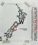
Poster with tube: United We Stand
Images, Canterbury Museum
One limited edition poster with tube and information sheet. The poster has initial letters of the cities of New Zealand arranged to form an outline of the country. All are printed in black, except the 'C' of Christchurch which stands out in red. "United We Stand, 22 Feb 2011, 12.51pm" is printed in black. Poster commemorates the 2011 Christchurc...
Nisbet, Alistair, 1958- :'Quick! Fill it in before it climbs back out!' 1 …
Images, Alexander Turnbull Library
Prime Minister John Key tells the Minister for Earthquake recovery, Gerry Brownlee, to 'fill it in before it climbs back out!' Gerry Brownlee is sweeping rubble into a deep pit. The rubble represents many of the problems that New Zealand faces like Pike River, earthquakes, the Rena, child abuse, Winston Peters, gas pipeline damage and so on. Quantity: 1 digital cartoon(s).
Was it something we said? 23 September 2010
Images, Alexander Turnbull Library
A weather map of New Zealand is shown beset with dreadful weather conditions that include cyclones and lightning strikes; there is also earthquake activity around the Canterbury region. Text reads 'Was it something we said?...' Refers to the Canterbury earthquake of 4th September 2010 and the spring storms with wind, rain and snow in recent weeks. Quantity: 1 digital cartoon(s).

Christchurch, NZ - Post Feb Earthquake, 2011
Images, eqnz.chch.2010
Damage to the Hotel Grand Chancellor can be seen in the middle. At the bottom left is the lift shaft (now fully demolished) of the CTV building which claimed over 100 lives when it collapsed in the earthquake. Taken during a scenic flight over Christchurch, New Zealand, 3 months after the deadly earthquake of 22 February, 2011. Much of the inn...

20130622_7842_1D3-24 Disabled in more ways than one (Day 173/365)
Images, eqnz.chch.2010
One of many disabled carparks outside what used to be one of the great sporting complexes in New Zealand. The Queen Elizabeth II Park complex in north-east Christchurch was built initially for the 1974 Commonwealth Games and was used for track and field and the adjoining pool complex had swimming and diving. It was built on an area that was used...

Christchurch, NZ - Post Feb Earthquake, 2011
Images, eqnz.chch.2010
The current state of the Christchurch Cathedral can be seen in the middle. The spire collapsed as a result of the earthquake. Taken during a scenic flight over Christchurch, New Zealand, 3 months after the deadly earthquake of 22 February, 2011. Much of the inner city CBD is still cordoned off and will be for some time. About 900 buildings are ...

The "Shake Up"
Images, eqnz.chch.2010
Christchurch city experienced a magnitude 7.1 earthquake on September 4, at 4:35 am. The epicentre was 40 km west of the city. It is the most damaging earthquake in New Zealand since the Hawke's Bay earthquake in 1931, but there was no loss of life. It was fortunate the earthquake occurred when the central city streets were deserted, as there ...