Search
found 10153 results
All Right? Social Media: Facebook Cover Photo 15
Images, UC QuakeStudies
A photograph of a large All Right? banner on a temporary hoarding around the McKenzie and Willis building in the central city. The photograph was used as a cover photo on the All Right? Facebook page. All Right? posted the photograph on their Facebook page on 21 April 2014 at 10:18pm.

Digital Photograph: Lyttelton Ambulance Station, north side of London Stre…
Images, Canterbury Museum
One landscape colour digital photograph taken on 19 November 2011 showing buildings on London Street. Visible in the photograph (left to right) are Lyttelton Ambulance Station and Bells Pharmacy - relocated into a converted house with law firm MacTodd on the upper floor. Discussions have been held between Lyttelton Police, St John Ambulance and...

Digital Photograph: Temporary Bank of New Zealand Branch, north side of Lo…
Images, Canterbury Museum
One landscape colour digital photograph taken on 19 November 2011 showing the temporary premises of the Bank of New Zealand in a relocatable building on the footpath. The sign above the tellers window read "Lyttel Bank" The Lyttelton streetscape has changed dramatically from its pre-earthquake appearance and will continue to change as new build...
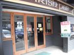
Digital Photograph: Irish Pub, south side of London Street, Lyttelton
Images, Canterbury Museum
One landscape colour digital photograph taken on 19 November 2011 showing earthquake repairs being undertaken to the Irish Pub on the south side of London Street. The Lyttelton streetscape has changed dramatically from its pre-earthquake appearance and will continue to change as new buildings are erected on empty sections. In this photograph Lo...

Digital Photograph: Temporary Artwork on the corner of London and Canterbu…
Images, Canterbury Museum
One landscape colour digital photograph taken on 19 November 2011 showing a temporary artwork on the site of the Albion Hotel/ Ground Delicatessen. After the demolition of the building the site was used for a Gap Filler initiative called the Lyttelton Petanque Club. The photograph shows a temporary artwork created from used bricks, probably from...

Digital Photograph: The Loons (Lyttelton Working Mens' Club), Canterbury S…
Images, Canterbury Museum
One landscape colour digital photograph taken on 19 November 2011 showing temporary propping of the Lyttelton Working Mens' Club/ The Loons. Built in 1909 the building has had a variety of uses including a garage and the Lyttelton Waterside Workers Social Club. More recently the Lyttelton Working Mens' Club has provided rehearsal and performanc...

Digital Photograph: Posters in the Window of Leslie's Bookshop, London Str…
Images, Canterbury Museum
One landscape colour digital photograph taken on 19 November 2011 showing posters for the outdoor theatre production 'The Pirates of Corsair Bay' and the 2011 Lyttelton Summer Festival events scheduled for February and March 2011. The posters remained in the window of the red stickered building until it was demolished in early September 2012. A...

Digital Photograph: Elevated view of London Street, Lyttelton
Images, Canterbury Museum
One landscape colour digital photograph taken on 26 May 2013 of London Street, Lyttelton. The photograph was taken from St Davids Street looking west. The roofs of the portable buildings forming the temporary Lyttelton Police station are visible in the foreground. The Lyttelton Port Company offices and Tunnel Portal are prominent in the midgrou...

Digital Photograph: Demolition of former Library and Fire Station, corner …
Images, Canterbury Museum
One landscape colour digital photograph taken on 6 September 2011 showing the demolition of 2 Sumner Road, the former library and fire station. This building was a private residence at the time of its demolition. Photograph taken looking north on Oxford Street. Also visible in the photograph are the Lyttelton Information Centre, an entrance to ...
Elizabeth Ackermann Photograph 165
Images, UC QuakeStudies
A photograph of a man cooking sausages outside the Avonhead Baptist Church for the administrators and technicians from the Department of Civil and Natural Resources Engineering at the University of Canterbury. The students and staff from this department used the church as a base after the 22 February 2011 earthquake, until their building on campus was deemed safe to enter.
Dan Neely WEMO Photograph 06
Images, UC QuakeStudies
A photograph of a block of damaged shops on the corner of Gloucester Street and Woodham Road. The top of the façade has crumbled. The bricks have fallen to the ground and taken the awnings with them. Wire fencing has been placed around the buildings as a cordon. Signs on the fences indicated that the T Bakery and Red Chilli are open.
Photograph by Neil Macbeth 069
Images, UC QuakeStudies
One end of the Arts Centre photographed shortly after the 22 February 2011 earthquake. The gable of the building has crumbled and fallen to the ground, collapsing an awning. A large crack can be seen in the corner tower. Blue ties can be seen at the top of the tower, used to brace the structure after the 4 September 2010. This has probably limited the damage caused by the 22 February 2011 earthquake.
Photograph by Neil Macbeth 532
Images, UC QuakeStudies
A view across Montreal Street to the Christchurch Art Gallery. The building was used as the headquarters for Civil Defence in the aftermath of the 22 February 2011 earthquake, and large white marquees have been set up in its forecourt to accommodate extra personnel. The site is surrounded by a safety fence. On the left is a sign advertising the "Van der Velden: Otira" exhibition, which was cut short by the earthquake.
Mark Lincoln Photograph 179
Images, UC QuakeStudies
Shoppers and tourists in the Re:Start mall. The photographer comments, "The new temporary city mall has been open in Christchurch now for a week. Buildings damaged in the earthquake have been demolished and replaced with cargo containers to create a new, temporary, Cashel Mall. I visited the mall yesterday and was quite impressed with what they have done. The cargo containers have been nicely converted, brightly painted and smartly branded to create some good looking stores".
Mark Lincoln Photograph 085
Images, UC QuakeStudies
A damaged car sits on top of the rubble of the Bealey Pharmacy. The photographer comments, "Bealey Avenue is open to traffic, as are many of the side streets, and the damage to buildings along this street is quite impressive and perhaps just a small taste of the damage that lies beyond the cordon ... A new feature now also appears to be a large pile of rubble with a new looking red Holden placed on top. Weird".
A Design for a New Christchurch Cathedral
Images, UC QuakeStudies
A proposed design by John Raven for a new cathedral, tied to a cordon fence. Clarendon Tower can be seen in the background. The photographer comments, "Someone is asking for designs for a new Christchurch Cathedral after it was announced that the old historical building will not be repaired, to be put on the fences through which people can see the de-construction of the old one. This design looks a great one to me".
Observatory Tower Photograph 21
Images, UC QuakeStudies
A photograph of the rubble from the Observatory tower in the South Quad of the Christchurch Arts Centre. The tower collapsed during the 22 February 2011 earthquake. A digger was used to clear the rubble away from the building. Scaffolding constructed around the tower has also collapsed and is amongst the rubble. A car and the bumper of another car can be seen under the rubble.
BeckerFraserPhotos April 2011 photograph 444
Images, UC QuakeStudies
Moira Fraser standing in front of the 'Passing Time' sculpture on the corner of St Asaph Street and Madras Street. 'Passing Time' was installed outside the CPIT Building for the 6th SCAPE (a contemporary public art programme in Christchurch) a few days prior to the 22 February 2011 earthquake. The work features twisting boxes depicting each year between 1906 (the founding of CPIT) and 2010 (the date of the sculpture's production).
BeckerFraserPhotos April 2011 photograph 397
Images, UC QuakeStudies
A plaque on the ground in front of the 'Passing Time' sculpture on the corner of Madras Street and St Asaph Street. The 'Passing Time' sculpture was installed outside the CPIT Building for the 6th SCAPE (a contemporary public art programme in Christchurch) a few days prior to the 22 February 2011 earthquake. The work features twisting boxes depicting each year between 1906 (the founding of CPIT) and 2010 (the date of the sculpture's production).
BeckerFraserPhotos April 2011 photograph 398
Images, UC QuakeStudies
Moira Fraser standing in front of the 'Passing Time' sculpture on the corner of St Asaph Street and Madras Street. 'Passing Time' was installed outside the CPIT Building for the 6th SCAPE (a contemporary public art programme in Christchurch) a few days prior to the 22 February 2011 earthquake. The work features twisting boxes depicting each year between 1906 (the founding of CPIT) and 2010 (the date of the sculpture's production).
BeckerFraserPhotos April 2011 photograph 401
Images, UC QuakeStudies
Moira Fraser in front of the 'Passing Time' sculpture on the corner of St Asaph Street and Madras Street. 'Passing Time' was installed outside the CPIT Building for the 6th SCAPE (a contemporary public art programme in Christchurch) a few days prior to the 22 February 2011 earthquake. The work features twisting boxes depicting each year between 1906 (the founding of CPIT) and 2010 (the date of the sculpture's production).
Photograph by Jocelyn Kinghorn 2435
Images, UC QuakeStudies
An access point into the CBD cordon at the corner of Gloucester and Oxford Terrace. Road cones and fencing can be seen in the background with a sign saying 'Access point. Hours of operation 6am-7pm daily. Outside this house use Manchester St/Cambridge Terrace access point'. Inside the cordon, a station can be seen on the left, as well as some workers and cars. The demolition site at the back is where the Brannigans Building used to be.
Observatory Tower Photograph 33
Images, UC QuakeStudies
A photograph of the rubble of the Observatory tower in the South Quad of the Christchurch Arts Centre. The tower collapsed during the 22 February 2011 earthquake. A digger was used to clear the rubble away from the building. Scaffolding constructed around the tower has also collapsed and is amongst the rubble. In the background is the damaged tower with a tarpaulin draped over the top.
Observatory Tower Photograph 16
Images, UC QuakeStudies
A photograph of the earthquake damage to the Observatory tower at the Christchurch Arts Centre. The top two storeys of the tower collapsed during the 22 February 2011 earthquake and the rubble spilled into the courtyard in front. A digger was used to clear the rubble away from the building. A tarpaulin has been draped over the top of the broken tower and the roof behind.
Observatory Tower Photograph 17
Images, UC QuakeStudies
A photograph of the earthquake damage to the Observatory tower at the Christchurch Arts Centre. The top two storeys of the tower collapsed during the 22 February 2011 earthquake and the rubble spilled into the courtyard in front. A digger was used to clear the rubble away from the building. A tarpaulin has been draped over the top of the broken tower and the roof behind.
Observatory Tower Photograph 15
Images, UC QuakeStudies
A photograph of the rubble of the Observatory tower in the South Quad of the Christchurch Arts Centre. The tower collapsed during the 22 February 2011 earthquake and a digger was used to clear the rubble away from the building. Scaffolding constructed around the tower has also collapsed and is amongst the rubble. In the background is the damaged tower with a tarpaulin draped over the top.
WEMO ERT Set 1 - March 2011 - Photograph 104
Images, UC QuakeStudies
A photograph of the earthquake damage to a group of shops on Colombo Street near the intersection of Kilmore Street. Large sections of the top storeys of the buildings have collapsed. Most of the bricks and other rubble have been cleared from the footpath. USAR codes have been spray-painted on many of the shops' windows. The closest store has been demolished and the rubble has been cleared away.
New Bulbs Please
Images, UC QuakeStudies
Detail of a light fitting outside the former Ozone Hotel in North New Brighton. The photographer comments, "The broken light fitting is on the Ozone Hotel, which is red stickered after the 22 February 2011 earthquake in Christchurch. They will need to fix the building before this light gets a new bulb. The distinct blue colour seen is what made the Ozone stand out on Marine Parade".
The War of the Machines
Images, UC QuakeStudies
A digitally manipulated image of a high-reach excavator demolishing a building. The photographer comments, "After the earthquakes in Christchurch, New Zealand the demolition of most of the City Centre began. After two years the government thought that the progress was far too slow, so began the start of the automatic demolition. Luckily when the solar powered demolition machines started to cause indiscriminate death and destruction they were isolated to the South Island and unable to cross the seas".
Lux City
Images, UC QuakeStudies
A digitally manipulated image of light sculptures on Gloucester Street during the LuxCity event. The photographer comments, "This was part of the LuxCity event in Christchurch, New Zealand. It was a way of creating a city of lights on the sites of demolished buildings in the earthquake devastated red zone. 350 architecture and design students from all around New Zealand created and constructed 16 pop up spaces".