
Photograph captioned by BeckerFraserPhotos, "Here we can see why Redcliffs School is still closed".

Photograph captioned by BeckerFraserPhotos, "Cranmer Square and the Arts Centre".

Photograph captioned by BeckerFraserPhotos, "Bromley settling ponds".

Photograph captioned by BeckerFraserPhotos, "Looking east towards the settling ponds and the estuary. Linwood Avenue running diagonally from bottom left to top right".

Photograph captioned by BeckerFraserPhotos, "An aerial photograph of Bridge Street in New Brighton, showing the extensive effects of liquefaction".

An aerial photograph looking north-west over Madras Street with the Transitional Cathedral in the centre and Latimer Square to the right.

Photograph captioned by BeckerFraserPhotos, "Bexley".

Photograph captioned by BeckerFraserPhotos, "Waygreen Avenue, Burwood".

Photograph captioned by BeckerFraserPhotos, "Terrelle Street, Burwood".

Photograph captioned by BeckerFraserPhotos, "Arts Centre".
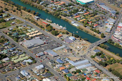
An aerial photograph of central Kaiapoi with the New World supermarket in the centre.

An aerial photograph of Manning Intermediate School, Hillmorton High School, and Spreydon School in Hoon Hay.

An aerial photograph of a residential area in Prebbleton.

Aerial image of Sumner taken by the Royal New Zealand Air Force for the Earthquake Commission.

Aerial image of Sumner taken by the Royal New Zealand Air Force for the Earthquake Commission.

Aerial image of New Brighton taken by the Royal New Zealand Air Force for the Earthquake Commission.

Aerial image of New Brighton taken by the Royal New Zealand Air Force for the Earthquake Commission.

Aerial image of Christchurch taken by the Royal New Zealand Air Force for the Earthquake Commission.

Aerial image of Lyttelton taken by the Royal New Zealand Air Force for the Earthquake Commission.

An aerial photograph of Central New Brighton School in New Brighton.

Aerial image of Porritt Park taken by the Royal New Zealand Air Force for the Earthquake Commission.

Aerial image of Porritt Park taken by the Royal New Zealand Air Force for the Earthquake Commission.

Aerial image of Porritt Park taken by the Royal New Zealand Air Force for the Earthquake Commission.

Aerial image of Christchurch taken by the Royal New Zealand Air Force for the Earthquake Commission.

Aerial image of Redcliffs taken by the Royal New Zealand Air Force for the Earthquake Commission.

Aerial image of Hagley Park taken by the Royal New Zealand Air Force for the Earthquake Commission.

Aerial image of Sumner taken by the Royal New Zealand Air Force for the Earthquake Commission.

Aerial image of Sumner taken by the Royal New Zealand Air Force for the Earthquake Commission.

An aerial photograph looking north-east looking across the Christchurch CBD with Cathedral Square in the centre left.

Aerial image of Porritt Park taken by the Royal New Zealand Air Force for the Earthquake Commission.