Search
found 896 results
QuakeStory Photo 330
Images, UC QuakeStudies
A photograph submitted by Bettina Evans to the QuakeStories website. The description reads, "Anglican Church ‘Trinity’, Winchester Street, Lyttelton, collapsed finally after June 23rd EQ".

Digital Photograph: Corner of London and Oxford Streets, Lyttelton
Images, Canterbury Museum
One landscape colour digital photograph taken on 19 November 2011 showing the site of the old Lyttelton Library, Council Chambers and Magistrates' Court on the corner of Oxford Street and Sumner Road. At the time of the 22 February 2011 Earthquake the building was in private ownership and was the premises of Moda Fotografica and a private resid...
Bettina Evans's photograph 103
Images, UC QuakeStudies
Woollen hats on the top of road cones out side Bill Hammond's house on Canterbury Street. Nobody knows who made these garments. They appeared overnight all over Lyttelton.

Digital Photograph: Earthquake damage to the Lyttelton Timeball Station.
Images, Canterbury Museum
One landscape colour digital photograph taken on 16 June 2011 showing the eastern skyline of Lyttelton without the tower of the Timeball Station and Signal Mast. Part of the ground floor remains visible. The Holcim Cement Silos and Lyttelton Port of Christchurch log storage yard are visible in the foreground. Photograph taken from Oxford Street...
Digital Photograph: Earthquake damage on corner of Canterbury and London S…
Images, Canterbury Museum
One landscape colour digital photograph taken on 25 February 2011 showing earthquake damage to the premises of Ground Delicatessen on the corner of Canterbury and London Streets. The photograph shows the building's Canterbury Street façade. This building was initially built around 1864 as the Albion Hotel. After many modifications and changes ...
Photograph of Gap Filler project 8 (10)
Images, UC QuakeStudies
Ryan Renolds building the petanque pitch at the Lyttleton Petanque Club.

Digital Photograph: Partially Demolished Shops, corner of London and Oxfor…
Images, Canterbury Museum
One landscape colour digital photograph taken on 14 September 2012 showing a block of partially demolished shops on the corner of London and Oxford Streets. The businesses (from left to right) are Bells Pharmacy, Leslie's Bookshop and Lyttelton Sea Foods. The site of The Empire Hotel is visible to the right of the photograph. By the time this p...

Digital Photograph: Earthquake damage to Church of the Most Holy Trinity, …
Images, Canterbury Museum
One landscape colour digital photograph taken on 15 June 2011 showing earthquake damage to the Anglican Church of The Most Holy Trinity in Winchester Street, Lyttelton. Photograph shows collapsed roof of the nave and north transept. Photograph taken from the north side of the church. Architect The collapse of the Church of the Most Holy Trinity ...

Digital Photograph: Earthquake damage to Church of the Most Holy Trinity, …
Images, Canterbury Museum
One landscape colour digital photograph taken on 15 June 2011 showing earthquake damage to the Anglican Church of The Most Holy Trinity in Winchester Street, Lyttelton. Photograph shows collapsed roof of the nave and north transept. Photograph taken from the northwest corner of the church. Architect The collapse of the Church of the Most Holy Tr...

Digital Photograph: Demolition of former Library and Fire Station, corner …
Images, Canterbury Museum
One landscape colour digital photograph taken on 6 September 2011 showing the demolition of 2 Sumner Road, the former library and fire station. This building was a private residence at the time of its demolition. Photograph taken looking north on Oxford Street. Also visible in the photograph are the Lyttelton Information Centre, an entrance to ...
Digital Photograph: Demolition of Coastal Living, London Street, Lyttelton
Images, Canterbury Museum
One portrait colour digital photograph taken on 15 April 2011 showing the demolition of Coastal Living Design Store on London Street. This photograph shows the building's flagpole being salvaged for the building owner during the demolition. Also visible are the stock and shop fittings which were unable to be retrieved. In Christchurch's Centra...

Digital Photograph: Earthquake Damage to Canterbury Hotel and shops. Oxfor…
Images, Canterbury Museum
One landscape colour digital photograph taken on 15 June 2011 showing earthquake damage to the former Canterbury Hotel and adjoining row of shops on Oxford Street. This photograph was taken on Oxford Street and shows the collapsed façade of the row of shops behind safety fencing, the interior of the building is exposed. Shadbolt House is visib...

Digital Photograph: Earthquake Damage to Canterbury Hotel and shops. Oxfor…
Images, Canterbury Museum
One landscape colour digital photograph taken on 15 June 2011 showing earthquake damage to the former Canterbury Hotel and adjoining row of shops on Oxford Street. This photograph was taken on Oxford Street and shows the collapsed façade of the row of shops behind safety fencing, the interior of the building is exposed. The design of many older...
QuakeStory Photo 325
Images, UC QuakeStudies
A photograph submitted by Bettina Evans to the QuakeStories website. The description reads, "A memorial blanket in creation, depicting some of the buildings lost in the earthquake in Lyttelton. Dozens of people are helping with the sewing – this is a follow on from the heart stitching which happened spontaneously in Lyttelton on London street after the February earthquake.".
New Zealand Defence Force photograph 146
Images, UC QuakeStudies
Defence Force personnel during an operational tour of Lyttelton taken by Commander Joint Forces New Zealand, Air Vice Marshal Peter Stockwell and Chief of Army Tim Keating to view the aftermath of the Christchurch Earthquake.
New Zealand Defence Force photograph 145
Images, UC QuakeStudies
Defence Force personnel during an operational tour of Lyttelton taken by Commander Joint Forces New Zealand, Air Vice Marshal Peter Stockwell and Chief of Army Tim Keating to view the aftermath of the Christchurch Earthquake.
New Zealand Defence Force photograph 147
Images, UC QuakeStudies
Defence Force personnel during an operational tour of Lyttelton taken by Commander Joint Forces New Zealand, Air Vice Marshal Peter Stockwell and Chief of Army Tim Keating to view the aftermath of the Christchurch Earthquake.
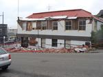
New Zealand Defence Force photograph 686
Images, UC QuakeStudies
The Ground Culinary Centre on the corner of London and Canterbury Streets. One of the side walls has crumbled, bricks lying on the footpath where they fell. Tape and cones have been used to create a cordon around the building.
QuakeStory Photo 354
Images, UC QuakeStudies
A photograph submitted by Bettina Evans to the QuakeStories website. The description reads, "The wrapped upstairs remnants of the Harbour Master’s Cafe, Lyttelton, cnr. Norwich Quay/Oxford Street, Sept. 2011.".
New Zealand Defence Force photograph 699
Images, UC QuakeStudies
The west side of the British Hotel on Oxford Street. The brick wall at the top of the building has crumbled onto the street below, bringing part of the roof down with it. Wire fencing has been used to create a cordon around the building.
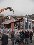
Bettina Evans's photograph 53
Images, UC QuakeStudies
The destruction of the Ground Culinary Centre on London Street. A digger is sitting on top of a pile of rubble. This site will soon be made into the Lyttelton Petanque Club.
Bettina Evans's photograph 72
Images, UC QuakeStudies
A cat curled up on a couch next to a cushion depicting a kiwi in a hard hat holding a shovel. The cushion was purchased at Lyttelton flea market in Oxford Street.
Bettina Evans's photograph 89
Images, UC QuakeStudies
The entrance way of the Lyttelton Convent (now privately owned) on Exeter Street, all that is left of this beautiful brick building. A pile of rubble can be seen through the doorway.
Bettina Evans's photograph 94
Images, UC QuakeStudies
A dinosaur seat on the corner of London and Oxford Streets, amongst flowers sown and tendered by children from Lyttelton Main School. In the background, the broken Plunkett Building can be seen.
Dino-Sauna Photograph 3
Images, UC QuakeStudies
A photograph of a sign giving information about the Gap Filler Dino-Sauna project.
New Zealand Defence Force photograph 685
Images, UC QuakeStudies
Damaged buildings along London Street. Wire fencing has been used to keep people away. From the left are the Volcano Cafe, the Lava Bar, a fish and chip shop, and the Coastal Living Design Store. Rubble from the side of the Volcano Cafe can be seen along the Canterbury Street footpath.
New Zealand Defence Force photograph 072
Images, UC QuakeStudies
Damage to Lyttelton following the 22 February 2011 earthquake. The fish and chip shop on London Street (centre) has a collapsed gable and awning. Bricks, plaster and wood are lying where they fell on the footpath, as well as the broken sign. To the left is the Lava Bar which suffered severe structural damage after the earthquake. To the right, the Coastal Living store can be seen which was open after the September earthquake but pulled down after February.
New Zealand Defence Force photograph 698
Images, UC QuakeStudies
Damage to the Fuze Restaurant and Cafe on the corner of Oxford Street and Norwich Quay. The facade around the top of the building has crumbled into the street below. Wire fencing has been used to create a cordon around the building.
Bettina Evans's photograph 93
Images, UC QuakeStudies
A carving in the Lyttelton Coffee Co, a boutique coffee roastery and cafe which was located in the converted historic butchery on London Street. The carving was made by the Whakaraupo Carving School
Upon the Upland Road Photograph 2
Images, UC QuakeStudies
A photograph of the installation 'Upon the Upland Road' on the former site of the Harbour Light in Lyttelton. The installation shows the last three lines of James K Baxter's poem, 'High Country Weather', written in the nautical flag alphabet.