
People look through the cordon fence at the badly damaged Stone Chamber of the Provincial Council Buildings. The photographer comments, "A bike ride around the CBD. Provincial Chambers, Durham St".

The intersection on the corner of Colombo and Bealey Avenue. In the background, the demolition site where the Bealey Pharmacy was. A damaged car sits on top of the pile of building rubble.

Detail of damage to a building on Ferry Road. The side walls have partially collapsed, and part of the brick wall is bowing outwards in danger of further collapse.

A snapshot from GPS Boomerang's SmartBird flight over the Christchurch red zone on 5 June 2012, looking over Cathedral Square with the Christchurch Cathedral, the Post Office Building and the Chalice visible.

Photograph captioned by BeckerFraserPhotos, "Intersection of Gloucester and Manchester Streets (north view)".

Members of the public walk past the damaged New Regent Street facades. The street has been cordoned off by security fences. The BNZ building on Armargh Street can be seen in the background.

A photograph captioned by BeckerFraserPhotos, "A view looking south west from the intersection of Manchester Street and Worcester Street".

Looking through the cordon fence from the vacant site from the demolition of St. John's Anglican Church on Latimer Square. The empty section it looks to is where CTV building use to be.

Photograph captioned by BeckerFraserPhotos, "Intersection of Gloucester and Manchester Streets (east view)".

Damage to a row of shops in Shirley. The parapets and awnings have collapsed, and the footpath is littered with rubble. The building has been cordoned off with police tape.

The intersection of Kilmore Street and Fitzgerald Ave. Damaged buildings in the background have been cordoned off with fencing and road cones. Plastic road barriers have been placed to divert the traffic.

Damage to the Cathedral of the Blessed Sacrament. Extensive damage can be seen on the north-west and south-west corners of the building, and cracking is visible underneath the dome.

The Caffe Roma coffee house on Oxford Terrace. Bricks from the facade above have fallen into the street and tape has been placed around the building as a cordon.

Building rubble behind cordon fencing at the corner of Salisbury and Montreal Streets. In the background is the Victoria Clock Tower, with the clock stopped at 12:51, the time of the 22 February earthquake.

An interior door exposed by the demolition of Henry Africa's. The photographer comments, "A building housing a restaurant and a great little neighbourhood bar is finally coming down because of earthquake damage. Demolition door".

University of Canterbury students walk along University Drive to get to lectures, after most pathways through campus were cordoned off while buildings were structurally tested. The photographer comments, "Lawns beside University Drive became main walkways".

Two badly damaged cars in an empty site on the corner of Tuam and Barbadoes Streets. In the background are the Hotel Grand Chancellor, the Holiday Inn City Centre, and the Westpac building.

A sign on the fence surrounding Knox Presbyterian Church reading, 'Broken but still beating. The heart of Christchurch is people like us!'.

Military personnel sit outside a security checkpoint tent. In the background, the stone cladding of a gable end on the Cranmer Courts building has collapsed, exposing the wooden framework beneath.

People walk past the cordon fence beside the badly damaged Stone Chamber of the Provincial Council Buildings. The photographer comments, "A bike ride around the CBD. Provincial Chambers, Durham St".

People walk past the cordon fence beside the badly damaged Stone Chamber of the Provincial Council Buildings. The photographer comments, "A bike ride around the CBD. Provincial Chambers, Durham St".

A member of the University of Canterbury's E-Learning team, Jessica Hollis, in their new office in the James Hight building. The photographer comments, " Jess Hollis settles in to her new workspace".

Damage to Asko Design store and Mod's Hairdressing on Victoria Street. Road fencing and cones have been put up to contain the building rubble which has spilled onto the footpath and road.

The three-storey masonry building which housed the Ruben Blades Hairdressing Academy, and the Honey Pot Caf_. Fencing and road cones have been placed along the footpath to keep the public away.

A damaged building on Manchester Street. Fencing and road cones have been placed in front to keep the public away. A row of motorbikes are parked on the side of the road.

The damaged Carlton Hotel with scaffolding on one side supporting the walls. On the other side, the wall has crumbled, exposing the interior, and leaving a pile of building rubble on the footpath.

Spray painted codes outside a block of apartments after it had been cleared by a USAR team. This system was used following the February earthquake to mark buildings that have been checked.
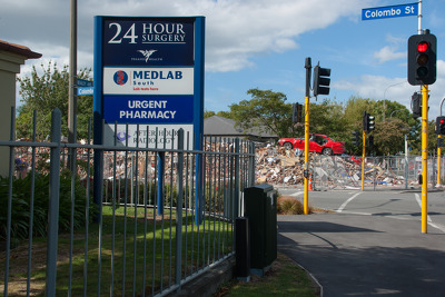
The intersection on the corner of Colombo and Bealey Avenue. In the background, the demolition site where the Bealey Pharmacy was. A damaged car sits on top of the pile of building rubble.

The building that housed the New Zealand College of Early Childhood Education and Antiqueworld has been cordoned off. Spray painted marks left by USAR after it was checked can still be seen.

A snapshot from GPS Boomerang's SmartBird flight over the Christchurch red zone on 23 December 2012, looking over Hereford Street with the BNZ Building almost demolished in the centre left.