
One landscape colour digital photograph taken on 25 February 2011 showing earthquake damage to the Presbyterian Church of St John in Winchester Street Lyttelton. Photograph shows the main doors, roof and collapsed tower at southern end of church. Architect St John's Lyttelton was one of the oldest Presbyterian Churches in Canterbury. The New Ze...

One landscape colour digital photograph taken on 11 May 2011 showing the town of Lyttelton looking north from the footpath of the Oxford Street Over bridge. The Lyttelton streetscape has changed dramatically from its pre-earthquake appearance and will continue to change as new buildings are erected on empty sections. In this photograph the dome...

One landscape colour digital photograph taken on 15 June 2011 showing earthquake damage to the Presbyterian Church of St John in Winchester Street, Lyttelton. Photograph shows the collapsed roof and tower. The photograph is taken from the southeast corner of the church. Architect St John's Lyttelton was one of the oldest Presbyterian Churches in...

Photograph captioned by BeckerFraserPhotos, "Corner London, Oxford Streets".

A photograph captioned by BeckerFraserPhotos, "Overlooking the Port of Lyttelton".

Volunteers building the petanque pitch at the Lyttelton Petanque Club.

Volunteers building the petanque pitch at the Lyttelton Petanque Club.

Ryan Renolds from Gap Filler at the Lyttelton Petanque Club.

Volunteers constructing the petanque pitch at the Lyttelton Petanque Club.

A photograph captioned by BeckerFraserPhotos, "Holy Trinity Anglican Church in Lyttelton".

Volunteers building the petanque pitch at the Lyttelton Petanque Club.

A photograph of a damaged building. The photograph is captioned by BeckerFraserPhotos, "Norwich Quay, Lyttelton".

A photograph captioned by BeckerFraserPhotos, "The site of 'Ground' and Tunnel Vision Backpackers in Lyttelton".

One landscape colour digital photograph taken on 27 May 2013 of London Street in Lyttelton. Taken from Sumner Road looking west across the intersection of London and Oxford Streets. The photograph shows several empty sections and the remaining buildings. The Lyttelton streetscape has changed dramatically from its pre-earthquake appearance and w...

One landscape colour digital photograph taken on 19 November 2011 showing buildings on London Street. Visible in the photograph (left to right) are Lyttelton Ambulance Station and Bells Pharmacy - relocated into a converted house with law firm MacTodd on the upper floor. Discussions have been held between Lyttelton Police, St John Ambulance and...

Photos taken in Lyttelton following the February 22 earthquake.
File ref: CCL-2011-03-05-After-The-Earthquake-P1110551
From the collection of Christchurch City Libraries

Photos taken in Lyttelton following the February 22 earthquake.
File ref: CCL-2011-03-05-After-The-Earthquake-P1110470
From the collection of Christchurch City Libraries

Photos taken in Lyttelton following the February 22 earthquake.
File ref: CCL-2011-03-05-After-The-Earthquake-P1110472
From the collection of Christchurch City Libraries

Damage to Lyttelton following the 22 February 2011 earthquake. St John's Church on Winchester Street with a collapsed spire and rubble lying on the footpath where it fell.

A view across Canterbury Street in Lyttelton to The Volcano Cafe and The Lava Bar. Masonry from the buildings has collapsed onto the footpath, and the site has been cordoned off by a safety fence.

The Empire Hotel on London Street in Lyttelton. Bracing has been placed on the front of the building to keep it together and limit further damage from aftershocks. The building has been cordoned off with fencing.

A photograph of residents walking down London Street in Lyttelton. In the background, the earthquake damage to the Ground Culinary Centre can be seen as well as a number of cordon fences.

A photograph captioned by BeckerFraserPhotos, "A demolition site on the corner of Oxford Street and Sumner Road. The area is given a Lyttelton-style makeover with wild flowers and triceratops".

Demolition of the top storey of Fuze Restaurant and Cafe. The building formerly housed the Harbour Board Offices, and was built in 1880.

A photograph captioned by BeckerFraserPhotos, "A new bar, the 'Port Hole', on the side of the Volcano Cafe on London Street. The bar is almost ready for opening the next day. Workers are enjoying an after work drink".
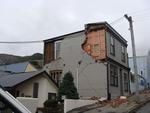
One landscape colour digital photograph taken on 25 February 2011 showing earthquake damage to houses on the western side of Canterbury Street between London and Winchester Streets. The photograph shows large sections of a brick firewall which have fallen onto the roof of the neighbouring house. The close proximity of buildings in Lyttelton led...

A digger and two workers on top of demolition rubble from the Volcano Cafe and Lava Bar on London Street in Lyttelton.

A digger and two workers on top of demolition rubble from the Volcano Cafe and Lava Bar on London Street in Lyttelton.

A digger and two workers on top of demolition rubble from the Volcano Cafe and Lava Bar on London Street in Lyttelton.
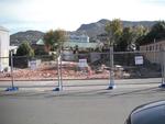
One landscape colour digital photograph taken on 12 April 2011 showing the site of the Norton Buildings and Lyttelton Lounge on Oxford Street. Architect The buildings on this site were severely damaged and demolished within days of the 22 February 2011 earthquake. The larger of the two properties in this photograph was the site of the 1913 Norto...