
Looking down High Street from Colombo Street. A public walkway down Colombo Street to a small viewing area in the Square was opened up for a few weekends to allow the public to see inside the Red Zone.

Looking down High Street from Colombo Street. A public walkway down Colombo Street to a small viewing area in the Square was opened up for a few weekends to allow the public to see inside the Red Zone.

Looking down High Street from Colombo Street. A public walkway down Colombo Street to a small viewing area in the Square was opened up for a few weekends to allow the public to see inside the Red Zone.

A snapshot from GPS Boomerang's SmartBird flight over the Christchurch red zone on 23 December 2012, looking over Victoria Square with the Forsyth Barr Building and the Victoria Apartments visible. The PriceWaterHouseCoopers Building has been demolished.
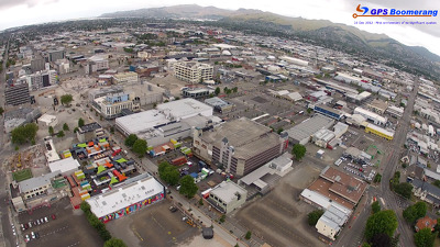
A snapshot from GPS Boomerang's SmartBird flight over the Christchurch red zone on 23 December 2012, looking over Cashel Street where the Re:Start container mall now sits. The Holiday Inn and Westpac Trust Building have been demolished.
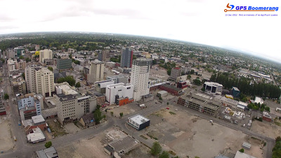
A snapshot from GPS Boomerang's SmartBird flight over the Christchurch red zone on 23 December 2012, looking over Worcester Street with the Rendezvous Hotel visible in the middle and the Octagon Live Restaurant below. The Newstalk ZB Building has been demolished.

A snapshot from GPS Boomerang's SmartBird flight over the Christchurch red zone on 23 December 2012, looking over Gloucester Street with the Cathedral visible on the bottom left and Oxford Terrace to the right. Clarendon Towers has been demolished.
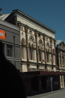
For the first time in November 2011, Christchurch residents finally had the opportunity to see the earthquake-damaged city centre on the Red Zone bus tours organised by CERA. Damage to the Odeon Theatre can be seen out the window.
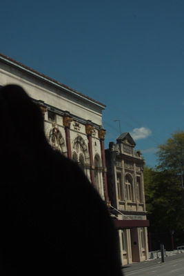
For the first time in November 2011, Christchurch residents finally had the opportunity to see the earthquake-damaged city centre on the Red Zone bus tours organised by CERA. Damage to the Odeon Theatre can be seen out the window.

For the first time in November 2011, Christchurch residents finally had the opportunity to see the earthquake-damaged city centre on the Red Zone bus tours organised by CERA. Damage to buildings on Cashel Street can be seen out the window.

For the first time in November 2011, Christchurch residents finally had the opportunity to see the earthquake-damaged city centre on the Red Zone bus tours organised by CERA. The Regent Theatre dome which has been removed from the building.

For the first time in November 2011, Christchurch residents finally had the opportunity to see the earthquake-damaged city centre on the Red Zone bus tours organised by CERA. Looking into Cathedral Square, the Regent Theatre dome can be partially seen.

A public walkway down Colombo Street to a viewing area in the Cathedral Square was opened up for a few weekends to allow the public to see inside the Red Zone. The Chalice sculpture and the Cathedral in Cathedral Square.

Damage to the Cathedral, and its lawn growing wild. A public walkway through to a small viewing area in the Square was opened up for a few weekends to allow the public to see inside the Red Zone.

A chimpanzee paints with a palette of colours. Context: After the earthquakes in Christchurch buildings and areas were designated green, blue, red or white depending on the degree of damage. Buildings in the 'red' zone were then examined to ascertain whether they should be demolished or restored and sometimes the land itself was deemed unsafe. There have been many controversial decisions made which is the point the cartoon makes.
Quantity: 1 digital cartoon(s).

A photograph captioned by BeckerFraserPhotos, "A view from Worcester Street. A gap has been left by the demolition of the Press building, allowing a view of the Copthorne Christchurch Central Hotel".

A photograph of liquefaction along the footpath in front of St Paul's Church on Gayhurst Road. The church was severely damaged during the 4 September earthquake. Tape has been placed around the building to warn people off.

A photograph of the house at 466 Oxford Terrace. The house number has been spray-painted on one of the windows. Wire fencing has been placed across the front of the property as a cordon.

A photograph of large cracks in the pavement in front of St Paul's School in Dallington. Liquefaction silt can also be seen. Police tape has been draped across the entrance of the building to the left.

A photograph looking through the door of the front room in Donna Allfrey's house at 406 Oxford Terrace to the lounge and kitchen. A bed has been placed in the middle of the lounge.

Liquefaction and flooding in Waitaki Street, Bexley. The photographer comments, "Waitaki Street a week after the Christchurch Earthquake. Because of the damage to the drains and liquefaction in the area the streets are not drying out".

A photograph of Robin Duff's house at 386 Oxford Terrace. Plastic sheeting has been placed over sections of the house to keep it water tight.

Photograph captioned by BeckerFraserPhotos, "High Street with the remains of the Hotel Grand Chancellor and the Holiday Inn and Westpac building (both under demolition). Manchester Street on the left".

A photograph of Donna Allfrey's house at 406 Oxford Terrace. A green sticker on the front door indicates that the house has been inspected and it is safe to enter.

A photograph of Doug Sexton's garden at 378 Oxford Terrace, now overgrown. In the background is his partially-demolished garage. The photographer comments, "Sexton's garden was once published in Small Gardens".

A photograph of Donna Allfrey's house at 406 Oxford Terrace. A green sticker on the front door indicates that the house has been inspected and it is safe to enter.

A photograph of the hallway of Donna Allfrey's house at 406 Oxford Terrace. To the right, a couch has been upturned and placed against a mantelpiece in one of the rooms.

Photograph captioned by BeckerFraserPhotos, "St John the Baptist in Latimer Square - with a clear view of the church and the hall now that the Arrow building is demolished".

In what used to be sections with houses and yards. Between late 2011 and 2014 the houses (well 95% of them) were removed due to land dropping in the 2011 earthquakes and the proximity of the Avon River, tidal in this area.

All this is "red zone" after the earthquakes and has to be demolished. The roof of my "old" house (now owned by the government) can be seen between the third and fourth river-side houses.