
A digitally manipulated photograph of a building on Poplar Lane. The photographer comments, "I felt that this building had a real Italian feel about it. It is actually in Christchurch, New Zealand. It appears on the list to be partially demolished after the Christchurch earthquake, so it might not be around for much longer".

An old advertising sign exposed by the demolition of an adjoining building. The photographer comments, "'Protect your investment. Paint your property regularly - and save money. Polson's decorators and sign writers.' The building that was adjacent to this one was demolished after the Christchurch earthquake and revealed this fabulous old wall sign.

Two cardboard coffee cups in a takeaway tray sit on a wooden counter. The photographer comments, "What is the story of these coffees and that sad muffin? Were these an order when the earthquake struck Christchurch on 22 February 2011? Were these a workman's and a colleague's having a quick coffee break when a later aftershock caused them to leave everything behind when they fled the red zoned building, or were they just forgotten when the building was cleared out and abandoned?".

Photograph captioned by BeckerFraserPhotos, "The new Press building on Gloucester Street at dusk. The central city red zone now has office workers and lights on".

Photograph captioned by BeckerFraserPhotos, "The lights are on at the new Press building, the first office workers to return to the central city red zone".
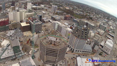
A snapshot from GPS Boomerang's SmartBird flight over the Christchurch red zone on 5 June 2012, looking over the Westpac Trust Building towards the Holiday Inn.

Photograph captioned by BeckerFraserPhotos, "207-211 Cashel Street. All buildings demolished including the CTV building (behind the digger). Latimer Square in the background".

Sandbags placed along the river bank to prevent flooding onto the road. The earthquake caused the ground in this area to subside , making it susceptible to flooding.

A view down the High Street Mall from Cashel Street, looking towards the Port Hills. Rubble from a collapsed building is visible on the right.

Photograph captioned by BeckerFraserPhotos, "The view from the top of Alice in Videoland".

Photograph captioned by BeckerFraserPhotos, "The view from the top of Alice in Videoland".

A photograph looking down the Avon River to the house at 2 Bangor Street.

Phil Goff leading the Stronger Christchurch Infrastructure Rebuild Team (SCIRT) as they are welcomed by a powhiri. The ceremony was held in Burwood Park.

A Ngai Tahu elder presents to politicians and the Stronger Christchurch Infrastructure Rebuild Team (SCIRT). The ceremony was held in Burwood Park.

Photograph captioned by BeckerFraserPhotos, "View towards Provincial Council Chamber roof in Durham Street taken from Oxford Terrace".

Photograph captioned by BeckerFraserPhotos, "View towards Provincial Council Chamber roof in Durham Street taken from Oxford Terrace".

Photograph captioned by BeckerFraserPhotos, "Working on cleaning up food places, a malodourous occupation. Corner of Armagh and Colombo Streets".

Photograph captioned by BeckerFraserPhotos, "Octagon Live restaurant, old Trinity Congregational Church, corner of Worcester and Manchester Streets".

Photograph captioned by BeckerFraserPhotos, "Octagon Live restaurant, (formerly Trinity Congregational Church), corner of Worcester and Manchester Streets".

Photograph captioned by BeckerFraserPhotos, "Octagon Live restaurant, old Trinity Congregational Church, corner of Worcester and Manchester Streets".

Photograph captioned by BeckerFraserPhotos, "Octagon Live restaurant, old Trinity Congregational Church, corner of Worcester and Manchester Streets".

Photograph captioned by BeckerFraserPhotos, "Oran and Waitaki Streets, Bexley".

A photograph submitted by Sarndra to the QuakeStories website. The description reads, "Piles of silt for removal, Niven Street, Avondale [red zone section]. Approx 29 February 2011.".

A man takes a photograph over the top of the cordon fence by the viewing windows into the Red Zone at the east end of the Re:Start mall.

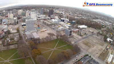
A snapshot from GPS Boomerang's SmartBird flight over the Christchurch red zone on 5 June 2012, looking over Bedford Row with Latimer Square in the distance to the left.
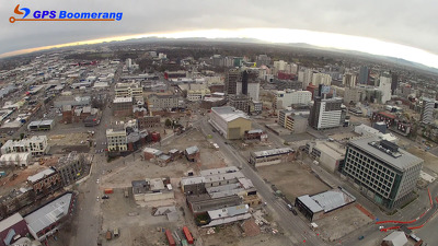
A snapshot from GPS Boomerang's SmartBird flight over the Christchurch red zone on 5 June 2012, looking over Latimer Square with the CTV Building site visible on the right.
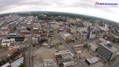
A snapshot from GPS Boomerang's SmartBird flight over the Christchurch red zone on 5 June 2012, looking over High Street with the front of Alice in Videoland visible.

A snapshot from GPS Boomerang's SmartBird flight over the Christchurch red zone on 23 December 2012, looking over Latimer Square with the CTV Building site visible on the right.

A snapshot from GPS Boomerang's SmartBird flight over the Christchurch red zone on 23 December 2012, looking over Madras Street with the High Street shops in the bottom left.
A snapshot from GPS Boomerang's SmartBird flight over the Christchurch red zone on 23 December 2012, looking over High Street with the front of Alice in Videoland visible.