
A "Welcome to Christchurch" sign on the cordon fence near the Re:Start mall provides a map of the red zone and information for tourists.

A view into the Red Zone from Colombo Street, looking through cordon fencing. Some shipping containers and diggers can be partially seen in the background.
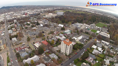
A snapshot from GPS Boomerang's SmartBird flight over the Christchurch red zone on 5 June 2012, looking over the Arts Centre with Christ's College to the right.

A photograph of a building on Manchester Street.

A photograph of a sign on a house reading, "Red zone, yeah right". The photograph is captioned by BeckerFraserPhotos, "Featherston Avenue, Pines Beach".

Student Volunteer Army members enjoying a barbeque lunch break in Burwood Park after clearing liquefaction from properties in the area.

Student Volunteer Army members enjoying a barbeque lunch break in Burwood Park after clearing liquefaction from properties in the area.

Student Volunteer Army members enjoying a barbeque lunch break in Burwood Park after clearing liquefaction from properties in the area.

Student Volunteer Army members enjoying a barbeque lunch break in Burwood Park after clearing liquefaction from properties in the area.

A photograph of the front gate of Robin Duff's house at 386 Oxford Terrace.

A photograph of the site of Donna Allfrey's demolished house at 406 Oxford Terrace.

Photograph captioned by BeckerFraserPhotos, "641 Colombo Street - Benson Restaurant No 1".

A photograph looking north down Gayhurst Road, taken from the side of the bridge over the Avon River. Residential properties used to line the left-hand side of the road, and St Paul's church once stood on the corner. This was before the land was red-zoned as a result of the 2010 and 2011 Canterbury earthquakes. Separated cycle ways have recently been installed on both sides of the road. The photograph was modelled off an image taken by Mark Lincoln in September 2010.

A photograph looking north down Gayhurst Road, taken from the side of the bridge over the Avon River. Residential properties used to line the left-hand side of the road, and St Paul's church once stood on the corner. This was before the land was red-zoned as a result of the 2010 and 2011 Canterbury earthquakes. Separated cycle ways have recently been installed on both sides of the road. The photograph was modelled off an image taken by Mark Lincoln in September 2010.

A photograph looking north down Gayhurst Road, taken from the side of the bridge over the Avon River. Residential properties used to line the left-hand side of the road, and St Paul's church once stood on the corner. This was before the land was red-zoned as a result of the 2010 and 2011 Canterbury earthquakes. Separated cycle ways have recently been installed on both sides of the road. The photograph was modelled off an image taken by Mark Lincoln in September 2010.
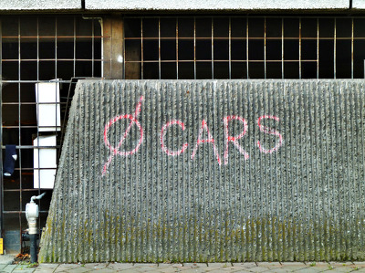
Spray-painted writing on the side of a car parking building reads "0 cars". The photographer comments, "Strangely and appropriately this graffiti was on a car park. In fact the graffiti was 100% correct as the car park is in the Christchurch earthquake red zone and there should be zero cars now inside it. It may have been put on by an anti car protester or just an indication that the car park is empty. One of the suggestions for the City plan for the rebuilt Christchurch was for a pedestrian and cycle only area, which also fits in with 0 CARS".

A laminated sign for the 2011 Festival of Flowers attached to a wooden planter. The plants in the planter are dry and dead. The photographer comments, "The theme for the 2011 Festival of Flowers was 'burst! of water'. The Christchurch February earthquake came and water and sand called liquefaction burst out of the ground all around the area. Ironically the plants for the festival were left unattended in the cordoned off red zone and they would have loved a little burst of water".

Football turf has now gone and the area fenced off again.

20130911_8095_EOS M-33 Another one ready to leave
Another salvaged house from the Bexley (Pacific Park) red zone is on the truck and may start it's journey to a new location overnight.
#4204

8 Velsheda Street, Bexley, Christchurch, across the road from my house was demolished a week or so ago, just one of many demolitions of Red Zone properties at the moment. This house was about ten years old and suffered land damage during the 4th September 2010 and 22nd February 2011 earthquakes.
The same fate awaits my house later in the year o...

A photograph of the house at 428 Oxford Terrace. Plywood has been placed over the door. The house number has been spray-painted on the plywood.

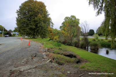
A photograph captioned by BeckerFraserPhotos, "A mound of liquefaction next to an angled street light on Liggins Street in the Horseshoe Lake area".

A couple in a red-zoned dog kennel, completing the dwelling census. Their accommodation has one room;, their only heating is by body heat and burning furniture; their rent is $1000 per week.
Two years after the earthquakes, the living conditions of many in the 'red zones' of Christchurch was poor, owing to local body, government and insurance companies' tardiness.
Quantity: 1 digital cartoon(s).

Photograph captioned by BeckerFraserPhotos, "This container is placed vertically against the building and filled with debris - Madras Street".

A photograph of the earthquake damage to St Paul's Church on Gayhurst Road. The tiles towards the back of the building have lifted.
Photograph captioned by BeckerFraserPhotos, "Oxford Terrace in the Avon Loop area showing the lateral spread on the river banks".

A photograph captioned by BeckerFraserPhotos, "A view looking across the Avon River from Avonside Drive to Dallington Terrace".

A photograph captioned by BeckerFraserPhotos, "A view looking north west from the intersection of Manchester Street and Worcester Street".

A photograph captioned by BeckerFraserPhotos, "A view looking west from the intersection of Manchester Street and Worcester Street, towards Cathedral Square".

A photograph of the house at 410 Oxford Terrace. The grass has been mowed but the dead grass has not been removed.