
An infographic showing planned changes to transport in the central city.

A graphic illustrating the findings of the Royal Commission enquiry into the CTV building collapse.

A map showing proposed public transport routes in the central city.

A graphic giving details about the river park proposed in the Christchurch Central Recovery Plan.

A map showing the locations of property developments around Christchurch.

A page layout for a feature titled, "The land report".

An infographic illustrating an accountability scorecard given to CERA.

A page banner which is part of a series of banners about earthquake-related articles.

A cartoon about the wait for land reports.
An infographic describing the 13 June 2011 earthquakes.

A map showing the location of a walkway to Cathedral Square.

A compilation of photographs of notable entranceways to cities and towns.

A logo for a 'Back in business' feature.

A page banner which is part of a series of banners about earthquake-related articles.

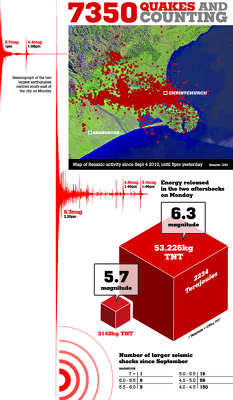
A map showing the locations and magnitudes of aftershocks.

A graphic promoting a video about the Ballantynes sale.

A graph showing the result of an online poll which asked Christchurch residents, "Would you leave Christchurch if you could?".

A map which was used to illustrate an Ask the Expert feature, showing the locations of aftershocks and fault lines.

A map showing the location of a proposed subdivision.

A page banner promoting an article about Christchurch Central Development Unit director Warwick Isaacs.

A page banner promoting an article about visitors avoiding the South Island.

An advertisement for the "Fight for Christchurch" event.

A graphic giving information on rates increases in Christchurch.

A map showing likely residential land availability in the Eastern Waimakariri district.

A map showing the locations of businesses on the edge of the red zone.

A list of newly released casualities of the 22 February 2011 earthquake.

A map showing the locations of fatalities from the 22 February 2011 earthquake.

A list of newly released casualities of the 22 February 2011 earthquake.

The front page graphic for the Mainlander section of The Press, listing earthquake-related articles.

A map showing the location and magnitude of aftershocks.