
One landscape colour digital photograph taken on 6 September 2010 showing earthquake damage to buildings on Victoria Street near Bealey Avenue. The red brick building is the Knox Church; it still stands on the corner of Bealey Avenue and Victoria Street following the earthquake, though some extreme measures were taken to make it safe. The red b...

One landscape colour digital photograph taken on 6 September 2010 showing earthquake damage to the red brick building of the Christchurch Chinese Methodist Church, 165 Papanui Road. The Christchurch Chinese Methodist Church on Papanui Road sustained severe damage during the 4 September 2010 earthquake. The red placards placed on the door of the...

One landscape colour digital photograph taken on 6 September 2010 showing earthquake damage and a red placard on the red brick building of the Christchurch Chinese Methodist Church, 165 Papanui Road. The Christchurch Chinese Methodist Church on Papanui Road sustained severe damage during the 4 September 2010 earthquake. The red placards placed ...

One landscape colour digital photograph taken on 27 April 2011 showing damage to the London Street Restaurant. Photograph taken looking west from the intersection of London Street with Oxford Street and Sumner Road. Adaptability and quick thinking has become a key part of business survival in post earthquake Canterbury. The owner of this bui...

One landscape colour digital photograph taken on 15 June 2011 showing earthquake damage to the Presbyterian Church of St John in Winchester Street, Lyttelton. Photograph shows the collapsed roof and tower. The photograph is taken from the southeast corner of the church. Architect St John's Lyttelton was one of the oldest Presbyterian Churches in...

Colombo Street, looking north from Cathedral Square

Kilmore Street looking west from Manchester Street

Roy Stokes Hall New Brighton - Welfare Distribution Centre

Structural engineers inspecting the Warners Novotel, Cathedral Square.

A photograph of a veterinarian and animal attendant at SPCA Canterbury after the 22 February 2011 earthquake.
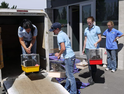
A photograph of members of the SPCA preparing cats for relocation after the 22 February 2011 earthquake.

Photo of earthquake damage on Double Days Road taken by Kate Roughan, 8 September 2010.

Liquefaction and flooding in a street in Kaiapoi, after the September 4th earthquake.

Cracks and liquefaction on a street in Avonside after the September 4th earthquake.

Cracks and liquefaction on a street in Avonside after the September 4th earthquake.

Cracks in the street and footpath in Avonside after the September 4th earthquake.

Liquefaction and flooding in a park in Kaiapoi after the September 4th earthquake.

Cracks across Reid Memorial Avenue in Pines Beach after the September 4th earthquake.

Liquefaction and flooding in a park in Kaiapoi after the September 4th earthquake.

Flooding and liquefaction in Hood Avenue, Pines Beach, after the September 4th earthquake.

Liquefaction in front of a store in Kaiapoi, after the September 4th earthquake.

Liquefaction around a power pole in Pines Beach, after the September 4th earthquake.

An image from a Navy Today April 2011 article titled, "Earthquake!". The image is of the Time Ball Station in Lyttelton, photographed from the HMNZS Canterbury in the Lyttelton Harbour.

The corner of Saint Asaph Street and Colombo Street.

The corner of Saint Asaph Street and Barbadoes Street.
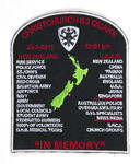
One black, red and white plastic-backed fabric uniform badge commemorating the 22 February 2011 earthquake; the words 'Christchurch 6.3 Quake' are embroidered in red along the top along with '22-2-2011' and '12.51pm'; Along the bottom are the words 'In Memory'; In the centre is a map of New Zealand in green with a red embroidered star over Cante...
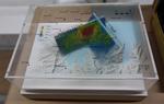
One oblong perspex covered 3-D model of the fault plains that ruptured to cause the 22 February and 13 June 2011 earthquakes; top of the model also acts as a map overlay. This model provides a visual demonstration of the geological forces that caused the 22 February and 13 June 2011 earthquakes. These forces were so strong that parts of the Por...

One six-wheeled Rover 3 remote controlled vehicle in hard-shell storage box and one handset control unit (transmitter), colour monitor with cabling (and A/V receiver) and three batteries in a second smaller hard-shell storage box.

One landscape colour digital photograph taken on 9 March 2011 showing earthquake damage to the Lyttelton Coffee Company Building on London Street. The photograph shows a fenced off section of the south side of London Street. Also visible in the photograph are the Lyttelton Four Square, and the gateway leading to the Wunderbar. Due to prior eart...

One landscape colour digital photograph taken on 12 April 2011 showing earthquake damage to the former Convent of Our Lady of Mercy. St Mary's School, run by the Sisters of Mercy, was also housed in this building. At the time of the 4 September 2010 earthquake the building was a private residence. The sense of loss felt when confronted with the...