
A map showing the location of proposed subdivisions.

A map showing the location of heritage buildings.

A map showing the location of the Faringdon subdivision.

A map showing the location of historic Christchurch earthquakes.

A map showing earthquake-prone buildings in Selwyn district.

A map showing the location of TC3 land.

A map showing the locations and magnitudes of aftershocks.

A map showing the location of a proposed subdivision.

A map showing the location and magnitude of aftershocks.

A LIDAR map showing traces of the Alpine Fault.

A map showing the location of a proposed development.

A map showing the location of a proposed subdivision.

A map showing the location of a building site.

A map showing the location of tsunami warning systems.

A map showing the epicentre of a large aftershock.

A map showing closed roads in the city centre.

A map showing the status of housing in Kaiapoi.

A map showing the locations and magnitudes of aftershocks.

A map showing the location of the Bridgewater Apartments.

A map showing the location of damaged public artworks.

A map showing the location of courts in Canterbury.

A map showing the location and magnitude of aftershocks.
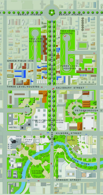
A map showing details of the Central City Plan.

A map showing the location and magnitude of aftershocks.

A map showing the locations of businesses in Sydenham.

A map showing the location of Holy Trinity Church.

A map showing proposed light rail routes in Christchurch.

A map showing road closures in the central city.

A map showing road closures in the central city.

A map showing the route for the Christchurch Marathon.