
A photograph of the earthquake damage to St Paul's Church on Gayhurst Road. The tiles towards the back of the building have lifted.

A photograph of a painted sign on 448 Colombo Street, exposed after the brick wall which covered it was damaged by an earthquake.

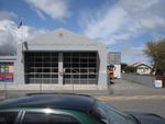
Photograph captioned by Fairfax, "Day after the earthquake that rocked Christchurch. Damage to the road frontage in front of the Kaiapoi Fire Station".

A photograph of a painted sign on 448 Colombo Street, exposed after the brick wall which covered it was damaged by an earthquake.

A photograph of a message on the side of an earthquake-damaged building. The message reads, "Clear. Smell is seafood - confirmed 4 March".

Photograph captioned by Fairfax, "Murray Rowlands and Carly Sluys from Federated Farmers look at damaged grain silos west of Burnham after Saturday's earthquake".

None

None

The EQC (Earthquake Commission) has developed new standards and designs to help rebuild Christchurch after the earthquakes of 2010 and 2011. The Department of Building and Housing have produced some generic building foundation and floor designs that can be used for residential homes being built or repaired on liquefied, tilting, unsettled and/or damaged land. (RebuildChristchurch.co.nz)
Quantity: 1 digital cartoon(s).

A photograph of a yellow sticker on the window of the Diabetes Centre on Hagley Avenue. The sticker was placed on the building after the 4 September 2010 earthquake, indicating that access to the building was restricted. The engineer who surveyed the building describes the damage to the building as follows: "Panel damaged and displaced at rear - area cordoned off. Loose soffit linings. Damage to ceiling".

Damage to River Road in Richmond. The road surface is badly cracked and slumped, and liquefaction silt covers part of the road. Two people in gumboots walk towards a barrier erected across the road using road cones and warning tape, and in the background the badly twisted Medway Street bridge can be seen. The photographer comments, "Longitudinal cracks indicate lateral movement as the land sagged towards the river. Near 373 River Rd, looking south-east towards Medway St. The Medway St bridge is visible in the background".

Damage to the garden of a house in Richmond. Liquefaction is visible among the plants and on the driveway, and the driveway is badly cracked. The photographer comments, "These photos show our old house in River Rd. Water and silt have flattened the long grass in the back garden. The growth right of centre is suckers growing from the stump of a prunus tree we had felled last year. The section of fence between us and our neighbour fell down in the Sep 4 quake".

Detail of damage to a house in Richmond. A double-brick wall has collapsed, and a gap is visible between the house and its foundation. The photographer comments, "These photos show our old house in River Rd and recovery work around Richmond and St Albans. The house and the concrete patio are now 15cm apart. The house took half the dining room's remaining bricks with it as it jumped off the foundations. It gives a good visual indication of the displacement".

Damage to a residential property in Richmond. The brick wall of the garage has collapse inward, and the roof fallen in on top of it. The photographer comments, "These photos show our old house in River Rd and recovery work around Richmond and St Albans. The neighbours behind us used the kayak to get in to their house - it's flooded by Dudley Creek which runs behind the block, plus major liquefaction. Our old garage provides a good spot to park it".

Detail of damage to a house in Richmond. A double-brick wall has collapsed. A wire loop which formerly tied the two layers of bricks together has pulled out from one of the layers, showing how the two parts of the wall moved apart during the shaking. The photographer comments, "These photos show our old house in River Rd and recovery work around Richmond and St Albans. The remaining double brick by the back door has been further smashed and twisted".
One landscape colour digital photograph taken on 19 November 2011 showing the Lyttelton Fire Station. The building is fenced off and unused due to earthquake damage. To the right of the photograph the front of one of the Fire Appliances and the shipping containers set up in the rear car park to provide temporary facilities can be seen. Followin...

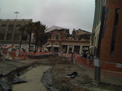
A photograph of the earthquake damage to Winnie Bagoes on Colombo Street. The closest section of the building has collapsed, the bricks spilling onto the footpath and damaging the awning. Wire fencing has been placed around the footpath as a cordon.

A photograph of the earthquake damage to Cranmer Courts on the corner of Montreal and Kilmore Streets. The brick walls of the gables have crumbled at the top, and wooden bracing has been placed against them to limit further damage.

A digitally manipulated image of two stained glass windows. The photographer comments, "This is an abstract of the stained glass window of St Peter's Church in Christchurch, New Zealand. The church was seriously damaged in the Christchurch earthquake".
A photograph of the earthquake damage to the Domo furniture store on Tuam Street taken shortly after the 22 February 2011 earthquake. A group of people can be seen walking past the Alice in Videoland building to the right.

A photograph of the earthquake damage to the Domo furniture store on Tuam Street taken shortly after the 22 February 2011 earthquake. A group of people can be seen walking past the Alice in Videoland building to the right.

A digitally manipulated image of a broken window. The photographer comments, "There is hardly anything left of Christchurch's proud heritage buildings. Most older buildings were made of brick and though they should have had improvements to make them withstand a medium earthquake most did not. They were badly damaged when hit with a series of earthquakes that were up to 2.2g at the epicentre and 1.88g in the City".

A local resident walks to the nearest dairy for essentials after the 7.1 magnitude quake, that has caused major infrastructure damage to Christchurch City.

The cross at the top of the Cathedral of the Blessed Sacrament, knocked off kilter by the earthquake.

This building at the corner of Barbadoes Street / St Asaph Street was so badly damaged in the magnitude 7.1 earthquake that struck Christchurch on Saturday 4 September 2010 that it had to be demolished

The damaged Provincial Council Legislative Chamber on Durham Street in the aftermath of the 22 February 2011 earthquake. The building's roof and walls have collapsed, as has the scaffolding which was erected to repair it after the 4 September 2010 earthquake.

The damaged Provincial Council Legislative Chamber on Durham Street in the aftermath of the 22 February 2011 earthquake. The building's roof and walls have collapsed, as has the scaffolding which was erected to repair it after the 4 September 2010 earthquake.

Photograph captioned by Fairfax, "Christchurch Earthquake. A massive 7.4 magnitude earthquake has hit Christchurch and the wider South Island, causing widespread damage, two serious injuries and power cuts to most of the city. Fissures in the roadside in Kaiapoi".

Photograph captioned by Fairfax, "Christchurch Earthquake. A massive 7.4 magnitude earthquake has hit Christchurch and the wider South Island, causing widespread damage, two serious injuries and power cuts to most of the city. The Repertory Theatre on Kilmore Street".

Photograph captioned by Fairfax, "Christchurch Earthquake. A massive 7.4 magnitude earthquake has hit Christchurch and the wider South Island, causing widespread damage, two serious injuries and power cuts to most of the city. A residential property on Sherbourne Street".