
A map showing the location of TC3 land.

An incomplete graphic showing a proposed development in central Christchurch.

A graphic giving the status of Gilberthorpe School.

A graphic giving the status of Duvauchelle School.

A graphic giving the status of Burnside Primary School.

A graphic showing University of Canterbury fee rises for 2013.

A graphic giving the status of Shirley Intermediate School.

A graphic giving the status of Chisnallwood Intermediate School.

A graphic giving the status of Aranui High School.

A map showing the location of sites for a design competition to be judged by Prince Charles.

A page banner promoting an article titled, "New Regent Street: when will it reopen?".

A graphic showing the council's liabilities on infrastructure and the anchor projects.

A graphic giving the status of Lyttelton Main School.

A graphic giving the status of Lyttelton West School.

A graphic giving the status of Linwood Avenue School.

A graphic giving the status of Hammersley Park School.

A graphic giving the status of Te Kura Kaupapa Maori O Waitaha.

A graphic showing details of the window of the Transitional Cathedral.

A graphic giving the status of Linwood Intermediate School.
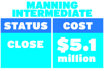
A graphic giving the status of Manning Intermediate School.

A graphic giving the status of Glenmoor Primary School.
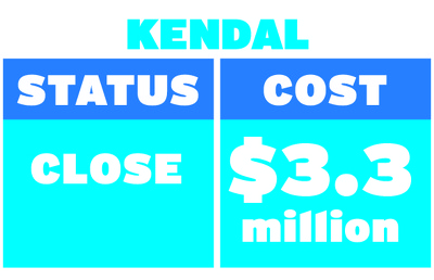
A graphic giving the status of Kendal Primary School.

A graphic giving the status of Branston Intermediate School.

A graphic giving the status of Burwood School.

A graphic giving the status of Discovery 1 School.

An illustration of a proposal for Christ Church Cathedral.

A page banner promoting an article titled, "Town Hall in balance".

A page banner promoting an article titled, "Parata rules out mergers".

A graphic giving the status of Aranui Primary School.
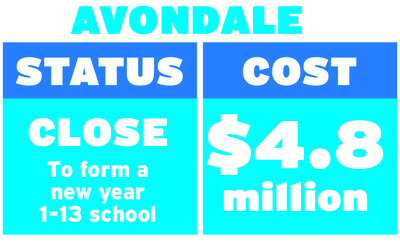
A graphic giving the status of Avondale Primary School.