
Christchurch Earthquake Aftermath
PWS-2010-09-12-DSC02233

20100905_3347_1D3-32 Bridge Street split depth - Christchurch earthquake
The city side of the South Brighton bridge. Approaches on both sides will need extensive work before this bridge can re-open.
Bridge opened for traffic less than a week later, but still (23/09) has 30kmh speed restriction.
#378

20100904_3327_1D3-65 Community Energy Action - Christchurch earthquake
Community Energy Action Trust on Moorhouse Ave.
#376

20100904_3315_1D3-24 Broken footpath - Christchurch earthquake
The footpath besides ANZAC Drive and the Bexley Wetlands. Liquefaction silt from well underground has flowed to the surface.
Photo taken less than three hours after the 4:35am earthquake.
#374

The September Canterbury earthquake. These pictures were taken of Colombo Street in Sydenham. A lot of masonry in this area has been damaged/fallen down.
Ascot TV. This has relocated further south on Colombo Street. Apparently their building on Cranford Street was also severely damaged.
Note: these photos were taken on a cellphone; mind the qu...

Slipping of the tectonic plates caused tension cracks on this previously unknown faultline that runs through this paddock; magnitude 7.1 earthquake in mid-Canterbury on Saturday 4 September 2010.

This originally straight farm fence has been laterally displaced at least 2 metres where it crosses the previously unknown faultline from which the Saturday 4 September 2010 earthquake originated.

This originally straight farm fence has been laterally displaced at least 2 metres where it crosses the previously unknown faultline from which the Saturday 4 September 2010 earthquake originated.

The faultline cuts across Telegraph Road, leaving a kink in its originally straight alignment; aftermath of the magnitude 7.1 earthquake in mid-Canterbury on Saturday 4 September 2010.

Column reinforcement exposed under spalled concrete after the magnitude 7.1 earthquake that struck Christchurch on Saturday 4 September 2010.

Column reinforcement exposed under spalled concrete after the magnitude 7.1 earthquake that struck Christchurch on Saturday 4 September 2010.

This 2 storey building has been condemned after its roof collapsed during the magnitude 7.1 earthquake in Christchurch on Saturday 4-9-2010.

Police road block on Colombo Street; aftermath of the magnitude 7.1 earthquake in Christchurch on Saturday 4-9-2010. Note the unusually deserted streets on a Tuesday afternoon.

Christchurch city experienced a magnitude 7.1 earthquake on September 4, at 4:35 am. The epicentre was 40 km west of the city. It is the most damaging earthquake in New Zealand since the Hawke's Bay earthquake in 1931, but there was no loss of life. It was fortunate the earthquake occurred when the central city streets were deserted, as there ...

Toppled grain silos on the outskirts of Darfield near the epicentre of the magnitude 7,1 earthquake that struck on Saturday 4 September 2010.

Toppled grain silos on the outskirts of Darfield near the epicentre of the magnitude 7,1 earthquake that struck on Saturday 4 September 2010.

Slipping of the tectonic plates caused tension cracks on this previously unknown faultline that runs through this paddock; magnitude 7.1 earthquake in mid-Canterbury on Saturday 4 September 2010.

Slipping of the tectonic plates caused tension cracks on this previously unknown faultline that runs through this paddock; magnitude 7.1 earthquake in mid-Canterbury on Saturday 4 September 2010.
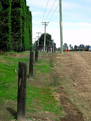
The farmer swore that his fence was erected in a straingt line, but mother nature had other ideas!
Aftermath of the Saturday 4 September 2010 magnitude 7.1 earthquake at the previously unknown faultline along which the quake originated.

Hehehe ..... did the surveyors get the road setout wrong?
This previously straight road is now kinked across this previously unknown faultline along which the Saturday 4 September 2010 magnitude 7.1 earthquake originated.

These diggers finished off what the quake failed to completely destroy; aftermath of the magnitude 7.1 earthquake that struck Christchurch on Saturday 4 September 2010.

This shop at the Colombo Street / Tuam Street corner lost its side wall in the magnitude 7.1 earthquake that struck Christchurch on Saturday 4 September 2010.

Nearing the end of demolition of the Westend Jewellers site on the corner of Worcester and Manchester Streets, Christchurch. Badly damaged in the September 4th earthquake.

Canterbury Earthquake 04/09/10
Christchurch
New Zealand

20100918_3497_1D3-24 Porritt Park - Christchurch earthquake
The Avon River loop around Porritt Park has risen with the quake. Huge cracks are all through Porritt Park (rowing, hockey and cricket venue). The main section of the river is in a man made cut behind the buildings in the background of this pic.
#401

20100905_3346_1D3-24 Bridge Street cracking - Christchurch earthquake
The city side of the South Brighton bridge. Approaches on both sides will need extensive work before this bridge can re-open.
#379

20100904_3310_1D3-24 Christchurch earthquake
Birch Street flooded from burst water main
#371

20100904_3309_1D3-24 Christchurch earthquake
Wairoa Street
Another web site used this image (with a link to this Flickr page), so the view count sky rocketed.
CERA (Canterbury Earthquake Recovery Authority)/Tonkin & Taylor also used this image on page 13 of a Land Damage presentation on 23/06/11. This was also released as a PDF. A few mo...

The September Canterbury earthquake. These pictures were taken of Colombo Street in Sydenham. A lot of masonry in this area has been damaged/fallen down.
Note: these photos were taken on a cellphone; mind the quality.

The September Canterbury earthquake. These pictures were taken of Colombo Street in Sydenham. A lot of masonry in this area has been damaged/fallen down.
Note: these photos were taken on a cellphone; mind the quality.