
Armagh Street, near the corner of Durham Street North, looking east-ish towards the Canterbury Provincial Council and Supreme Court Buildings.

A photograph of a veterinarian and animal attendant at SPCA Canterbury after the 22 February 2011 earthquake.
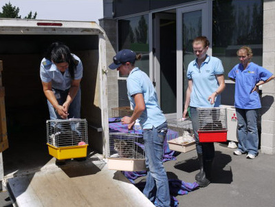
A photograph of members of the SPCA preparing cats for relocation after the 22 February 2011 earthquake.

One white over-painted hand-made electric guitar made primarily from ash and maple timbers, also incorporating wood from a variety of historic buildings in Canterbury damaged or destroyed in the 2010 - 2011 earthquakes including the Arts Centre, Kutwell’s Warehouse, Lyttleton main street pub, Timeball Station, Carlton Hotel, Merivale shops, bui...

One white cotton t-shirt with red printed guitar logo on front and ‘Band / Together / Concert / for / Canterbury // 23rd October / Hagley Park’ in black and red writing, guitar logo and names of performers on the reverse. This concert was a free morale booster following the 4 September 2010 earthquake. The 4 September 2010 earthquake unsettled ...

One landscape colour digital photograph taken on 25 February 2011 showing earthquake damage to the corner of Canterbury and London Streets. The photograph is taken from Canterbury Street looking down hill. The buildings visible are The Volcano Restaurant, the Lyttelton Library, the Lyttelton Working Mens' Club (The Loons), and the Royal Hotel (o...

Photo of earthquake damage on Double Days Road taken by Kate Roughan, 8 September 2010.

A photograph of University of Canterbury students carrying wheelbarrows, shovels and spades to help clean up liquefaction in earthquake-damaged areas after the September 2010 earthquake.

Colombo Street, looking north from Cathedral Square

Kilmore Street looking west from Manchester Street

Roy Stokes Hall New Brighton - Welfare Distribution Centre

Structural engineers inspecting the Warners Novotel, Cathedral Square.

One twisted rectangular metal sign engraved with the words 'Pyne Gould Corporation' in black. Recovered from the Pyne Gould Corporation Building following the 22 February earthquake. The Pyne Gould Corporation (PGC) building, which was located on Cambridge Terrace in central Christchurch, collapsed during the 22 February 2011 earthquake with 18...

One trophy made from a can attached to a wooden base issued to SCIRT as a thank you for participating in Canstruction Christchurch. Features a custom printed label which celebrates teamwork in place of the usual nutritional information.
One landscape colour digital photograph taken on 25 February 2011 showing earthquake damage to houses on the western side of Canterbury Street between London and Winchester Streets. The photograph shows large sections of a brick firewall which have fallen onto the roof of the neighbouring house. The close proximity of buildings in Lyttelton led...

One landscape colour digital photograph taken on 6 September 2010 showing water table alteration in Hagley Park from near the Armagh Street bridge. Localised flooding was an almost immediate after effect of the 2010-2011 Canterbury earthquakes. Some areas of Christchurch were submerged, sometimes for several days, following the earthquake espec...

One landscape colour digital photograph taken on 6 September 2010 showing earthquake damage to a red brick fence on Bealey Avenue. Unreinforced brick masonry was particularly susceptible to damage during the 2010-2011 Canterbury earthquakes. Walls and fences constructed from on many properties were shaken loose causing piles of rubble to litter...

One cast iron and perspex turret clock dial with two hands. Originally from the tower of the Christchurch railway station building on Moorehouse Avenue, which later became the science education centre Science Alive!

One cast iron and perspex turret clock dial with two hands. Originally from the tower of the Christchurch railway station building on Moorehouse Avenue, which later became the science education centre Science Alive!

Liquefaction on the side of a road in Avonside after the September 4th earthquake.

Cracks on the side of the road in Avonside after the September 4th earthquake.
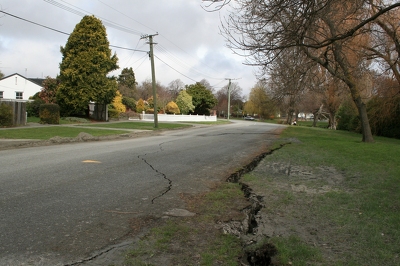
Cracks along the road and river bank in Avonside after the September 4th earthquake.

A crack in the Avon river bank in Avonside after the September 4th earthquake.
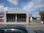
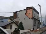
One landscape colour digital photograph taken on 19 November 2011 showing the Lyttelton Fire Station. The building is fenced off and unused due to earthquake damage. To the right of the photograph the front of one of the Fire Appliances and the shipping containers set up in the rear car park to provide temporary facilities can be seen. Followin...

One landscape colour digital photograph taken on 19 November 2011 showing the temporary premises of the Bank of New Zealand in a relocatable building on the footpath. The sign above the tellers window read "Lyttel Bank" The Lyttelton streetscape has changed dramatically from its pre-earthquake appearance and will continue to change as new build...

One landscape colour digital photograph taken on 19 November 2011 showing the site of the old Lyttelton Library, Council Chambers and Magistrates' Court on the corner of Oxford Street and Sumner Road. At the time of the 22 February 2011 Earthquake the building was in private ownership and was the premises of Moda Fotografica and a private resid...

One landscape colour digital photograph taken on 27 May 2013 of a retaining wall in Sumner Road which was replaced due to earthquake damage. The original wall was created using red volcanic rock. Many walls like this were built using the Hard Labour Gang from the Lyttelton Gaol. The replacement wall has a small section of stone installed to sho...

One landscape colour digital photograph taken on 27 May 2013 of a retaining wall in Sumner Road which was replaced due to earthquake damage. The original wall was created using red volcanic rock. Many walls like this were built using the Hard Labour Gang from the Lyttelton Gaol. The replacement wall has a small section of stone installed to sho...

One landscape colour digital photograph taken on 25 September 2011 showing the site of the Lyttelton Historical Museum on the corner of Gladstone Quay and Donald Street. The photograph shows the temporary fencing around the levelled site. The building visible at the rear is the former Municipal Stables on Donald Street. To the right of the phot...

One landscape colour digital photograph taken on 30 June 2011 showing signs warning of the danger posed by unstable headstones in Lyttelton Roman Catholic and Dissenters (Public) Cemeteries in Reserve Terrace. Several toppled headstones and collapsed grave surrounds are visible in the photograph. Looking east from the main gate. The Lyttelton c...