
None

This is the Summit Road below Mt Cavendish and shows a few remaining high buildings in the central city beyond (in setting sun). Just above centre is the doomed AMI Stadium (1) aka Lancaster Park, home to Canterbury cricket and rugby till the erathquakes.

35 Hargood Street, Woolston - earthquake land damage. Second house away from the Woolston Club.
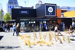
Christchurch - Earthquake Rebuild - Temporary CBD
Christchurch City CBD
Cashel Street
Christchurch
Canterbury
New Zealand
© 2011 Phil Le Cren
Photo Taken With:
Canon EOS 1000D
+ Canon EF/EF-S lenses
+ 10.1 effective megapixels
+ 2.5-inch TFT color LCD monitor
+ Eye-level pentamirror SLR
+ Live View shooting.
+ EOS Built-in Sensor...

Hargood Street (23.02.2011)
Woolston
Christchurch
Canterbury
New Zealand
© 2011 Phil Le Cren
Photo Taken With:
Canon EOS 1000D
+ Canon EF/EF-S lenses
+ 10.1 effective megapixels
+ 2.5-inch TFT color LCD monitor
+ Eye-level pentamirror SLR
+ Live View shooting.
+ EOS Built-in Sensor cleaning system
+ Wide-area 7 poin...

Shops (23.02.2011)
Woolston
Christchurch
Canterbury
New Zealand
© 2011 Phil Le Cren
Photo Taken With:
Canon EOS 1000D
+ Canon EF/EF-S lenses
+ 10.1 effective megapixels
+ 2.5-inch TFT color LCD monitor
+ Eye-level pentamirror SLR
+ Live View shooting.
+ EOS Built-in Sensor cleaning system
+ Wide-area 7 point AF with...

813 Colombo Street looking south-ish, near the corner of Peterborough Street.

Kilmore St and Barbadoes St Intersection

Suburbs

Suburbs

St Marys Church

Our Garage

Edgeware Supervalue Supermarket being demolished after the 6.3 magnitude quake hit Christchurch 22 February 2011.

Sadly the Chapel has been badly damaged in the magnitude 6.3 earthquake that hit Christchurch 22 February 2011. See below.
The Rose Historic Chapel formerly St Mary’s Convent Chapel is the sole survivor of a group of heritage buildings in Christchurch that once comprised the St Mary’s Convent complex for the Sisters of Mercy in North Colombo St...

Post the earthquakes land has sunk and in this case the track is below high tide level. It would have been at least 500mm above the highest tide level prior to the recent earthquakes that started on 04/09/10.

None

Here's Prarie, outside our flat, the day after the 7.1 earthquake hit Christchurch. You see the damage to the street, which continued through our flat. We were forced to move out once an engineer examined the cracks in our balcony, walls, floors, and ceilings, and told us the building was unsafe for living. One crack ran from the street, pres...

The center of the river has slumped and the two banks have moved about a meter closer together which caused this footbridge to be so twisted. There is a suggestion that this be left as a memorial to the earthquake.

Oxford Terrace Baptist Church on the corner of Madras St and Oxford Terrace, and alongside the Central City Fire Station on Kilmore St.

Oxford Terrace Baptist Church on the corner of Madras St and Oxford Terrace, and alongside the Central City Fire Station on Kilmore St.

Manchester and Gloucester Street corner

Christchurch Cathedral, Cathedral Square.

Aftermath of September 4th Earthquake in Canterbury (area covers Christchurch City) NZ. Storm drains - Anfield Street, Brooklands.

St Martins Library Taken several days after the 6.3 magnatude quake hit Christchurch 22 February 2011. Processed in HDR to capture some of the "feeling" when thinking about the loss of lives when the quake hit.

None

None

Looking across to the Town Hall. Will it stay or will it go?

None

None